Property Record
3121 Bankhead Dr, Little Rock, AR 72206


NEARBY LISTINGS FOR SALE OR LEASE
-
-
View all Little Rock listings for sale on LoopNet.com
Property Detail
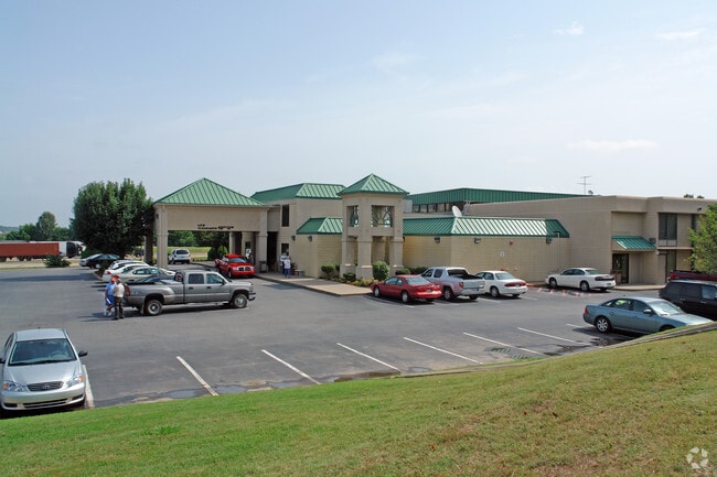
3121 Bankhead Dr
24L-018-00-006-00
PART SE NE SECTION 18-1N-11 MPDA COM SE COR NE TH N87*952W AL SLN NE 300.08 TO POB TH CONTINUING N87*952W794.27 N39*2851W55.39 AL ACCESS EASEMENT N03*2510E32.30 N86*3450W20 TO EAST R/W BANKHEAD DRIVE
Hotel
Pulaski
X
Arkansas
05119C0478G
5.44 AC
2025
Little Rock
2025
Little Rock/N Little Rock
004001
Little Rock-North Little Rock-Conway, AR
78,396 SF
DEMOGRAPHICS near 3121 Bankhead Dr
1 Mile
3 Mile
5 Mile
2024 Total Population
625
9,147
41,610
2029 Population
580
9,369
42,792
Pop Growth 2024-2029
(7.20%)
+ 2.43%
+ 2.84%
Average Age
41
40
40
2024 Total Households
276
4,059
19,531
HH Growth 2024-2029
(6.88%)
+ 2.44%
+ 2.87%
Median Household Inc
$64,000
$27,387
$35,510
Avg Household Size
2.30
2.20
2.00
2024 Avg HH Vehicles
2.00
1.00
1.00
Median Home Value
$140,551
$89,553
$102,844
Median Year Built
1992
1968
1967
Nearby Places
Map Layers
Map Styles
 Street
 Aerial
- Restaurants
- Banks
- Shops
- Fitness
- Groceries
PUBLIC TRANSPORTATION
COMMUTER RAIL
DRIVE
WALK
Distance
11 min
6.5 mi
AIRPORT
Bill and Hillary Clinton Ntl/Adams Field
DRIVE
WALK
Distance
Bill and Hillary Clinton Ntl/Adams Field
3 min
1.2 mi
Nearby Properties
Address
Land Use
TOTAL SIZE
Lot Size
Zoning
Address
Land Use
TOTAL SIZE
Lot Size
Zoning
855,268 SF
82.05 AC
Address
Land Use
TOTAL SIZE
Lot Size
Zoning
412,597 SF
Address
Land Use
TOTAL SIZE
Lot Size
Zoning
267,152 SF
Address
Land Use
TOTAL SIZE
Lot Size
Zoning
143,553 SF
12.76 AC
Address
Land Use
TOTAL SIZE
Lot Size
Zoning
130,742 SF
15.71 AC
Address
Land Use
TOTAL SIZE
Lot Size
Zoning
95,719 SF
32.76 AC
Address
Land Use
TOTAL SIZE
Lot Size
Zoning
550,000 SF
39.66 AC
Address
Land Use
TOTAL SIZE
Lot Size
Zoning
138,352 SF
2.95 AC
Address
Land Use
TOTAL SIZE
Lot Size
Zoning
61,225 SF
5.66 AC
Address
Land Use
TOTAL SIZE
Lot Size
Zoning
142,944 SF
Address
Land Use
TOTAL SIZE
Lot Size
Zoning
5,949 SF
25.53 AC
Address
Land Use
TOTAL SIZE
Lot Size
Zoning
153,264 SF
2.45 AC
Address
Land Use
TOTAL SIZE
Lot Size
Zoning
345,807 SF
69.54 AC
Address
Land Use
TOTAL SIZE
Lot Size
Zoning
112,500 SF
72.59 AC
Address
Land Use
TOTAL SIZE
Lot Size
Zoning
52,026 SF
23.02 AC
Address
Land Use
TOTAL SIZE
Lot Size
Zoning
124,800 SF
23.82 AC
Address
Land Use
TOTAL SIZE
Lot Size
Zoning
31,810 SF
39.99 AC
Address
Land Use
TOTAL SIZE
Lot Size
Zoning
95,472 SF
44.21 AC
Address
Land Use
TOTAL SIZE
Lot Size
Zoning
76,733 SF
Address
Land Use
TOTAL SIZE
Lot Size
Zoning
27,000 SF
9.99 AC
Address
Land Use
TOTAL SIZE
Lot Size
Zoning
272,446 SF
21.74 AC
Address
Land Use
TOTAL SIZE
Lot Size
Zoning
57,648 SF
389.29 AC
Address
Land Use
TOTAL SIZE
Lot Size
Zoning
131,025 SF
176.44 AC
Address
Land Use
TOTAL SIZE
Lot Size
Zoning
1,380 SF
514.53 AC
Address
Land Use
TOTAL SIZE
Lot Size
Zoning
29,792 SF
26.14 AC
Address
Land Use
TOTAL SIZE
Lot Size
Zoning
7,393 SF
38.01 AC
Address
Land Use
TOTAL SIZE
Lot Size
Zoning
18,444 SF
1.23 AC
Address
Land Use
TOTAL SIZE
Lot Size
Zoning
8,972 SF
15.89 AC
Address
Land Use
TOTAL SIZE
Lot Size
Zoning
30,400 SF
Address
Land Use
TOTAL SIZE
Lot Size
Zoning
7,216 SF
16.01 AC
The World's #1 Commercial Real Estate Marketplace
Connect with us
© 2026 CoStar Group
The information above has been obtained from sources believed reliable. While we do not doubt its accuracy we have not verified it and make no guarantee, warranty or representation about it. It is your responsibility to independently confirm its accuracy and completeness. Any projections, opinions, assumptions, or estimates used are for example only and do not represent the current or future performance of the property. The value of this transaction to you depends on tax and other factors which should be evaluated by your tax, financial, and legal advisors. You and your advisors should conduct a careful, independent investigation of the property to determine to your satisfaction the suitability of the property for your needs.