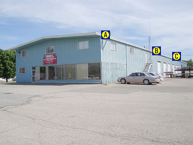
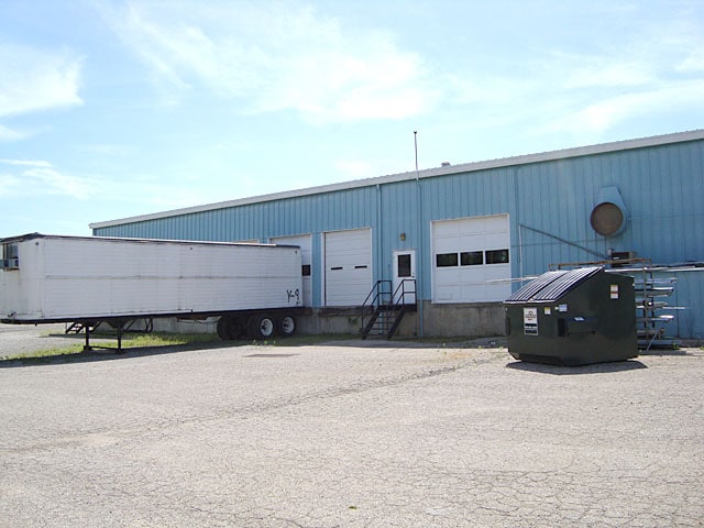
Property Record
3121 Se 6Th Ave, Topeka, KS 66607

Property Detail
3121 Se 6Th Ave
132-04-0-10-02-001-000
RESERS SUB NO 2, S04, T12, R16, BLOCK A, LOT 1, ACRES 7.4
Shipyard
SHAWNEE
I1
Kansas
B and X Area of moderate flood hazard, usually the area between the limits of the 100-year and 500-year floods.
1
2024
7.40 AC
2025
Topeka
003100
Kansas City
152,960 SF
Topeka, KS
NEARBY LISTINGS FOR SALE OR LEASE
DEMOGRAPHICS near 3121 Se 6Th Ave
1 mile
3 mile
5 mile
2025 Total Population
5,493
44,090
95,712
2030 Population
5,588
44,575
96,366
Pop Growth 2025-2030
+ 1.73%
+ 1.10%
+ 0.68%
Average Age
37
39
40
2025 Total Households
1,729
17,221
39,039
HH Growth 2025-2030
+ 1.97%
+ 1.29%
+ 0.76%
Median Household Inc
$26,946
$45,306
$52,856
Avg Household Size
2.50
2.40
2.30
2025 Avg HH Vehicles
1.00
2.00
2.00
Median Home Value
$71,856
$95,759
$129,660
Median Year Built
1966
1959
1961
Nearby Places
Map Layers
Map Styles
 Street
 Aerial
Transit
 Traffic
 Biking
Places
Listings with unknown addresses are not visible on the map
- Restaurants
- Banks
- Shops
- Fitness
- Groceries
PUBLIC TRANSPORTATION
COMMUTER RAIL
Drive
Walk
Distance
5 min
2.3 mi
Nearby Properties
Address
Land Use
TOTAL SIZE
Lot Size
Zoning
Address
Land Use
TOTAL SIZE
Lot Size
Zoning
52,453 SF
17.12 AC
C5,OI2
Address
Land Use
TOTAL SIZE
Lot Size
Zoning
64,058 SF
3.31 AC
C4,OI2
Address
Land Use
TOTAL SIZE
Lot Size
Zoning
336,669 SF
58.82 AC
PUD,C4
Address
Land Use
TOTAL SIZE
Lot Size
Zoning
3.31 AC
OI2
Address
Land Use
TOTAL SIZE
Lot Size
Zoning
285,005 SF
3.10 AC
C4,C5,I1
Address
Land Use
TOTAL SIZE
Lot Size
Zoning
65,687 SF
7.47 AC
C2,I1,M2
Address
Land Use
TOTAL SIZE
Lot Size
Zoning
137,637 SF
10.43 AC
M2
Address
Land Use
TOTAL SIZE
Lot Size
Zoning
98,898 SF
1.91 AC
C5
Address
Land Use
TOTAL SIZE
Lot Size
Zoning
107,592 SF
14.98 AC
C4,I1,OI2
Address
Land Use
TOTAL SIZE
Lot Size
Zoning
181,781 SF
569.17 AC
R1
Address
Land Use
TOTAL SIZE
Lot Size
Zoning
127,947 SF
7.12 AC
C5
Address
Land Use
TOTAL SIZE
Lot Size
Zoning
54,654 SF
0.56 AC
C5
Address
Land Use
TOTAL SIZE
Lot Size
Zoning
112,413 SF
0.73 AC
C5
Address
Land Use
TOTAL SIZE
Lot Size
Zoning
101,766 SF
2.39 AC
C5,I1
Address
Land Use
TOTAL SIZE
Lot Size
Zoning
101,166 SF
3.31 AC
C5
Address
Land Use
TOTAL SIZE
Lot Size
Zoning
165,001 SF
24.83 AC
R1
Address
Land Use
TOTAL SIZE
Lot Size
Zoning
161,335 SF
37.32 AC
R1
Address
Land Use
TOTAL SIZE
Lot Size
Zoning
92,118 SF
10.87 AC
R2
Address
Land Use
TOTAL SIZE
Lot Size
Zoning
61,680 SF
2.20 AC
C5
Address
Land Use
TOTAL SIZE
Lot Size
Zoning
188,606 SF
8.42 AC
I1
Address
Land Use
TOTAL SIZE
Lot Size
Zoning
51,514 SF
1.87 AC
I2
Address
Land Use
TOTAL SIZE
Lot Size
Zoning
50,453 SF
14.29 AC
PUD,M2
Address
Land Use
TOTAL SIZE
Lot Size
Zoning
15,927 SF
1.44 AC
C4
Address
Land Use
TOTAL SIZE
Lot Size
Zoning
70,058 SF
1.03 AC
C5
Address
Land Use
TOTAL SIZE
Lot Size
Zoning
75,691 SF
5.91 AC
M1,M2
Address
Land Use
TOTAL SIZE
Lot Size
Zoning
25,758 SF
1.64 AC
M2
Address
Land Use
TOTAL SIZE
Lot Size
Zoning
69,020 SF
26.47 AC
RR1
Address
Land Use
TOTAL SIZE
Lot Size
Zoning
21,978 SF
2.79 AC
C2,M4
Address
Land Use
TOTAL SIZE
Lot Size
Zoning
77,793 SF
10.87 AC
C2,M1
Address
Land Use
TOTAL SIZE
Lot Size
Zoning
14,216 SF
0.78 AC
The World's #1 Commercial Real Estate Marketplace
Connect with us
© 2026 CoStar Group
The information above has been obtained from sources believed reliable. While we do not doubt its accuracy we have not verified it and make no guarantee, warranty or representation about it. It is your responsibility to independently confirm its accuracy and completeness. Any projections, opinions, assumptions, or estimates used are for example only and do not represent the current or future performance of the property. The value of this transaction to you depends on tax and other factors which should be evaluated by your tax, financial, and legal advisors. You and your advisors should conduct a careful, independent investigation of the property to determine to your satisfaction the suitability of the property for your needs.