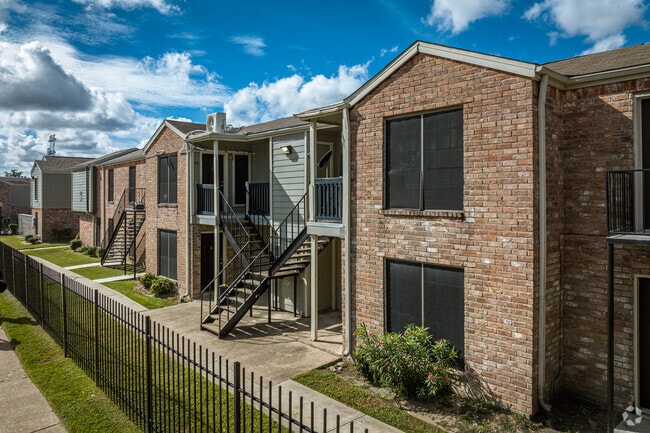
Property Record
3125 Crestdale Dr, Houston, TX 77080
NEARBY LISTINGS FOR SALE OR LEASE
Property Detail
3125 Crestdale Dr
0432220000100
Abst 556 A T Miles
Apartment
TRS 13E 13H 13K 13L & 26 ABST 556 A T MILES
X
Harris
48201C0635M
Texas
2024
27.11 AC
2025
Spring Shadows
522102
Houston
802,913 SF
Houston-The Woodlands-Sugar Land, TX
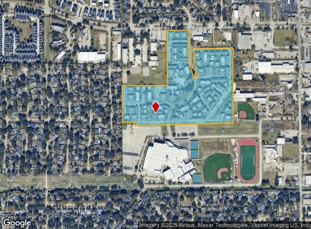
DEMOGRAPHICS near 3125 Crestdale Dr
1 Mile
3 Mile
5 Mile
2024 Total Population
21,065
125,502
293,868
2029 Population
21,771
129,129
301,534
Pop Growth 2024-2029
+ 3.35%
+ 2.89%
+ 2.61%
Average Age
37
36
37
2024 Total Households
7,681
45,488
110,070
HH Growth 2024-2029
+ 3.55%
+ 3.01%
+ 2.68%
Median Household Inc
$66,198
$55,191
$65,899
Avg Household Size
2.60
2.70
2.60
2024 Avg HH Vehicles
2.00
2.00
2.00
Median Home Value
$285,884
$306,675
$359,324
Median Year Built
1972
1976
1978
Nearby Places
Map Layers
Map Styles
 Street
 Aerial
- Restaurants
- Banks
- Shops
- Fitness
- Groceries
PUBLIC TRANSPORTATION
AIRPORT
William P Hobby
DRIVE
WALK
Distance
William P Hobby
42 min
26.0 mi
George Bush Intcntl/Houston
DRIVE
WALK
Distance
George Bush Intcntl/Houston
34 min
26.5 mi
Freight Ports
Port of Houston
DRIVE
WALK
Distance
Port of Houston
35 min
22.8 mi
SALE & LEASE HISTORY
LISTING DATE
SALE/LEASE

Jun 24, 2020
For Sale
Jul 15, 2020
For Sale
Jan 12, 2023
For Sale
Aug 12, 2020
For Sale
Nearby Properties
Address
Land Use
TOTAL SIZE
Lot Size
Zoning
Address
Land Use
TOTAL SIZE
Lot Size
Zoning
578,530 SF
32.81 AC
Address
Land Use
TOTAL SIZE
Lot Size
Zoning
935,613 SF
27.93 AC
Address
Land Use
TOTAL SIZE
Lot Size
Zoning
797,516 SF
2.91 AC
Address
Land Use
TOTAL SIZE
Lot Size
Zoning
797,509 SF
3.11 AC
Address
Land Use
TOTAL SIZE
Lot Size
Zoning
730,107 SF
2.92 AC
Address
Land Use
TOTAL SIZE
Lot Size
Zoning
730,107 SF
2.57 AC
Address
Land Use
TOTAL SIZE
Lot Size
Zoning
955,731 SF
3.40 AC
Address
Land Use
TOTAL SIZE
Lot Size
Zoning
542,880 SF
1.22 AC
Address
Land Use
TOTAL SIZE
Lot Size
Zoning
743,954 SF
2.97 AC
Address
Land Use
TOTAL SIZE
Lot Size
Zoning
487,073 SF
44.12 AC
Address
Land Use
TOTAL SIZE
Lot Size
Zoning
507,014 SF
2.93 AC
Address
Land Use
TOTAL SIZE
Lot Size
Zoning
357,280 SF
1.72 AC
Address
Land Use
TOTAL SIZE
Lot Size
Zoning
497,932 SF
3.97 AC
Address
Land Use
TOTAL SIZE
Lot Size
Zoning
656,741 SF
1.88 AC
Address
Land Use
TOTAL SIZE
Lot Size
Zoning
793,669 SF
121.83 AC
Address
Land Use
TOTAL SIZE
Lot Size
Zoning
504,256 SF
6.09 AC
Address
Land Use
TOTAL SIZE
Lot Size
Zoning
544,102 SF
2.99 AC
Address
Land Use
TOTAL SIZE
Lot Size
Zoning
199,423 SF
Address
Land Use
TOTAL SIZE
Lot Size
Zoning
519,220 SF
6.23 AC
Address
Land Use
TOTAL SIZE
Lot Size
Zoning
726,444 SF
7.29 AC
Address
Land Use
TOTAL SIZE
Lot Size
Zoning
324,600 SF
2.06 AC
Address
Land Use
TOTAL SIZE
Lot Size
Zoning
729,149 SF
2.32 AC
Address
Land Use
TOTAL SIZE
Lot Size
Zoning
475,272 SF
4.73 AC
Address
Land Use
TOTAL SIZE
Lot Size
Zoning
475,976 SF
2.83 AC
Address
Land Use
TOTAL SIZE
Lot Size
Zoning
342,163 SF
8.50 AC
Address
Land Use
TOTAL SIZE
Lot Size
Zoning
596,920 SF
2.38 AC
Address
Land Use
TOTAL SIZE
Lot Size
Zoning
427,921 SF
18.14 AC
Address
Land Use
TOTAL SIZE
Lot Size
Zoning
251,980 SF
2.55 AC
Address
Land Use
TOTAL SIZE
Lot Size
Zoning
336,681 SF
16.10 AC
Address
Land Use
TOTAL SIZE
Lot Size
Zoning
151,313 SF
1.21 AC
The World's #1 Commercial Real Estate Marketplace
Connect with us
© 2026 CoStar Group
The information above has been obtained from sources believed reliable. While we do not doubt its accuracy we have not verified it and make no guarantee, warranty or representation about it. It is your responsibility to independently confirm its accuracy and completeness. Any projections, opinions, assumptions, or estimates used are for example only and do not represent the current or future performance of the property. The value of this transaction to you depends on tax and other factors which should be evaluated by your tax, financial, and legal advisors. You and your advisors should conduct a careful, independent investigation of the property to determine to your satisfaction the suitability of the property for your needs.