Property Record
3125 Penryn Rd, Penryn, CA 95663
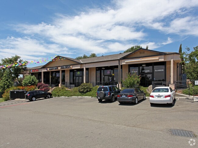

Property Detail
3125 Penryn Rd
043-060-062
5.3 AC SEC 2 11 7
Regionalshoppingcenterormallwithanchorstore
Placer
C1UPDC
California
B and X Area of moderate flood hazard, usually the area between the limits of the 100-year and 500-year floods.
5.30 AC
2024
Auburn/Loomis
2025
Sacramento
021204
Sacramento-Roseville-Folsom, CA
30,209 SF
NEARBY LISTINGS FOR SALE OR LEASE
DEMOGRAPHICS near 3125 Penryn Rd
1 mile
3 mile
5 mile
2025 Total Population
1,499
16,117
55,593
2030 Population
1,553
16,823
58,503
Pop Growth 2025-2030
+ 3.60%
+ 4.38%
+ 5.23%
Average Age
42
43
44
2025 Total Households
531
5,751
20,536
HH Growth 2025-2030
+ 3.77%
+ 4.38%
+ 5.22%
Median Household Inc
$120,771
$138,671
$134,006
Avg Household Size
2.70
2.80
2.70
2025 Avg HH Vehicles
3.00
2.00
2.00
Median Home Value
$848,085
$792,680
$792,182
Median Year Built
1979
1981
1993
Nearby Places
Map Layers
Map Styles
 Street
 Aerial
Layers
 Traffic
 Biking
Places
Listings with unknown addresses are not visible on the map
- Restaurants
- Banks
- Shops
- Fitness
- Groceries
PUBLIC TRANSPORTATION
COMMUTER RAIL
Drive
Walk
Distance
8 min
5.4 mi
Drive
Walk
Distance
12 min
8.4 mi
AIRPORT
Sacramento International
Drive
Walk
Distance
Sacramento International
43 min
33.1 mi
Nearby Properties
Address
Land Use
TOTAL SIZE
Lot Size
Zoning
Address
Land Use
TOTAL SIZE
Lot Size
Zoning
159,029 SF
17.62 AC
Address
Land Use
TOTAL SIZE
Lot Size
Zoning
1,992 SF
44.99 AC
RAB100
Address
Land Use
TOTAL SIZE
Lot Size
Zoning
100,348 SF
12.50 AC
Address
Land Use
TOTAL SIZE
Lot Size
Zoning
89,928 SF
6 AC
CG
Address
Land Use
TOTAL SIZE
Lot Size
Zoning
63,608 SF
5.20 AC
CG
Address
Land Use
TOTAL SIZE
Lot Size
Zoning
25,368 SF
1.08 AC
RH
Address
Land Use
TOTAL SIZE
Lot Size
Zoning
17,733 SF
1.40 AC
C1UPDC
Address
Land Use
TOTAL SIZE
Lot Size
Zoning
26,750 SF
5.20 AC
CG
Address
Land Use
TOTAL SIZE
Lot Size
Zoning
12,259 SF
2.60 AC
RE
Address
Land Use
TOTAL SIZE
Lot Size
Zoning
4,177 SF
1.30 AC
Address
Land Use
TOTAL SIZE
Lot Size
Zoning
61,024 SF
3 AC
IL
Address
Land Use
TOTAL SIZE
Lot Size
Zoning
22,204 SF
1.46 AC
Address
Land Use
TOTAL SIZE
Lot Size
Zoning
46,310 SF
3.16 AC
Address
Land Use
TOTAL SIZE
Lot Size
Zoning
126,472 SF
11.40 AC
IL
Address
Land Use
TOTAL SIZE
Lot Size
Zoning
5,653 SF
1.60 AC
Address
Land Use
TOTAL SIZE
Lot Size
Zoning
8,036 SF
0.85 AC
CG
Address
Land Use
TOTAL SIZE
Lot Size
Zoning
5,126 SF
1.40 AC
C1UPDC
Address
Land Use
TOTAL SIZE
Lot Size
Zoning
26,352 SF
1.70 AC
ILT
Address
Land Use
TOTAL SIZE
Lot Size
Zoning
6,932 SF
11.80 AC
RAB100
Address
Land Use
TOTAL SIZE
Lot Size
Zoning
11,084 SF
10 AC
Address
Land Use
TOTAL SIZE
Lot Size
Zoning
26,072 SF
2.10 AC
Address
Land Use
TOTAL SIZE
Lot Size
Zoning
2,945 SF
1 AC
Address
Land Use
TOTAL SIZE
Lot Size
Zoning
11,000 SF
0.56 AC
IL
Address
Land Use
TOTAL SIZE
Lot Size
Zoning
12,542 SF
3.60 AC
CG
Address
Land Use
TOTAL SIZE
Lot Size
Zoning
7,047 SF
7.20 AC
Address
Land Use
TOTAL SIZE
Lot Size
Zoning
10,000 SF
0.64 AC
IL
Address
Land Use
TOTAL SIZE
Lot Size
Zoning
4.02 AC
IL
Address
Land Use
TOTAL SIZE
Lot Size
Zoning
13,031 SF
0.89 AC
CG
The World's #1 Commercial Real Estate Marketplace
Connect with us
© 2026 CoStar Group
The information above has been obtained from sources believed reliable. While we do not doubt its accuracy we have not verified it and make no guarantee, warranty or representation about it. It is your responsibility to independently confirm its accuracy and completeness. Any projections, opinions, assumptions, or estimates used are for example only and do not represent the current or future performance of the property. The value of this transaction to you depends on tax and other factors which should be evaluated by your tax, financial, and legal advisors. You and your advisors should conduct a careful, independent investigation of the property to determine to your satisfaction the suitability of the property for your needs.