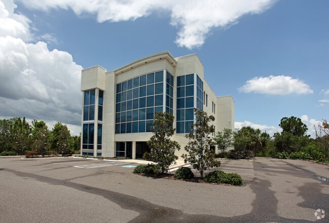
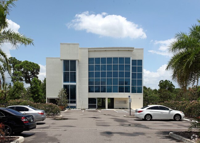
Property Record
3129 Alt 19, Palm Harbor, FL 34683


NEARBY LISTINGS FOR SALE OR LEASE
Property Detail
3129 Alt 19
11-28-15-32652-000-0120
Grand Bay Sub
Officebuilding
GRAND BAY SUB BLK KNOWN AS PARK BET BLKS P,X, & W
AE
Pinellas
12103C0067H
Florida
2024
1.99 AC
2025
North Pinellas
027206
Tampa/St Petersburg
14,770 SF
Tampa-St. Petersburg-Clearwater, FL
DEMOGRAPHICS near 3129 Alt 19
1 Mile
3 Mile
5 Mile
2024 Total Population
9,741
61,828
158,352
2029 Population
9,735
61,596
158,087
Pop Growth 2024-2029
(0.06%)
(0.38%)
(0.17%)
Average Age
52
49
49
2024 Total Households
4,676
28,322
74,819
HH Growth 2024-2029
0.00%
(0.39%)
(0.26%)
Median Household Inc
$58,485
$64,897
$61,082
Avg Household Size
2.00
2.10
2.00
2024 Avg HH Vehicles
1.00
2.00
2.00
Median Home Value
$339,682
$323,592
$291,893
Median Year Built
1983
1980
1981
Nearby Places
Map Layers
Map Styles
 Street
 Aerial
- Restaurants
- Banks
- Shops
- Fitness
- Groceries
PUBLIC TRANSPORTATION
AIRPORT
St Pete-Clearwater International
DRIVE
WALK
Distance
St Pete-Clearwater International
34 min
19.2 mi
Tampa International
DRIVE
WALK
Distance
Tampa International
35 min
19.6 mi
Freight Ports
Port of Tampa Bay
DRIVE
WALK
Distance
Port of Tampa Bay
48 min
28.0 mi
Nearby Properties
Address
Land Use
TOTAL SIZE
Lot Size
Zoning
Address
Land Use
TOTAL SIZE
Lot Size
Zoning
167,201 SF
63.11 AC
AE
Address
Land Use
TOTAL SIZE
Lot Size
Zoning
412,099 SF
49.21 AC
Address
Land Use
TOTAL SIZE
Lot Size
Zoning
270,606 SF
53.27 AC
AE
Address
Land Use
TOTAL SIZE
Lot Size
Zoning
242,708 SF
26.17 AC
RPD10
Address
Land Use
TOTAL SIZE
Lot Size
Zoning
239,480 SF
18.89 AC
RPD5
Address
Land Use
TOTAL SIZE
Lot Size
Zoning
117,024 SF
56.52 AC
Address
Land Use
TOTAL SIZE
Lot Size
Zoning
161,404 SF
18.48 AC
CP2
Address
Land Use
TOTAL SIZE
Lot Size
Zoning
199,825 SF
22.75 AC
R2
Address
Land Use
TOTAL SIZE
Lot Size
Zoning
151,398 SF
15.55 AC
CP1
Address
Land Use
TOTAL SIZE
Lot Size
Zoning
311,414 SF
15.59 AC
RPD75
Address
Land Use
TOTAL SIZE
Lot Size
Zoning
250,113 SF
39.50 AC
Address
Land Use
TOTAL SIZE
Lot Size
Zoning
116,975 SF
9 AC
AE
Address
Land Use
TOTAL SIZE
Lot Size
Zoning
173,160 SF
5.39 AC
Address
Land Use
TOTAL SIZE
Lot Size
Zoning
107,766 SF
25.15 AC
Address
Land Use
TOTAL SIZE
Lot Size
Zoning
158,400 SF
9.80 AC
Address
Land Use
TOTAL SIZE
Lot Size
Zoning
446,974 SF
11.32 AC
AE
Address
Land Use
TOTAL SIZE
Lot Size
Zoning
396,841 SF
9.73 AC
Address
Land Use
TOTAL SIZE
Lot Size
Zoning
94,029 SF
19.67 AC
RPD75
Address
Land Use
TOTAL SIZE
Lot Size
Zoning
415,593 SF
29.66 AC
Address
Land Use
TOTAL SIZE
Lot Size
Zoning
99,361 SF
12.64 AC
CP1
Address
Land Use
TOTAL SIZE
Lot Size
Zoning
92,817 SF
6.42 AC
PC
Address
Land Use
TOTAL SIZE
Lot Size
Zoning
76,848 SF
12.60 AC
AE
Address
Land Use
TOTAL SIZE
Lot Size
Zoning
93,840 SF
8.66 AC
CP1
Address
Land Use
TOTAL SIZE
Lot Size
Zoning
105,830 SF
10.84 AC
CP2
Address
Land Use
TOTAL SIZE
Lot Size
Zoning
85,666 SF
4.50 AC
R2
Address
Land Use
TOTAL SIZE
Lot Size
Zoning
90,791 SF
6.92 AC
Address
Land Use
TOTAL SIZE
Lot Size
Zoning
65,929 SF
5.96 AC
C2
Address
Land Use
TOTAL SIZE
Lot Size
Zoning
97,776 SF
9.63 AC
Address
Land Use
TOTAL SIZE
Lot Size
Zoning
103,393 SF
17.68 AC
R4
Address
Land Use
TOTAL SIZE
Lot Size
Zoning
101,243 SF
5.36 AC
M1
The World's #1 Commercial Real Estate Marketplace
Connect with us
© 2025 CoStar Group
The information above has been obtained from sources believed reliable. While we do not doubt its accuracy we have not verified it and make no guarantee, warranty or representation about it. It is your responsibility to independently confirm its accuracy and completeness. Any projections, opinions, assumptions, or estimates used are for example only and do not represent the current or future performance of the property. The value of this transaction to you depends on tax and other factors which should be evaluated by your tax, financial, and legal advisors. You and your advisors should conduct a careful, independent investigation of the property to determine to your satisfaction the suitability of the property for your needs.