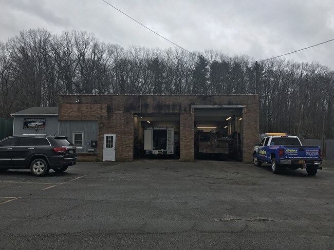
Property Record
3129 State Route 52, Pine Bush, NY 12566
NEARBY LISTINGS FOR SALE OR LEASE
Property Detail
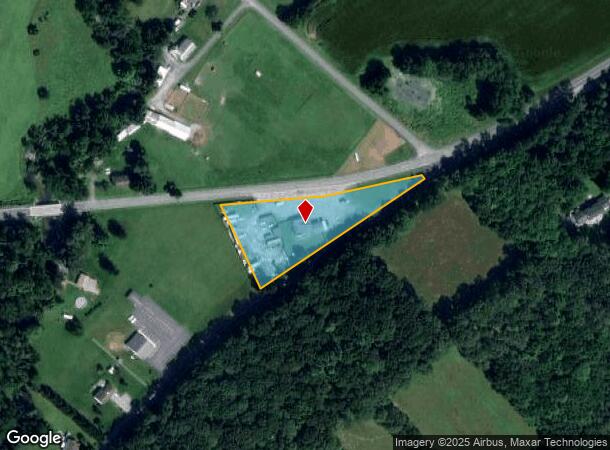
3129 State Route 52
5200-104.002-0003-026.000-0000
Ulster
Commercialnec
New York
X
26.000
36111C0830E
1.70 AC
2025
Hudson Valley Area
2024
Other Market Areas
954402
Kingston, NY
2,250 SF
DEMOGRAPHICS near 3129 State Route 52
1 Mile
3 Mile
5 Mile
2024 Total Population
1,036
8,397
15,956
2029 Population
1,029
8,368
15,883
Pop Growth 2024-2029
(0.68%)
(0.35%)
(0.46%)
Average Age
42
42
42
2024 Total Households
228
2,693
5,341
HH Growth 2024-2029
(1.32%)
(0.41%)
(0.49%)
Median Household Inc
$137,500
$102,794
$106,692
Avg Household Size
2.70
2.60
2.60
2024 Avg HH Vehicles
3.00
2.00
2.00
Median Home Value
$340,697
$313,295
$318,295
Median Year Built
1973
1971
1975
Nearby Places
- Restaurants
- Banks
- Shops
- Fitness
- Groceries
PUBLIC TRANSPORTATION
AIRPORT
New York Stewart International
DRIVE
WALK
Distance
New York Stewart International
31 min
19.5 mi
Freight Ports
Port Newark Container Terminal
DRIVE
WALK
Distance
Port Newark Container Terminal
110 min
84.4 mi
SALE & LEASE HISTORY
LISTING DATE
SALE/LEASE

Mar 08, 2017
For Sale
Nearby Properties
Address
Land Use
TOTAL SIZE
Lot Size
Zoning
Address
Land Use
TOTAL SIZE
Lot Size
Zoning
52.20 AC
Address
Land Use
TOTAL SIZE
Lot Size
Zoning
12.60 AC
Address
Land Use
TOTAL SIZE
Lot Size
Zoning
50,999 SF
5.70 AC
B
Address
Land Use
TOTAL SIZE
Lot Size
Zoning
6.20 AC
Address
Land Use
TOTAL SIZE
Lot Size
Zoning
1,862 SF
1.80 AC
07
Address
Land Use
TOTAL SIZE
Lot Size
Zoning
6.60 AC
Address
Land Use
TOTAL SIZE
Lot Size
Zoning
8.50 AC
B
Address
Land Use
TOTAL SIZE
Lot Size
Zoning
37,250 SF
5 AC
Address
Land Use
TOTAL SIZE
Lot Size
Zoning
Address
Land Use
TOTAL SIZE
Lot Size
Zoning
11.90 AC
Address
Land Use
TOTAL SIZE
Lot Size
Zoning
6.60 AC
05 - COMME
Address
Land Use
TOTAL SIZE
Lot Size
Zoning
20,829 SF
3.40 AC
Address
Land Use
TOTAL SIZE
Lot Size
Zoning
16,000 SF
1.48 AC
FLX
Address
Land Use
TOTAL SIZE
Lot Size
Zoning
14.90 AC
RA07
Address
Land Use
TOTAL SIZE
Lot Size
Zoning
10,216 SF
87.10 AC
RS2
Address
Land Use
TOTAL SIZE
Lot Size
Zoning
3.40 AC
Address
Land Use
TOTAL SIZE
Lot Size
Zoning
Address
Land Use
TOTAL SIZE
Lot Size
Zoning
1,911 SF
79 AC
RA07
Address
Land Use
TOTAL SIZE
Lot Size
Zoning
12,824 SF
1.30 AC
B
Address
Land Use
TOTAL SIZE
Lot Size
Zoning
4,940 SF
132.20 AC
07
Address
Land Use
TOTAL SIZE
Lot Size
Zoning
9,941 SF
1.20 AC
Address
Land Use
TOTAL SIZE
Lot Size
Zoning
12,000 SF
2 AC
Address
Land Use
TOTAL SIZE
Lot Size
Zoning
9,449 SF
2 AC
Address
Land Use
TOTAL SIZE
Lot Size
Zoning
11,730 SF
4.30 AC
Address
Land Use
TOTAL SIZE
Lot Size
Zoning
9,147 SF
83.80 AC
07
Address
Land Use
TOTAL SIZE
Lot Size
Zoning
6,974 SF
0.81 AC
Address
Land Use
TOTAL SIZE
Lot Size
Zoning
32.60 AC
RA07
Address
Land Use
TOTAL SIZE
Lot Size
Zoning
3,881 SF
1.30 AC
B
Address
Land Use
TOTAL SIZE
Lot Size
Zoning
5.50 AC
RM5
Address
Land Use
TOTAL SIZE
Lot Size
Zoning
0.78 AC
02
The World's #1 Commercial Real Estate Marketplace
Connect with us
© 2025 CoStar Group
The information above has been obtained from sources believed reliable. While we do not doubt its accuracy we have not verified it and make no guarantee, warranty or representation about it. It is your responsibility to independently confirm its accuracy and completeness. Any projections, opinions, assumptions, or estimates used are for example only and do not represent the current or future performance of the property. The value of this transaction to you depends on tax and other factors which should be evaluated by your tax, financial, and legal advisors. You and your advisors should conduct a careful, independent investigation of the property to determine to your satisfaction the suitability of the property for your needs.