Property Record
313 3Rd St, Greenport, NY 11944
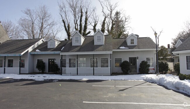

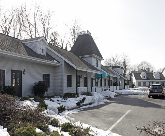
Property Detail
313 3Rd St
Nassau County-Suffolk County, NY
BOOK 12214 PAGE 617 BILL 000784
1001-006-00-02-00-023-005
Suffolk
Regionalshoppingcenterormallwithanchorstore
New York
C and X Area of minimal flood hazard, usually depicted on FIRMs as above the 500-year flood level.
23
2024
1.54 AC
2025
Eastern Suffolk
170101
Long Island (New York)
NEARBY LISTINGS FOR SALE OR LEASE
-
-
View all Greenport listings for sale on LoopNet.com
DEMOGRAPHICS near 313 3Rd St
1 mile
3 mile
5 mile
2025 Total Population
4,759
10,984
18,085
2030 Population
4,999
11,558
18,970
Pop Growth 2025-2030
+ 5.04%
+ 5.23%
+ 4.89%
Average Age
44
48
48
2025 Total Households
1,858
4,751
7,837
HH Growth 2025-2030
+ 5.22%
+ 5.35%
+ 4.90%
Median Household Inc
$72,053
$90,354
$103,099
Avg Household Size
2.40
2.20
2.20
2025 Avg HH Vehicles
2.00
2.00
2.00
Median Home Value
$810,495
$823,462
$821,522
Median Year Built
1952
1971
1972
Nearby Places
Map Layers
Map Styles
 Street
 Aerial
Layers
 Traffic
 Biking
Places
Listings with unknown addresses are not visible on the map
- Restaurants
- Banks
- Shops
- Fitness
- Groceries
PUBLIC TRANSPORTATION
COMMUTER RAIL
Greenport Station (Greenport Branch - Long Island Rail Road)
Drive
Walk
Distance
Greenport Station (Greenport Branch - Long Island Rail Road)
1 min
3 min
0.2 mi
Southold Station (Greenport Branch - Long Island Rail Road)
Drive
Walk
Distance
Southold Station (Greenport Branch - Long Island Rail Road)
9 min
4.6 mi
Freight Ports
Port of New Haven
Drive
Walk
Distance
Port of New Haven
167 min
73.0 mi
Nearby Properties
Address
Land Use
TOTAL SIZE
Lot Size
Zoning
Address
Land Use
TOTAL SIZE
Lot Size
Zoning
600 AC
AA
Address
Land Use
TOTAL SIZE
Lot Size
Zoning
33,799 SF
7.53 AC
AA
Address
Land Use
TOTAL SIZE
Lot Size
Zoning
5,695 SF
139.50 AC
AA
Address
Land Use
TOTAL SIZE
Lot Size
Zoning
8,705 SF
138.70 AC
AA
Address
Land Use
TOTAL SIZE
Lot Size
Zoning
77,580 SF
8.33 AC
C
Address
Land Use
TOTAL SIZE
Lot Size
Zoning
9,468 SF
3.20 AC
AA
Address
Land Use
TOTAL SIZE
Lot Size
Zoning
23,354 SF
0.64 AC
AA
Address
Land Use
TOTAL SIZE
Lot Size
Zoning
21,700 SF
7.90 AC
C
Address
Land Use
TOTAL SIZE
Lot Size
Zoning
170 AC
AA
Address
Land Use
TOTAL SIZE
Lot Size
Zoning
2,076 SF
42.20 AC
AA
Address
Land Use
TOTAL SIZE
Lot Size
Zoning
1,396 SF
6.45 AC
AA
Address
Land Use
TOTAL SIZE
Lot Size
Zoning
8.70 AC
AA
Address
Land Use
TOTAL SIZE
Lot Size
Zoning
12,064 SF
7.75 AC
AA
Address
Land Use
TOTAL SIZE
Lot Size
Zoning
Address
Land Use
TOTAL SIZE
Lot Size
Zoning
12,000 SF
5.39 AC
B
Address
Land Use
TOTAL SIZE
Lot Size
Zoning
7,938 SF
0.58 AC
A
Address
Land Use
TOTAL SIZE
Lot Size
Zoning
3.80 AC
A
Address
Land Use
TOTAL SIZE
Lot Size
Zoning
904 SF
20.30 AC
AA
Address
Land Use
TOTAL SIZE
Lot Size
Zoning
4,340 SF
0.88 AC
AA
Address
Land Use
TOTAL SIZE
Lot Size
Zoning
14.25 AC
A
Address
Land Use
TOTAL SIZE
Lot Size
Zoning
1,284 SF
11.38 AC
C
Address
Land Use
TOTAL SIZE
Lot Size
Zoning
3,634 SF
2.29 AC
B
Address
Land Use
TOTAL SIZE
Lot Size
Zoning
8,793 SF
1.29 AC
B1
Address
Land Use
TOTAL SIZE
Lot Size
Zoning
319.50 AC
AA
Address
Land Use
TOTAL SIZE
Lot Size
Zoning
63.60 AC
C
Address
Land Use
TOTAL SIZE
Lot Size
Zoning
2.20 AC
AA
Address
Land Use
TOTAL SIZE
Lot Size
Zoning
2,925 SF
1.40 AC
B
Address
Land Use
TOTAL SIZE
Lot Size
Zoning
11.10 AC
A
Address
Land Use
TOTAL SIZE
Lot Size
Zoning
1,674 SF
10.56 AC
B
Address
Land Use
TOTAL SIZE
Lot Size
Zoning
17.80 AC
A
The World's #1 Commercial Real Estate Marketplace
Connect with us
© 2026 CoStar Group
The information above has been obtained from sources believed reliable. While we do not doubt its accuracy we have not verified it and make no guarantee, warranty or representation about it. It is your responsibility to independently confirm its accuracy and completeness. Any projections, opinions, assumptions, or estimates used are for example only and do not represent the current or future performance of the property. The value of this transaction to you depends on tax and other factors which should be evaluated by your tax, financial, and legal advisors. You and your advisors should conduct a careful, independent investigation of the property to determine to your satisfaction the suitability of the property for your needs.