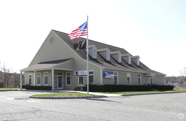
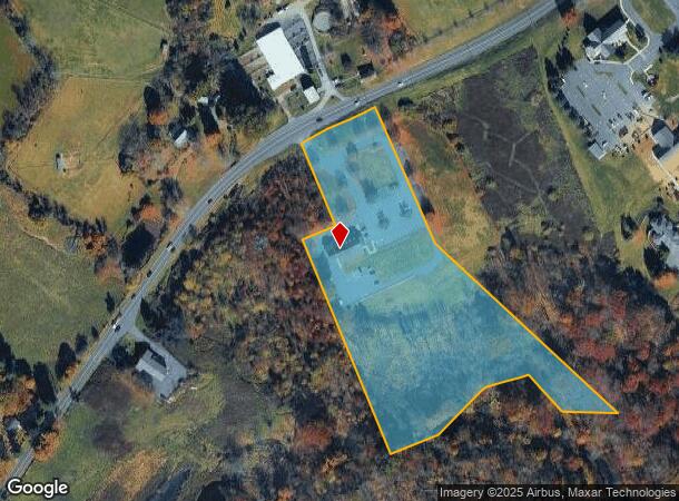
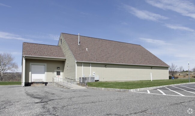
Property Record
Pittstown Rd, Franklin, NJ 07416
Current Lease Availabilities
NEARBY LISTINGS FOR SALE OR LEASE
Property Detail
Pittstown Rd
10-00026-0000-00017-08
Hunterdon
Commercialnec
New Jersey
AE
17.8
34019C0229F
7.36 AC
2024
Hunterdon
2025
Northern New Jersey
372900
Newark, NJ-PA
DEMOGRAPHICS near Pittstown Rd
1 Mile
3 Mile
5 Mile
2024 Total Population
730
6,144
23,345
2029 Population
732
6,147
23,540
Pop Growth 2024-2029
+ 0.27%
+ 0.05%
+ 0.84%
Average Age
45
45
44
2024 Total Households
255
1,989
8,450
HH Growth 2024-2029
+ 0.39%
+ 0.20%
+ 1.05%
Median Household Inc
$160,975
$156,250
$133,214
Avg Household Size
2.80
2.80
2.60
2024 Avg HH Vehicles
3.00
3.00
2.00
Median Home Value
$585,470
$561,721
$471,410
Median Year Built
1979
1979
1981
Nearby Places
- Restaurants
- Banks
- Shops
- Fitness
- Groceries
PUBLIC TRANSPORTATION
COMMUTER RAIL
Annandale (Raritan Valley Line - NJ Transit Commuter Rail (NJ Transit))
DRIVE
WALK
Distance
Annandale (Raritan Valley Line - NJ Transit Commuter Rail (NJ Transit))
12 min
6.6 mi
High Bridge (Raritan Valley Line - NJ Transit Commuter Rail (NJ Transit))
DRIVE
WALK
Distance
High Bridge (Raritan Valley Line - NJ Transit Commuter Rail (NJ Transit))
13 min
7.0 mi
AIRPORT
Trenton Mercer
DRIVE
WALK
Distance
Trenton Mercer
53 min
29.6 mi
Lehigh Valley International
DRIVE
WALK
Distance
Lehigh Valley International
56 min
33.9 mi
Freight Ports
Maher Terminal
DRIVE
WALK
Distance
Maher Terminal
66 min
48.3 mi
Nearby Properties
Address
Land Use
TOTAL SIZE
Lot Size
Zoning
Address
Land Use
TOTAL SIZE
Lot Size
Zoning
3,205 SF
22.05 AC
CR
Address
Land Use
TOTAL SIZE
Lot Size
Zoning
7,680 SF
9.32 AC
CR
Address
Land Use
TOTAL SIZE
Lot Size
Zoning
70 AC
AP
Address
Land Use
TOTAL SIZE
Lot Size
Zoning
24.14 AC
AR-7
Address
Land Use
TOTAL SIZE
Lot Size
Zoning
528 SF
60 AC
Address
Land Use
TOTAL SIZE
Lot Size
Zoning
29,534 SF
81.22 AC
Address
Land Use
TOTAL SIZE
Lot Size
Zoning
2.75 AC
CR
Address
Land Use
TOTAL SIZE
Lot Size
Zoning
11,460 SF
2 AC
RR50
Address
Land Use
TOTAL SIZE
Lot Size
Zoning
1,568 SF
158.63 AC
AR70
Address
Land Use
TOTAL SIZE
Lot Size
Zoning
9,931 SF
1 AC
AR70
Address
Land Use
TOTAL SIZE
Lot Size
Zoning
174.34 AC
RR50
Address
Land Use
TOTAL SIZE
Lot Size
Zoning
2,688 SF
2.10 AC
AP
Address
Land Use
TOTAL SIZE
Lot Size
Zoning
5,698 SF
8.37 AC
VR
Address
Land Use
TOTAL SIZE
Lot Size
Zoning
Address
Land Use
TOTAL SIZE
Lot Size
Zoning
4,222 SF
1 AC
AP
Address
Land Use
TOTAL SIZE
Lot Size
Zoning
8,743 SF
3.50 AC
AR70
Address
Land Use
TOTAL SIZE
Lot Size
Zoning
6,406 SF
2 AC
AP
Address
Land Use
TOTAL SIZE
Lot Size
Zoning
3,124 SF
99.40 AC
RM
Address
Land Use
TOTAL SIZE
Lot Size
Zoning
2.50 AC
AR70
Address
Land Use
TOTAL SIZE
Lot Size
Zoning
7.46 AC
CR
Address
Land Use
TOTAL SIZE
Lot Size
Zoning
6.03 AC
AR70
Address
Land Use
TOTAL SIZE
Lot Size
Zoning
4,966 SF
4.50 AC
AP
Address
Land Use
TOTAL SIZE
Lot Size
Zoning
5,790 SF
1 AC
AP
Address
Land Use
TOTAL SIZE
Lot Size
Zoning
4.53 AC
Address
Land Use
TOTAL SIZE
Lot Size
Zoning
4,890 SF
7.36 AC
VC
Address
Land Use
TOTAL SIZE
Lot Size
Zoning
3,644 SF
1.50 AC
AP
Address
Land Use
TOTAL SIZE
Lot Size
Zoning
5,977 SF
2 AC
RR50
Address
Land Use
TOTAL SIZE
Lot Size
Zoning
6,336 SF
3 AC
Address
Land Use
TOTAL SIZE
Lot Size
Zoning
1,960 SF
1.90 AC
CR
Address
Land Use
TOTAL SIZE
Lot Size
Zoning
4,670 SF
2 AC
RR50
The World's #1 Commercial Real Estate Marketplace
Connect with us
© 2025 CoStar Group
The information above has been obtained from sources believed reliable. While we do not doubt its accuracy we have not verified it and make no guarantee, warranty or representation about it. It is your responsibility to independently confirm its accuracy and completeness. Any projections, opinions, assumptions, or estimates used are for example only and do not represent the current or future performance of the property. The value of this transaction to you depends on tax and other factors which should be evaluated by your tax, financial, and legal advisors. You and your advisors should conduct a careful, independent investigation of the property to determine to your satisfaction the suitability of the property for your needs.