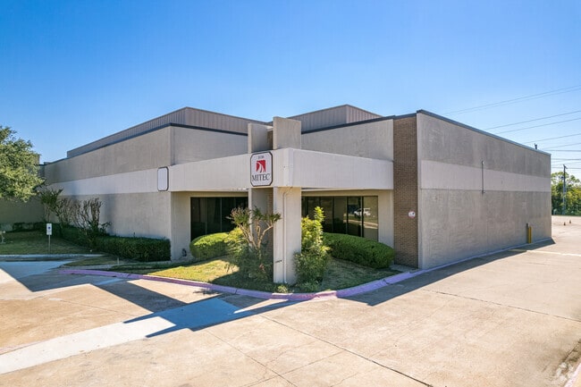
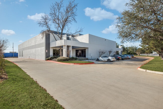
Property Record
3130 Skyway Cir S, Irving, TX 75038
Current Lease Availabilities
NEARBY LISTINGS FOR SALE OR LEASE
Property Detail
3130 Skyway Cir S
Dallas-Fort Worth-Arlington, TX
Walnut Hill Bus Pk Sec 9
325651300D0010000
WALNUT HILL BUS PK SEC 9 BLK D LOT 1 ACS 2.0508 3RD INST INT202200078802 DD03212022 CO-DC 5651300D00100 1CI5651300D
Officebuilding
Dallas
X
Texas
48113C0305L
1
2024
2.05 AC
2025
E DFW Air/Las Colinas
014158
Dallas/Ft Worth
33,510 SF
DEMOGRAPHICS near 3130 Skyway Cir S
1 Mile
3 Mile
5 Mile
2024 Total Population
19,321
105,375
241,009
2029 Population
19,138
103,928
240,699
Pop Growth 2024-2029
(0.95%)
(1.37%)
(0.13%)
Average Age
33
34
35
2024 Total Households
7,822
39,767
93,436
HH Growth 2024-2029
(1.20%)
(1.60%)
(0.28%)
Median Household Inc
$59,427
$67,671
$71,145
Avg Household Size
2.40
2.60
2.50
2024 Avg HH Vehicles
2.00
2.00
2.00
Median Home Value
$296,234
$266,076
$277,992
Median Year Built
1984
1983
1988
Nearby Places
Map Layers
Map Styles
 Street
 Aerial
- Restaurants
- Banks
- Shops
- Fitness
- Groceries
PUBLIC TRANSPORTATION
COMMUTER RAIL
West Irving (TRINITY RAILWAY - Dallas Area Rapid Transit (DART), Trinity Railway Express - Dallas Area Rapid Transit (DART))
DRIVE
WALK
Distance
West Irving (TRINITY RAILWAY - Dallas Area Rapid Transit (DART), Trinity Railway Express - Dallas Area Rapid Transit (DART))
10 min
6.2 mi
East Tex Yard Limit (TRINITY RAILWAY - Dallas Area Rapid Transit (DART))
DRIVE
WALK
Distance
East Tex Yard Limit (TRINITY RAILWAY - Dallas Area Rapid Transit (DART))
11 min
7.6 mi
AIRPORT
Dallas-Fort Worth International
DRIVE
WALK
Distance
Dallas-Fort Worth International
14 min
7.0 mi
Dallas Love Field
DRIVE
WALK
Distance
Dallas Love Field
22 min
14.3 mi
Freight Ports
Port of Shreveport
DRIVE
WALK
Distance
Port of Shreveport
230 min
214.1 mi
Nearby Properties
Address
Land Use
TOTAL SIZE
Lot Size
Zoning
Address
Land Use
TOTAL SIZE
Lot Size
Zoning
12,780,691 SF
0.08 AC
Z392
Address
Land Use
TOTAL SIZE
Lot Size
Zoning
1,066,464 SF
4.10 AC
Z392
Address
Land Use
TOTAL SIZE
Lot Size
Zoning
2,496,382 SF
256.13 AC
Z392
Address
Land Use
TOTAL SIZE
Lot Size
Zoning
962,320 SF
23.81 AC
Z198
Address
Land Use
TOTAL SIZE
Lot Size
Zoning
1,520,000 SF
34.76 AC
Z243
Address
Land Use
TOTAL SIZE
Lot Size
Zoning
850,390 SF
16.12 AC
Address
Land Use
TOTAL SIZE
Lot Size
Zoning
565,728 SF
21.07 AC
Address
Land Use
TOTAL SIZE
Lot Size
Zoning
346,000 SF
15.52 AC
Z198
Address
Land Use
TOTAL SIZE
Lot Size
Zoning
1,763,184 SF
11.25 AC
Z393
Address
Land Use
TOTAL SIZE
Lot Size
Zoning
379,000 SF
9.81 AC
Z243
Address
Land Use
TOTAL SIZE
Lot Size
Zoning
674,817 SF
15.35 AC
Z84
Address
Land Use
TOTAL SIZE
Lot Size
Zoning
631,947 SF
11.95 AC
Z393
Address
Land Use
TOTAL SIZE
Lot Size
Zoning
689,004 SF
25.23 AC
Z243
Address
Land Use
TOTAL SIZE
Lot Size
Zoning
735,258 SF
4.83 AC
Z392
Address
Land Use
TOTAL SIZE
Lot Size
Zoning
1,144,971 SF
19.43 AC
Z84
Address
Land Use
TOTAL SIZE
Lot Size
Zoning
729,870 SF
24.42 AC
Z393
Address
Land Use
TOTAL SIZE
Lot Size
Zoning
464,996 SF
18.43 AC
SP2
Address
Land Use
TOTAL SIZE
Lot Size
Zoning
724,643 SF
5.15 AC
Z243
Address
Land Use
TOTAL SIZE
Lot Size
Zoning
347,008 SF
9.54 AC
Z57
Address
Land Use
TOTAL SIZE
Lot Size
Zoning
1,219,380 SF
16.01 AC
Z243
Address
Land Use
TOTAL SIZE
Lot Size
Zoning
457,322 SF
22.98 AC
Z243
Address
Land Use
TOTAL SIZE
Lot Size
Zoning
543,965 SF
8.02 AC
Z323
Address
Land Use
TOTAL SIZE
Lot Size
Zoning
717,650 SF
28.32 AC
Z243
Address
Land Use
TOTAL SIZE
Lot Size
Zoning
588,626 SF
6.55 AC
Z84
Address
Land Use
TOTAL SIZE
Lot Size
Zoning
505,823 SF
29.64 AC
Z113
Address
Land Use
TOTAL SIZE
Lot Size
Zoning
616,333 SF
6.32 AC
Z393
Address
Land Use
TOTAL SIZE
Lot Size
Zoning
1,793,119 SF
85 AC
Address
Land Use
TOTAL SIZE
Lot Size
Zoning
573,495 SF
30.30 AC
Z243
Address
Land Use
TOTAL SIZE
Lot Size
Zoning
476,330 SF
25.63 AC
Z176
Address
Land Use
TOTAL SIZE
Lot Size
Zoning
949,876 SF
8.39 AC
Z57
The World's #1 Commercial Real Estate Marketplace
Connect with us
© 2025 CoStar Group
The information above has been obtained from sources believed reliable. While we do not doubt its accuracy we have not verified it and make no guarantee, warranty or representation about it. It is your responsibility to independently confirm its accuracy and completeness. Any projections, opinions, assumptions, or estimates used are for example only and do not represent the current or future performance of the property. The value of this transaction to you depends on tax and other factors which should be evaluated by your tax, financial, and legal advisors. You and your advisors should conduct a careful, independent investigation of the property to determine to your satisfaction the suitability of the property for your needs.