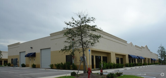
Property Record
3130 Cooper St, Punta Gorda, FL 33950

NEARBY LISTINGS FOR SALE OR LEASE
Property Detail
3130 Cooper St
412317701055
Cooper Street Commerce Park Comm Condo P
Municipalproperty
COOPER STREET COMMERCE PARK COMM CONDO PHASE 1 UNITS 101 102 103 104 105 106 110 201 202 215 216; PHASE 2 UNITS 401 402 403 404 405 406 407 408 409 & 410; PHASE 3 UNITS 501 502 503 504 505 506 507 508 509 510 511 512 513 514 515 & 516; PHASE 4 U
AE
Charlotte
12015C0241G
Florida
0
16.78 AC
2025
Charlotte County
010302
Southwest Florida
54,114 SF
Punta Gorda, FL
DEMOGRAPHICS near 3130 Cooper St
1 Mile
3 Mile
5 Mile
2024 Total Population
4,026
28,304
43,675
2029 Population
4,803
34,125
52,602
Pop Growth 2024-2029
+ 19.30%
+ 20.57%
+ 20.44%
Average Age
57
59
57
2024 Total Households
2,058
14,068
21,510
HH Growth 2024-2029
+ 19.19%
+ 20.78%
+ 20.70%
Median Household Inc
$51,448
$63,994
$60,129
Avg Household Size
1.90
1.90
2.00
2024 Avg HH Vehicles
2.00
2.00
2.00
Median Home Value
$262,910
$395,734
$331,042
Median Year Built
1996
1994
1992
Nearby Places
Map Layers
Map Styles
 Street
 Aerial
- Restaurants
- Banks
- Shops
- Fitness
- Groceries
PUBLIC TRANSPORTATION
AIRPORT
Punta Gorda
DRIVE
WALK
Distance
Punta Gorda
9 min
3.7 mi
Southwest Florida International
DRIVE
WALK
Distance
Southwest Florida International
49 min
36.4 mi
Nearby Properties
Address
Land Use
TOTAL SIZE
Lot Size
Zoning
Address
Land Use
TOTAL SIZE
Lot Size
Zoning
349,844 SF
78.47 AC
P
Address
Land Use
TOTAL SIZE
Lot Size
Zoning
164,121 SF
44.20 AC
ECAP
Address
Land Use
TOTAL SIZE
Lot Size
Zoning
77,154 SF
10.30 AC
CC
Address
Land Use
TOTAL SIZE
Lot Size
Zoning
161,439 SF
171 AC
RE1
Address
Land Use
TOTAL SIZE
Lot Size
Zoning
265,949 SF
22.80 AC
PD-CC
Address
Land Use
TOTAL SIZE
Lot Size
Zoning
253,440 SF
30.47 AC
ECAP
Address
Land Use
TOTAL SIZE
Lot Size
Zoning
378,000 SF
29.24 AC
ECAP
Address
Land Use
TOTAL SIZE
Lot Size
Zoning
345,043 SF
33.12 AC
ECAP
Address
Land Use
TOTAL SIZE
Lot Size
Zoning
47,443 SF
7.94 AC
CC
Address
Land Use
TOTAL SIZE
Lot Size
Zoning
62,415 SF
281.65 AC
ECAP
Address
Land Use
TOTAL SIZE
Lot Size
Zoning
114,417 SF
4.36 AC
GM-15
Address
Land Use
TOTAL SIZE
Lot Size
Zoning
15,253 SF
13.27 AC
P
Address
Land Use
TOTAL SIZE
Lot Size
Zoning
198,916 SF
25.79 AC
HC
Address
Land Use
TOTAL SIZE
Lot Size
Zoning
208,560 SF
36.69 AC
PD-GM
Address
Land Use
TOTAL SIZE
Lot Size
Zoning
385,350 SF
374.81 AC
ECAP
Address
Land Use
TOTAL SIZE
Lot Size
Zoning
134,308 SF
16 AC
RSF3.5
Address
Land Use
TOTAL SIZE
Lot Size
Zoning
142,812 SF
7.89 AC
HC
Address
Land Use
TOTAL SIZE
Lot Size
Zoning
6,313 SF
15.49 AC
P
Address
Land Use
TOTAL SIZE
Lot Size
Zoning
73,095 SF
5 AC
NC
Address
Land Use
TOTAL SIZE
Lot Size
Zoning
44,185 SF
1.22 AC
CC
Address
Land Use
TOTAL SIZE
Lot Size
Zoning
25,356 SF
1.40 AC
CC
Address
Land Use
TOTAL SIZE
Lot Size
Zoning
96,845 SF
17.62 AC
HC
Address
Land Use
TOTAL SIZE
Lot Size
Zoning
8,406 SF
31.48 AC
ECAP
Address
Land Use
TOTAL SIZE
Lot Size
Zoning
82,379 SF
0.88 AC
CC
Address
Land Use
TOTAL SIZE
Lot Size
Zoning
12,159 SF
0.56 AC
CC
Address
Land Use
TOTAL SIZE
Lot Size
Zoning
24,880 SF
84.50 AC
PKR
Address
Land Use
TOTAL SIZE
Lot Size
Zoning
43,755 SF
8.19 AC
CC
Address
Land Use
TOTAL SIZE
Lot Size
Zoning
30,472 SF
3.19 AC
NR-10
Address
Land Use
TOTAL SIZE
Lot Size
Zoning
30,940 SF
0.42 AC
NC
Address
Land Use
TOTAL SIZE
Lot Size
Zoning
68,492 SF
6.38 AC
HC
The World's #1 Commercial Real Estate Marketplace
Connect with us
© 2026 CoStar Group
The information above has been obtained from sources believed reliable. While we do not doubt its accuracy we have not verified it and make no guarantee, warranty or representation about it. It is your responsibility to independently confirm its accuracy and completeness. Any projections, opinions, assumptions, or estimates used are for example only and do not represent the current or future performance of the property. The value of this transaction to you depends on tax and other factors which should be evaluated by your tax, financial, and legal advisors. You and your advisors should conduct a careful, independent investigation of the property to determine to your satisfaction the suitability of the property for your needs.