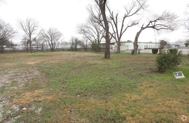
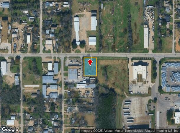
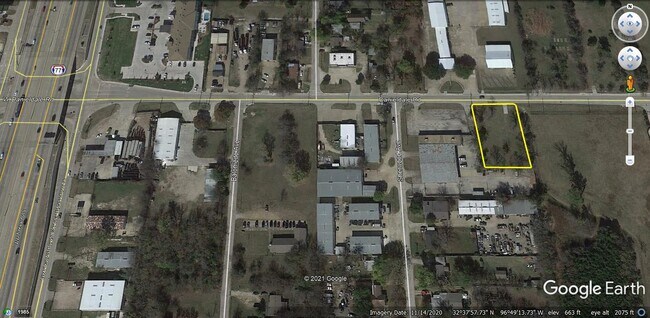
Property Record
3130 Danieldale Rd, Lancaster, TX 75134
NEARBY LISTINGS FOR SALE OR LEASE
Property Detail
3130 Danieldale Rd
Dallas-Fort Worth-Arlington, TX
Brownlee Park
60018500050340000
BROWNLEE PARK BLK E LT 34 INT202500025450 DD02072025 CO-DC 0185000503400 23601850005
Commercialacreage
Dallas
X
Texas
48113C0490K
34
2024
0.63 AC
2025
Southwest Dallas
016709
Dallas/Ft Worth
DEMOGRAPHICS near 3130 Danieldale Rd
1 Mile
3 Mile
5 Mile
2024 Total Population
2,084
67,179
198,819
2029 Population
2,071
66,131
197,010
Pop Growth 2024-2029
(0.62%)
(1.56%)
(0.91%)
Average Age
34
37
37
2024 Total Households
652
22,751
69,080
HH Growth 2024-2029
(0.92%)
(1.83%)
(1.15%)
Median Household Inc
$45,305
$54,037
$49,567
Avg Household Size
3.20
2.90
2.80
2024 Avg HH Vehicles
2.00
2.00
2.00
Median Home Value
$214,238
$180,783
$184,714
Median Year Built
1991
1984
1982
Nearby Places
Map Layers
Map Styles
 Street
 Aerial
- Restaurants
- Banks
- Shops
- Fitness
- Groceries
PUBLIC TRANSPORTATION
AIRPORT
Dallas Love Field
DRIVE
WALK
Distance
Dallas Love Field
27 min
16.8 mi
Dallas-Fort Worth International
DRIVE
WALK
Distance
Dallas-Fort Worth International
40 min
30.5 mi
SALE & LEASE HISTORY
LISTING DATE
SALE/LEASE

Jul 19, 2021
For Sale
Jul 13, 2017
For Sale
Nearby Properties
Address
Land Use
TOTAL SIZE
Lot Size
Zoning
Address
Land Use
TOTAL SIZE
Lot Size
Zoning
1,283,264 SF
78.52 AC
Z04
Address
Land Use
TOTAL SIZE
Lot Size
Zoning
1,316,325 SF
54.36 AC
Z111
Address
Land Use
TOTAL SIZE
Lot Size
Zoning
1,200,000 SF
60.01 AC
Z125
Address
Land Use
TOTAL SIZE
Lot Size
Zoning
1,126,320 SF
63.41 AC
Z111
Address
Land Use
TOTAL SIZE
Lot Size
Zoning
1,167,500 SF
46.04 AC
Z06
Address
Land Use
TOTAL SIZE
Lot Size
Zoning
1,015,340 SF
55.63 AC
Z239
Address
Land Use
TOTAL SIZE
Lot Size
Zoning
951,480 SF
50.63 AC
Z109
Address
Land Use
TOTAL SIZE
Lot Size
Zoning
948,392 SF
50.80 AC
Z109
Address
Land Use
TOTAL SIZE
Lot Size
Zoning
917,700 SF
44.27 AC
Z125
Address
Land Use
TOTAL SIZE
Lot Size
Zoning
900,000 SF
50.76 AC
Z04
Address
Land Use
TOTAL SIZE
Lot Size
Zoning
1,108,100 SF
65.25 AC
Z125
Address
Land Use
TOTAL SIZE
Lot Size
Zoning
872,640 SF
46.97 AC
Z125
Address
Land Use
TOTAL SIZE
Lot Size
Zoning
823,000 SF
45.10 AC
Z298
Address
Land Use
TOTAL SIZE
Lot Size
Zoning
713,000 SF
52.25 AC
Z125
Address
Land Use
TOTAL SIZE
Lot Size
Zoning
554,600 SF
50.31 AC
Z298
Address
Land Use
TOTAL SIZE
Lot Size
Zoning
550,800 SF
26.52 AC
Z239
Address
Land Use
TOTAL SIZE
Lot Size
Zoning
662,230 SF
38.49 AC
Z248
Address
Land Use
TOTAL SIZE
Lot Size
Zoning
660,400 SF
35.93 AC
Z125
Address
Land Use
TOTAL SIZE
Lot Size
Zoning
659,523 SF
35.33 AC
Z04
Address
Land Use
TOTAL SIZE
Lot Size
Zoning
595,148 SF
34.96 AC
Z39
Address
Land Use
TOTAL SIZE
Lot Size
Zoning
627,000 SF
37.09 AC
Z125
Address
Land Use
TOTAL SIZE
Lot Size
Zoning
123,880 SF
16.80 AC
Z236
Address
Land Use
TOTAL SIZE
Lot Size
Zoning
610,806 SF
33.66 AC
Z125
Address
Land Use
TOTAL SIZE
Lot Size
Zoning
610,806 SF
34.20 AC
Z125
Address
Land Use
TOTAL SIZE
Lot Size
Zoning
590,200 SF
31.83 AC
Z04
Address
Land Use
TOTAL SIZE
Lot Size
Zoning
507,318 SF
28.40 AC
Z111
Address
Land Use
TOTAL SIZE
Lot Size
Zoning
552,200 SF
41.36 AC
Z109
Address
Land Use
TOTAL SIZE
Lot Size
Zoning
610,669 SF
41.65 AC
Z125
Address
Land Use
TOTAL SIZE
Lot Size
Zoning
489,310 SF
33.91 AC
Z111
Address
Land Use
TOTAL SIZE
Lot Size
Zoning
531,254 SF
33.40 AC
Z06
The World's #1 Commercial Real Estate Marketplace
Connect with us
© 2026 CoStar Group
The information above has been obtained from sources believed reliable. While we do not doubt its accuracy we have not verified it and make no guarantee, warranty or representation about it. It is your responsibility to independently confirm its accuracy and completeness. Any projections, opinions, assumptions, or estimates used are for example only and do not represent the current or future performance of the property. The value of this transaction to you depends on tax and other factors which should be evaluated by your tax, financial, and legal advisors. You and your advisors should conduct a careful, independent investigation of the property to determine to your satisfaction the suitability of the property for your needs.