Property Record
3130 E 5Th St, Tyler, TX 75701
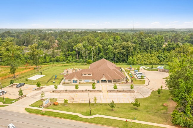

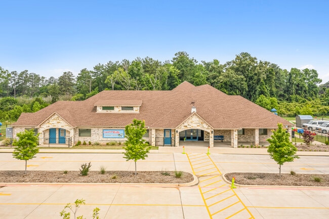

Property Detail
3130 E 5Th St
Tyler, TX
BENDER ADDNBLOCK 1426 LOT 9A
1-50000-1426-00-009010
Smith
Daycare
Texas
B and X Area of moderate flood hazard, usually the area between the limits of the 100-year and 500-year floods.
9a
2025
3.80 AC
2025
Tyler
001300
Other Market Areas
11,033 SF
NEARBY LISTINGS FOR SALE OR LEASE
DEMOGRAPHICS near 3130 E 5Th St
1 mile
3 mile
5 mile
2025 Total Population
7,682
47,347
103,031
2030 Population
8,162
49,906
108,504
Pop Growth 2025-2030
+ 6.25%
+ 5.40%
+ 5.31%
Average Age
35
37
38
2025 Total Households
2,981
18,287
39,535
HH Growth 2025-2030
+ 6.31%
+ 5.03%
+ 4.81%
Median Household Inc
$67,618
$64,160
$62,190
Avg Household Size
2.30
2.40
2.40
2025 Avg HH Vehicles
2.00
2.00
2.00
Median Home Value
$224,182
$248,584
$222,653
Median Year Built
1977
1974
1976
Nearby Places
Map Layers
Map Styles
 Street
 Aerial
Layers
 Traffic
 Biking
Places
Listings with unknown addresses are not visible on the map
- Restaurants
- Banks
- Shops
- Fitness
- Groceries
PUBLIC TRANSPORTATION
AIRPORT
Tyler Pounds Regional
Drive
Walk
Distance
Tyler Pounds Regional
20 min
11.4 mi
Freight Ports
Port of Shreveport
Drive
Walk
Distance
Port of Shreveport
121 min
107.2 mi
SALE & LEASE HISTORY
LISTING DATE
SALE/LEASE

Jun 06, 2023
For Sale
Jan 08, 2024
For Sale
Nearby Properties
Address
Land Use
TOTAL SIZE
Lot Size
Zoning
Address
Land Use
TOTAL SIZE
Lot Size
Zoning
14,000 SF
144.13 AC
M2
Address
Land Use
TOTAL SIZE
Lot Size
Zoning
12.64 AC
Address
Land Use
TOTAL SIZE
Lot Size
Zoning
22,500 SF
214.44 AC
R1A
Address
Land Use
TOTAL SIZE
Lot Size
Zoning
503,620 SF
11.42 AC
Address
Land Use
TOTAL SIZE
Lot Size
Zoning
1.47 AC
RMF
Address
Land Use
TOTAL SIZE
Lot Size
Zoning
13,067 SF
151.32 AC
M2
Address
Land Use
TOTAL SIZE
Lot Size
Zoning
9.98 AC
Address
Land Use
TOTAL SIZE
Lot Size
Zoning
18.37 AC
R1A
Address
Land Use
TOTAL SIZE
Lot Size
Zoning
168,390 SF
7.51 AC
Address
Land Use
TOTAL SIZE
Lot Size
Zoning
Address
Land Use
TOTAL SIZE
Lot Size
Zoning
Address
Land Use
TOTAL SIZE
Lot Size
Zoning
37.07 AC
Address
Land Use
TOTAL SIZE
Lot Size
Zoning
16.53 AC
Address
Land Use
TOTAL SIZE
Lot Size
Zoning
1.78 AC
DBAC
Address
Land Use
TOTAL SIZE
Lot Size
Zoning
Address
Land Use
TOTAL SIZE
Lot Size
Zoning
448,500 SF
2.90 AC
INT
Address
Land Use
TOTAL SIZE
Lot Size
Zoning
238,658 SF
1.97 AC
INT
Address
Land Use
TOTAL SIZE
Lot Size
Zoning
25 AC
INT
Address
Land Use
TOTAL SIZE
Lot Size
Zoning
213,323 SF
1.21 AC
Address
Land Use
TOTAL SIZE
Lot Size
Zoning
2.40 AC
Address
Land Use
TOTAL SIZE
Lot Size
Zoning
2,592 SF
9.20 AC
PMF
Address
Land Use
TOTAL SIZE
Lot Size
Zoning
Address
Land Use
TOTAL SIZE
Lot Size
Zoning
300 SF
11.17 AC
RMF
Address
Land Use
TOTAL SIZE
Lot Size
Zoning
12,810 SF
12.07 AC
R1A
Address
Land Use
TOTAL SIZE
Lot Size
Zoning
20,071 SF
7.43 AC
Address
Land Use
TOTAL SIZE
Lot Size
Zoning
37,536 SF
16.81 AC
RMF
Address
Land Use
TOTAL SIZE
Lot Size
Zoning
3,385 SF
10.50 AC
R1A
Address
Land Use
TOTAL SIZE
Lot Size
Zoning
8,279 SF
14.06 AC
RMF
Address
Land Use
TOTAL SIZE
Lot Size
Zoning
14,752 SF
9.64 AC
RMF
Address
Land Use
TOTAL SIZE
Lot Size
Zoning
111,030 SF
1.02 AC
The World's #1 Commercial Real Estate Marketplace
Connect with us
© 2026 CoStar Group
The information above has been obtained from sources believed reliable. While we do not doubt its accuracy we have not verified it and make no guarantee, warranty or representation about it. It is your responsibility to independently confirm its accuracy and completeness. Any projections, opinions, assumptions, or estimates used are for example only and do not represent the current or future performance of the property. The value of this transaction to you depends on tax and other factors which should be evaluated by your tax, financial, and legal advisors. You and your advisors should conduct a careful, independent investigation of the property to determine to your satisfaction the suitability of the property for your needs.