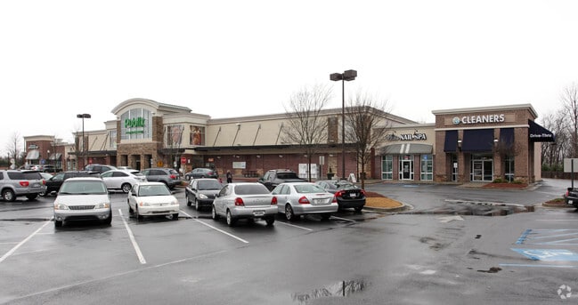
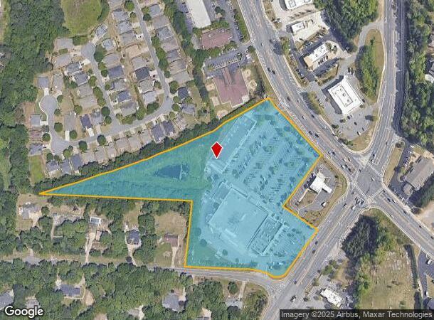
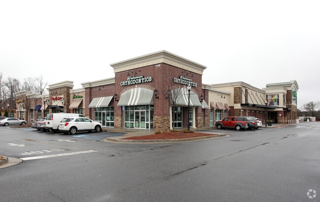
Property Record
3130 Mathis Airport Pkwy, Suwanee, GA 30024

NEARBY LISTINGS FOR SALE OR LEASE
Property Detail
3130 Mathis Airport Pkwy
Atlanta-Sandy Springs-Roswell, GA
Village Shoppes/Windermere
136-023
2-1 923-924
Regionalshoppingcenterormallwithanchorstore
Forsyth
X
Georgia
13117C0232F
923
2024
10.57 AC
2025
Cumming/Forsyth Cnty
130614
Atlanta
2,277 SF
DEMOGRAPHICS near 3130 Mathis Airport Pkwy
1 Mile
3 Mile
5 Mile
2024 Total Population
6,414
61,689
162,516
2029 Population
7,347
70,911
180,536
Pop Growth 2024-2029
+ 14.55%
+ 14.95%
+ 11.09%
Average Age
38
38
38
2024 Total Households
1,906
19,150
52,124
HH Growth 2024-2029
+ 14.59%
+ 15.03%
+ 11.24%
Median Household Inc
$166,445
$161,135
$146,925
Avg Household Size
3.40
3.20
3.10
2024 Avg HH Vehicles
3.00
2.00
2.00
Median Home Value
$634,541
$517,657
$486,221
Median Year Built
2000
2003
2002
Nearby Places
- Restaurants
- Banks
- Shops
- Fitness
- Groceries
SALE & LEASE HISTORY
LISTING DATE
SALE/LEASE

Sep 25, 2016
For Lease
Apr 03, 2023
For Lease
Nearby Properties
Address
Land Use
TOTAL SIZE
Lot Size
Zoning
Address
Land Use
TOTAL SIZE
Lot Size
Zoning
424,176 SF
59.62 AC
R3
Address
Land Use
TOTAL SIZE
Lot Size
Zoning
321,116 SF
17.06 AC
CBD
Address
Land Use
TOTAL SIZE
Lot Size
Zoning
47,721 SF
12.99 AC
CBD
Address
Land Use
TOTAL SIZE
Lot Size
Zoning
99,600 SF
91.27 AC
CR1
Address
Land Use
TOTAL SIZE
Lot Size
Zoning
291,232 SF
71.66 AC
RES3
Address
Land Use
TOTAL SIZE
Lot Size
Zoning
222,893 SF
103.13 AC
M1
Address
Land Use
TOTAL SIZE
Lot Size
Zoning
186,015 SF
13.72 AC
MP
Address
Land Use
TOTAL SIZE
Lot Size
Zoning
60,235 SF
11.94 AC
CBD
Address
Land Use
TOTAL SIZE
Lot Size
Zoning
192,316 SF
51.53 AC
A1
Address
Land Use
TOTAL SIZE
Lot Size
Zoning
14,880 SF
16.51 AC
CBD
Address
Land Use
TOTAL SIZE
Lot Size
Zoning
101,510 SF
15.45 AC
CBD
Address
Land Use
TOTAL SIZE
Lot Size
Zoning
45,603 SF
8.36 AC
CBD
Address
Land Use
TOTAL SIZE
Lot Size
Zoning
117,036 SF
13.62 AC
CBD
Address
Land Use
TOTAL SIZE
Lot Size
Zoning
136,660 SF
21.47 AC
M1
Address
Land Use
TOTAL SIZE
Lot Size
Zoning
2,376 SF
68.90 AC
A1
Address
Land Use
TOTAL SIZE
Lot Size
Zoning
73,022 SF
6.57 AC
CBD
Address
Land Use
TOTAL SIZE
Lot Size
Zoning
3,366 SF
20.07 AC
PUD
Address
Land Use
TOTAL SIZE
Lot Size
Zoning
126,920 SF
12.25 AC
M1
Address
Land Use
TOTAL SIZE
Lot Size
Zoning
127,096 SF
7.25 AC
M1
Address
Land Use
TOTAL SIZE
Lot Size
Zoning
98,593 SF
34.52 AC
R2R
Address
Land Use
TOTAL SIZE
Lot Size
Zoning
99,972 SF
5.61 AC
CBD
Address
Land Use
TOTAL SIZE
Lot Size
Zoning
772.94 AC
MINE
Address
Land Use
TOTAL SIZE
Lot Size
Zoning
18,344 SF
58.35 AC
R2R
Address
Land Use
TOTAL SIZE
Lot Size
Zoning
67,580 SF
10.60 AC
CBD
Address
Land Use
TOTAL SIZE
Lot Size
Zoning
88,534 SF
7.15 AC
CBD
Address
Land Use
TOTAL SIZE
Lot Size
Zoning
135,626 SF
8.66 AC
M1
Address
Land Use
TOTAL SIZE
Lot Size
Zoning
72,567 SF
5.60 AC
HB
Address
Land Use
TOTAL SIZE
Lot Size
Zoning
133,842 SF
27.23 AC
CR1
Address
Land Use
TOTAL SIZE
Lot Size
Zoning
168,330 SF
52.73 AC
R1
The World's #1 Commercial Real Estate Marketplace
Connect with us
© 2025 CoStar Group
The information above has been obtained from sources believed reliable. While we do not doubt its accuracy we have not verified it and make no guarantee, warranty or representation about it. It is your responsibility to independently confirm its accuracy and completeness. Any projections, opinions, assumptions, or estimates used are for example only and do not represent the current or future performance of the property. The value of this transaction to you depends on tax and other factors which should be evaluated by your tax, financial, and legal advisors. You and your advisors should conduct a careful, independent investigation of the property to determine to your satisfaction the suitability of the property for your needs.