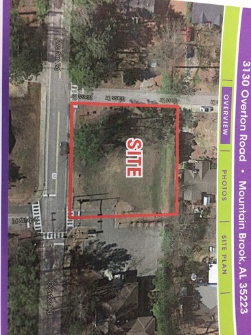
Property Record
3130 Overton Rd, Mountain Brk, AL 35223


NEARBY LISTINGS FOR SALE OR LEASE
Property Detail
3130 Overton Rd
Birmingham-Hoover, AL
Glasss 3Rd Add Am28-15-4
28-00-15-4-005-002.000
LOT 1 OF A RESUR OF LOTS 1 & 2 & LOTS 36 & 37 BLK 3 GLASSS 3RD ADD TO NEW MERKLE PB 207 PG 55 & AMENDED PB 208 PG 57
Vacantlandnec
Jefferson
X
Alabama
01117C0080F
1
2023
0.38 AC
2024
Hwy 280/Jefferson County
010804
Birmingham
DEMOGRAPHICS near 3130 Overton Rd
1 Mile
3 Mile
5 Mile
2024 Total Population
7,143
39,440
147,046
2029 Population
6,907
38,291
145,726
Pop Growth 2024-2029
(3.30%)
(2.91%)
(0.90%)
Average Age
40
39
38
2024 Total Households
3,077
15,690
63,121
HH Growth 2024-2029
(3.44%)
(3.06%)
(0.79%)
Median Household Inc
$105,965
$111,177
$86,001
Avg Household Size
2.30
2.40
2.20
2024 Avg HH Vehicles
2.00
2.00
2.00
Median Home Value
$434,750
$565,384
$424,992
Median Year Built
1976
1978
1976
Nearby Places
Map Layers
Map Styles
 Street
 Aerial
- Restaurants
- Banks
- Shops
- Fitness
- Groceries
PUBLIC TRANSPORTATION
AIRPORT
Birmingham-Shuttlesworth International
DRIVE
WALK
Distance
Birmingham-Shuttlesworth International
20 min
11.2 mi
SALE & LEASE HISTORY
LISTING DATE
SALE/LEASE

Oct 11, 2019
For Sale
Nearby Properties
Address
Land Use
TOTAL SIZE
Lot Size
Zoning
Address
Land Use
TOTAL SIZE
Lot Size
Zoning
200,418 SF
6.50 AC
C1
Address
Land Use
TOTAL SIZE
Lot Size
Zoning
261,311 SF
20.85 AC
C1
Address
Land Use
TOTAL SIZE
Lot Size
Zoning
212,615 SF
19.66 AC
B-2
Address
Land Use
TOTAL SIZE
Lot Size
Zoning
45,868 SF
6.80 AC
CP Y
Address
Land Use
TOTAL SIZE
Lot Size
Zoning
500,279 SF
52.57 AC
B2
Address
Land Use
TOTAL SIZE
Lot Size
Zoning
154,474 SF
12.50 AC
R-D
Address
Land Use
TOTAL SIZE
Lot Size
Zoning
140,853 SF
27 AC
B-2
Address
Land Use
TOTAL SIZE
Lot Size
Zoning
153,413 SF
6.35 AC
C1
Address
Land Use
TOTAL SIZE
Lot Size
Zoning
6 AC
C-1
Address
Land Use
TOTAL SIZE
Lot Size
Zoning
169,501 SF
18 AC
E-2
Address
Land Use
TOTAL SIZE
Lot Size
Zoning
81,807 SF
6.30 AC
C1
Address
Land Use
TOTAL SIZE
Lot Size
Zoning
136,498 SF
11 AC
C1
Address
Land Use
TOTAL SIZE
Lot Size
Zoning
235,082 SF
26.10 AC
C1
Address
Land Use
TOTAL SIZE
Lot Size
Zoning
102,373 SF
12.33 AC
R1-E
Address
Land Use
TOTAL SIZE
Lot Size
Zoning
51,699 SF
1.31 AC
PCD-
Address
Land Use
TOTAL SIZE
Lot Size
Zoning
344,434 SF
15.52 AC
R4
Address
Land Use
TOTAL SIZE
Lot Size
Zoning
239,213 SF
17 AC
C1
Address
Land Use
TOTAL SIZE
Lot Size
Zoning
259,316 SF
30 AC
PUD
Address
Land Use
TOTAL SIZE
Lot Size
Zoning
329,064 SF
9 AC
I3
Address
Land Use
TOTAL SIZE
Lot Size
Zoning
321,157 SF
33 AC
C
Address
Land Use
TOTAL SIZE
Lot Size
Zoning
62,543 SF
1.78 AC
R-D
Address
Land Use
TOTAL SIZE
Lot Size
Zoning
59,454 SF
4.21 AC
C1
Address
Land Use
TOTAL SIZE
Lot Size
Zoning
361,937 SF
22 AC
R4
Address
Land Use
TOTAL SIZE
Lot Size
Zoning
125,165 SF
8.07 AC
CP
Address
Land Use
TOTAL SIZE
Lot Size
Zoning
331,413 SF
14.46 AC
R6
Address
Land Use
TOTAL SIZE
Lot Size
Zoning
62,516 SF
1.37 AC
I3
Address
Land Use
TOTAL SIZE
Lot Size
Zoning
89,134 SF
6.50 AC
C-1
Address
Land Use
TOTAL SIZE
Lot Size
Zoning
58,463 SF
11 AC
C1
Address
Land Use
TOTAL SIZE
Lot Size
Zoning
5,506 SF
17.36 AC
Address
Land Use
TOTAL SIZE
Lot Size
Zoning
97,764 SF
14.20 AC
C1
The World's #1 Commercial Real Estate Marketplace
Connect with us
© 2026 CoStar Group
The information above has been obtained from sources believed reliable. While we do not doubt its accuracy we have not verified it and make no guarantee, warranty or representation about it. It is your responsibility to independently confirm its accuracy and completeness. Any projections, opinions, assumptions, or estimates used are for example only and do not represent the current or future performance of the property. The value of this transaction to you depends on tax and other factors which should be evaluated by your tax, financial, and legal advisors. You and your advisors should conduct a careful, independent investigation of the property to determine to your satisfaction the suitability of the property for your needs.