Property Record
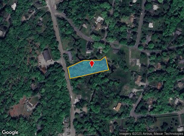
3130 Route 9, Cold Spring, NY 10516
NEARBY LISTINGS FOR SALE OR LEASE
-
-
View all Cold Spring listings for sale on LoopNet.com
Property Detail
3130 Route 9
372689-027-012-0001-007-000-0000
Putnam
Vacantlandnec
New York
AE
7.000
36079C0083E
1.09 AC
2024
Carmel
2024
Westchester/So Connecticut
010600
Dutchess County-Putnam County, NY
DEMOGRAPHICS near 3130 Route 9
1 Mile
3 Mile
5 Mile
2024 Total Population
974
3,703
30,494
2029 Population
984
3,728
30,685
Pop Growth 2024-2029
+ 1.03%
+ 0.68%
+ 0.63%
Average Age
47
46
41
2024 Total Households
393
1,508
11,574
HH Growth 2024-2029
+ 1.02%
+ 0.73%
+ 0.34%
Median Household Inc
$131,597
$122,197
$98,071
Avg Household Size
2.40
2.40
2.30
2024 Avg HH Vehicles
2.00
2.00
2.00
Median Home Value
$665,730
$632,837
$430,956
Median Year Built
1978
1972
1963
Nearby Places
Map Layers
Map Styles
 Street
 Aerial
- Restaurants
- Banks
- Shops
- Fitness
- Groceries
PUBLIC TRANSPORTATION
COMMUTER RAIL
Cold Spring Station (Hudson Line - Metro-North Commuter Railroad Company (Metro-North))
DRIVE
WALK
Distance
Cold Spring Station (Hudson Line - Metro-North Commuter Railroad Company (Metro-North))
9 min
4.7 mi
Breakneck Ridge Station (Hudson Line - Metro-North Commuter Railroad Company (Metro-North))
DRIVE
WALK
Distance
Breakneck Ridge Station (Hudson Line - Metro-North Commuter Railroad Company (Metro-North))
10 min
6.7 mi
AIRPORT
New York Stewart International
DRIVE
WALK
Distance
New York Stewart International
29 min
19.8 mi
Westchester County
DRIVE
WALK
Distance
Westchester County
56 min
41.5 mi
Freight Ports
NY - Red Hook Container Terminal
DRIVE
WALK
Distance
NY - Red Hook Container Terminal
95 min
66.4 mi
Nearby Properties
Address
Land Use
TOTAL SIZE
Lot Size
Zoning
Address
Land Use
TOTAL SIZE
Lot Size
Zoning
73,224 SF
464.99 AC
R80
Address
Land Use
TOTAL SIZE
Lot Size
Zoning
25.30 AC
R4A
Address
Land Use
TOTAL SIZE
Lot Size
Zoning
308.79 AC
GB/R4
Address
Land Use
TOTAL SIZE
Lot Size
Zoning
2.07 AC
R120
Address
Land Use
TOTAL SIZE
Lot Size
Zoning
40,796 SF
125.03 AC
R80
Address
Land Use
TOTAL SIZE
Lot Size
Zoning
583.48 AC
R4A
Address
Land Use
TOTAL SIZE
Lot Size
Zoning
520.21 AC
R80
Address
Land Use
TOTAL SIZE
Lot Size
Zoning
Address
Land Use
TOTAL SIZE
Lot Size
Zoning
477.17 AC
R4A
Address
Land Use
TOTAL SIZE
Lot Size
Zoning
324 AC
R80
Address
Land Use
TOTAL SIZE
Lot Size
Zoning
45,279 SF
39.62 AC
R80
Address
Land Use
TOTAL SIZE
Lot Size
Zoning
164.34 AC
R4A
Address
Land Use
TOTAL SIZE
Lot Size
Zoning
39,971 SF
10.39 AC
R10
Address
Land Use
TOTAL SIZE
Lot Size
Zoning
19,474 SF
9.39 AC
R40
Address
Land Use
TOTAL SIZE
Lot Size
Zoning
Address
Land Use
TOTAL SIZE
Lot Size
Zoning
11,480 SF
10.84 AC
R40
Address
Land Use
TOTAL SIZE
Lot Size
Zoning
25,450 SF
3.60 AC
GB
Address
Land Use
TOTAL SIZE
Lot Size
Zoning
672 SF
4.03 AC
GB
Address
Land Use
TOTAL SIZE
Lot Size
Zoning
144.10 AC
R4A
Address
Land Use
TOTAL SIZE
Lot Size
Zoning
2,133 SF
130.76 AC
PD
Address
Land Use
TOTAL SIZE
Lot Size
Zoning
18.60 AC
R4A
Address
Land Use
TOTAL SIZE
Lot Size
Zoning
16,586 SF
1.88 AC
R10
Address
Land Use
TOTAL SIZE
Lot Size
Zoning
9.07 AC
R4A
Address
Land Use
TOTAL SIZE
Lot Size
Zoning
85.75 AC
I
Address
Land Use
TOTAL SIZE
Lot Size
Zoning
37,500 SF
4 AC
I
Address
Land Use
TOTAL SIZE
Lot Size
Zoning
6,258 SF
88.25 AC
R40
Address
Land Use
TOTAL SIZE
Lot Size
Zoning
19,581 SF
2.92 AC
B2
Address
Land Use
TOTAL SIZE
Lot Size
Zoning
5,016 SF
33.06 AC
R80
Address
Land Use
TOTAL SIZE
Lot Size
Zoning
491.07 AC
R80
Address
Land Use
TOTAL SIZE
Lot Size
Zoning
324.46 AC
R80
The World's #1 Commercial Real Estate Marketplace
Connect with us
© 2026 CoStar Group
The information above has been obtained from sources believed reliable. While we do not doubt its accuracy we have not verified it and make no guarantee, warranty or representation about it. It is your responsibility to independently confirm its accuracy and completeness. Any projections, opinions, assumptions, or estimates used are for example only and do not represent the current or future performance of the property. The value of this transaction to you depends on tax and other factors which should be evaluated by your tax, financial, and legal advisors. You and your advisors should conduct a careful, independent investigation of the property to determine to your satisfaction the suitability of the property for your needs.