Property Record
3130 Wasson Rd, Cincinnati, OH 45209
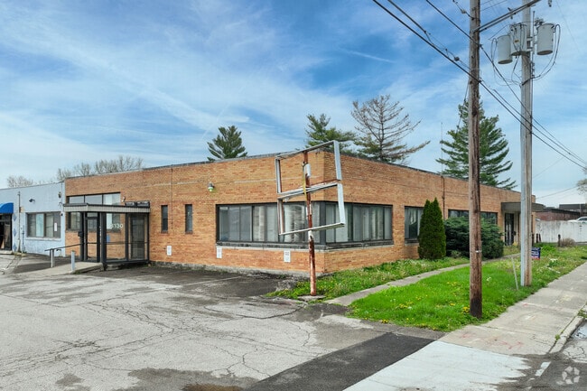
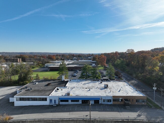
This Property Is For Sale
NEARBY LISTINGS FOR SALE OR LEASE
Property Detail
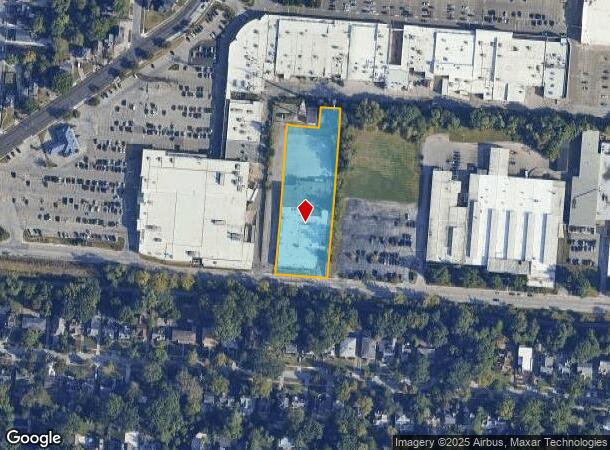
3130 Wasson Rd
Cincinnati, OH-KY-IN
Catherine Hanfords Sub
039-0A03-0009
3130 WASSON RD 158 X 516.32 IR PT LOT 1 CATHERINE HANFORDS SUB & ILLWAGO ST VAC
Industrialgeneral
Hamilton
X
Ohio
39061C0243F
1
2024
1.75 AC
2024
Central/Midtown
005301
Cincinnati/Dayton
37,628 SF
DEMOGRAPHICS near 3130 Wasson Rd
1 Mile
3 Mile
5 Mile
2024 Total Population
17,397
101,293
254,428
2029 Population
16,992
100,475
253,815
Pop Growth 2024-2029
(2.33%)
(0.81%)
(0.24%)
Average Age
37
38
39
2024 Total Households
9,019
46,720
113,514
HH Growth 2024-2029
(2.51%)
(1.02%)
(0.35%)
Median Household Inc
$103,529
$71,205
$65,485
Avg Household Size
1.90
2.00
2.10
2024 Avg HH Vehicles
2.00
2.00
2.00
Median Home Value
$394,364
$270,488
$251,448
Median Year Built
1947
1948
1949
Nearby Places
- Restaurants
- Banks
- Shops
- Fitness
- Groceries
PUBLIC TRANSPORTATION
COMMUTER RAIL
DRIVE
WALK
Distance
17 min
9.0 mi
AIRPORT
Cincinnati/Northern Kentucky International
DRIVE
WALK
Distance
Cincinnati/Northern Kentucky International
38 min
21.1 mi
Nearby Properties
Address
Land Use
TOTAL SIZE
Lot Size
Zoning
Address
Land Use
TOTAL SIZE
Lot Size
Zoning
62.10 AC
Address
Land Use
TOTAL SIZE
Lot Size
Zoning
13.80 AC
Address
Land Use
TOTAL SIZE
Lot Size
Zoning
21.34 AC
Address
Land Use
TOTAL SIZE
Lot Size
Zoning
27.30 AC
M2
Address
Land Use
TOTAL SIZE
Lot Size
Zoning
11.68 AC
Address
Land Use
TOTAL SIZE
Lot Size
Zoning
26,453 SF
19.91 AC
M2
Address
Land Use
TOTAL SIZE
Lot Size
Zoning
148,748 SF
24.90 AC
CGA
Address
Land Use
TOTAL SIZE
Lot Size
Zoning
3.17 AC
R2PUD
Address
Land Use
TOTAL SIZE
Lot Size
Zoning
9.16 AC
Address
Land Use
TOTAL SIZE
Lot Size
Zoning
Address
Land Use
TOTAL SIZE
Lot Size
Zoning
10.76 AC
Address
Land Use
TOTAL SIZE
Lot Size
Zoning
5.07 AC
Address
Land Use
TOTAL SIZE
Lot Size
Zoning
Address
Land Use
TOTAL SIZE
Lot Size
Zoning
6.93 AC
MG
Address
Land Use
TOTAL SIZE
Lot Size
Zoning
0.26 AC
RM12
Address
Land Use
TOTAL SIZE
Lot Size
Zoning
8.05 AC
Address
Land Use
TOTAL SIZE
Lot Size
Zoning
Address
Land Use
TOTAL SIZE
Lot Size
Zoning
2,916 SF
27.68 AC
Address
Land Use
TOTAL SIZE
Lot Size
Zoning
3.34 AC
Address
Land Use
TOTAL SIZE
Lot Size
Zoning
83,122 SF
1.99 AC
Address
Land Use
TOTAL SIZE
Lot Size
Zoning
1,187 SF
31.75 AC
ML
Address
Land Use
TOTAL SIZE
Lot Size
Zoning
6.91 AC
Address
Land Use
TOTAL SIZE
Lot Size
Zoning
3,864 SF
5.30 AC
PD
Address
Land Use
TOTAL SIZE
Lot Size
Zoning
19.17 AC
ML
Address
Land Use
TOTAL SIZE
Lot Size
Zoning
4,706 SF
18.29 AC
RM20
Address
Land Use
TOTAL SIZE
Lot Size
Zoning
7.06 AC
Address
Land Use
TOTAL SIZE
Lot Size
Zoning
1,152 SF
24.78 AC
B
Address
Land Use
TOTAL SIZE
Lot Size
Zoning
2.17 AC
O
Address
Land Use
TOTAL SIZE
Lot Size
Zoning
18.51 AC
RM20
Address
Land Use
TOTAL SIZE
Lot Size
Zoning
15.86 AC
The World's #1 Commercial Real Estate Marketplace
Connect with us
© 2025 CoStar Group
The information above has been obtained from sources believed reliable. While we do not doubt its accuracy we have not verified it and make no guarantee, warranty or representation about it. It is your responsibility to independently confirm its accuracy and completeness. Any projections, opinions, assumptions, or estimates used are for example only and do not represent the current or future performance of the property. The value of this transaction to you depends on tax and other factors which should be evaluated by your tax, financial, and legal advisors. You and your advisors should conduct a careful, independent investigation of the property to determine to your satisfaction the suitability of the property for your needs.