Property Record
3131 Premier Dr, Irving, TX 75063
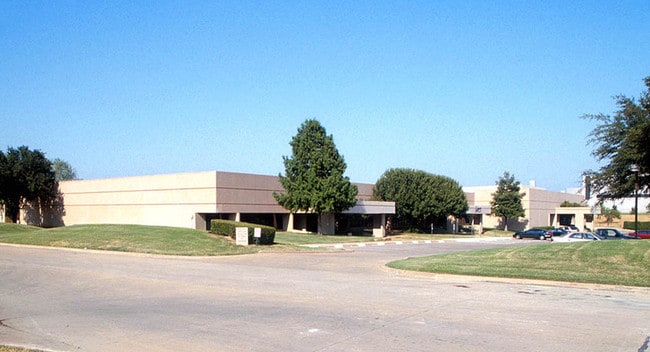

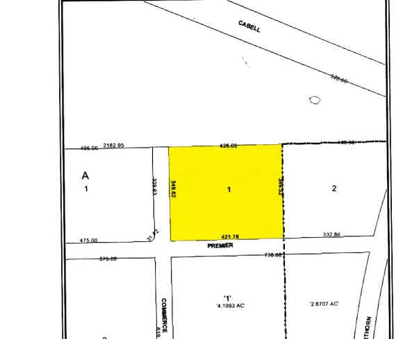
Property Detail
3131 Premier Dr
32668000000010000
LAS COLINAS BUS PK 14TH INST LT 1 ACS 3.4018 INT200600105470 DD03212006 CO-DC 6680000000100 1CI66800000
Commercialnec
DALLAS
Z128
Texas
B and X Area of moderate flood hazard, usually the area between the limits of the 100-year and 500-year floods.
1
2024
3.40 AC
2025
E DFW Air/Las Colinas
014159
Dallas/Ft Worth
50,568 SF
Dallas-Fort Worth-Arlington, TX
NEARBY LISTINGS FOR SALE OR LEASE
DEMOGRAPHICS near 3131 Premier Dr
1 mile
3 mile
5 mile
2025 Total Population
6,934
83,703
207,113
2030 Population
7,182
86,863
213,870
Pop Growth 2025-2030
+ 3.58%
+ 3.78%
+ 3.26%
Average Age
32
34
35
2025 Total Households
2,394
33,774
83,202
HH Growth 2025-2030
+ 3.09%
+ 2.79%
+ 3.05%
Median Household Inc
$154,048
$101,615
$96,045
Avg Household Size
2.90
2.50
2.40
2025 Avg HH Vehicles
2.00
2.00
2.00
Median Home Value
$717,403
$591,312
$447,475
Median Year Built
1999
1994
1991
Nearby Places
Map Layers
Map Styles
 Street
 Aerial
Transit
 Traffic
 Biking
Places
Listings with unknown addresses are not visible on the map
- Restaurants
- Banks
- Shops
- Fitness
- Groceries
PUBLIC TRANSPORTATION
COMMUTER RAIL
West Irving Station (TRINITY RAILWAY - Dallas Area Rapid Transit (DART))
Drive
Walk
Distance
West Irving Station (TRINITY RAILWAY - Dallas Area Rapid Transit (DART))
12 min
7.0 mi
East Tex Yard Limit (TRINITY RAILWAY - Dallas Area Rapid Transit (DART))
Drive
Walk
Distance
East Tex Yard Limit (TRINITY RAILWAY - Dallas Area Rapid Transit (DART))
13 min
8.4 mi
AIRPORT
Dallas-Fort Worth International
Drive
Walk
Distance
Dallas-Fort Worth International
12 min
7.4 mi
Dallas Love Field
Drive
Walk
Distance
Dallas Love Field
21 min
12.8 mi
Freight Ports
Port of Shreveport
Drive
Walk
Distance
Port of Shreveport
230 min
212.7 mi
Nearby Properties
Address
Land Use
TOTAL SIZE
Lot Size
Zoning
Address
Land Use
TOTAL SIZE
Lot Size
Zoning
2,496,382 SF
256.13 AC
Z392
Address
Land Use
TOTAL SIZE
Lot Size
Zoning
962,320 SF
23.81 AC
Z198
Address
Land Use
TOTAL SIZE
Lot Size
Zoning
1,520,000 SF
34.76 AC
Z243
Address
Land Use
TOTAL SIZE
Lot Size
Zoning
565,728 SF
21.07 AC
Address
Land Use
TOTAL SIZE
Lot Size
Zoning
346,000 SF
15.52 AC
Z198
Address
Land Use
TOTAL SIZE
Lot Size
Zoning
379,000 SF
9.81 AC
Z243
Address
Land Use
TOTAL SIZE
Lot Size
Zoning
674,817 SF
15.35 AC
Z84
Address
Land Use
TOTAL SIZE
Lot Size
Zoning
689,004 SF
25.23 AC
Z243
Address
Land Use
TOTAL SIZE
Lot Size
Zoning
471,524 SF
20.34 AC
Z84
Address
Land Use
TOTAL SIZE
Lot Size
Zoning
1,144,971 SF
19.43 AC
Z84
Address
Land Use
TOTAL SIZE
Lot Size
Zoning
729,870 SF
24.42 AC
Z393
Address
Land Use
TOTAL SIZE
Lot Size
Zoning
550,411 SF
19.39 AC
Z243
Address
Land Use
TOTAL SIZE
Lot Size
Zoning
464,996 SF
18.43 AC
SP2
Address
Land Use
TOTAL SIZE
Lot Size
Zoning
371,837 SF
54.36 AC
Z86
Address
Land Use
TOTAL SIZE
Lot Size
Zoning
808,352 SF
7.87 AC
Address
Land Use
TOTAL SIZE
Lot Size
Zoning
648,613 SF
25.51 AC
Z392
Address
Land Use
TOTAL SIZE
Lot Size
Zoning
347,008 SF
9.54 AC
Z57
Address
Land Use
TOTAL SIZE
Lot Size
Zoning
1,219,380 SF
16.01 AC
Z243
Address
Land Use
TOTAL SIZE
Lot Size
Zoning
1,076,400 SF
48.83 AC
Z01
Address
Land Use
TOTAL SIZE
Lot Size
Zoning
457,322 SF
22.98 AC
Z243
Address
Land Use
TOTAL SIZE
Lot Size
Zoning
543,965 SF
8.02 AC
Z323
Address
Land Use
TOTAL SIZE
Lot Size
Zoning
717,650 SF
28.32 AC
Z243
Address
Land Use
TOTAL SIZE
Lot Size
Zoning
588,626 SF
6.55 AC
Z84
Address
Land Use
TOTAL SIZE
Lot Size
Zoning
204,167 SF
68 AC
Z239
Address
Land Use
TOTAL SIZE
Lot Size
Zoning
414,646 SF
18.37 AC
Z49
Address
Land Use
TOTAL SIZE
Lot Size
Zoning
505,823 SF
29.64 AC
Z113
Address
Land Use
TOTAL SIZE
Lot Size
Zoning
405,543 SF
9.53 AC
Z243
Address
Land Use
TOTAL SIZE
Lot Size
Zoning
426,365 SF
14.77 AC
Z239
Address
Land Use
TOTAL SIZE
Lot Size
Zoning
634,939 SF
52.29 AC
Z84
Address
Land Use
TOTAL SIZE
Lot Size
Zoning
779,551 SF
6.50 AC
The World's #1 Commercial Real Estate Marketplace
Connect with us
© 2026 CoStar Group
The information above has been obtained from sources believed reliable. While we do not doubt its accuracy we have not verified it and make no guarantee, warranty or representation about it. It is your responsibility to independently confirm its accuracy and completeness. Any projections, opinions, assumptions, or estimates used are for example only and do not represent the current or future performance of the property. The value of this transaction to you depends on tax and other factors which should be evaluated by your tax, financial, and legal advisors. You and your advisors should conduct a careful, independent investigation of the property to determine to your satisfaction the suitability of the property for your needs.