Property Record
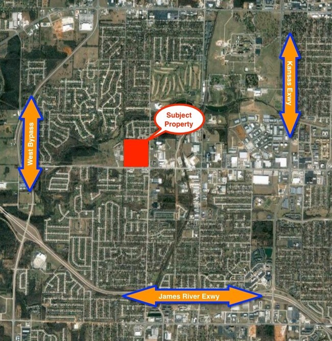
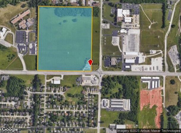
3131 W Battlefield St, Springfield, MO 65807
NEARBY LISTINGS FOR SALE OR LEASE
Property Detail
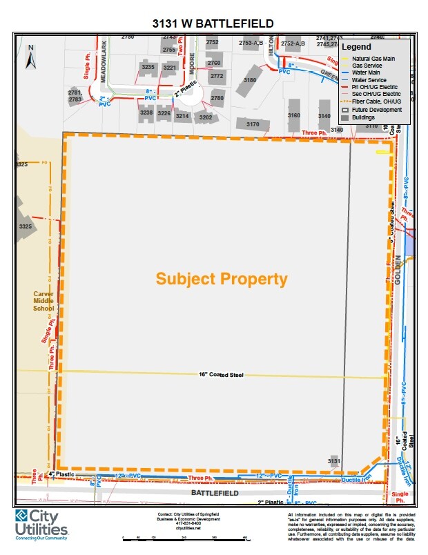
3131 W Battlefield St
18-04-202-006
36.03A M/L SE1/4 NW1/4 (EX E 6A) & (EX RD) 4/28/22 (EX PT DE EDED FOR NEW R/W)
Commercialacreage
Greene
X
Missouri
29077C0337E
36.03 AC
2025
Southwest
2025
Springfield
001401
Springfield, MO
DEMOGRAPHICS near 3131 W Battlefield St
1 Mile
3 Mile
5 Mile
2024 Total Population
8,306
63,345
150,861
2029 Population
8,495
65,696
156,545
Pop Growth 2024-2029
+ 2.28%
+ 3.71%
+ 3.77%
Average Age
40
39
38
2024 Total Households
3,629
27,946
66,512
HH Growth 2024-2029
+ 2.37%
+ 4.00%
+ 4.04%
Median Household Inc
$57,785
$51,627
$49,466
Avg Household Size
2.30
2.20
2.10
2024 Avg HH Vehicles
2.00
2.00
2.00
Median Home Value
$182,836
$168,777
$171,014
Median Year Built
1992
1992
1985
Nearby Places
Map Layers
Map Styles
 Street
 Aerial
- Restaurants
- Banks
- Shops
- Fitness
- Groceries
PUBLIC TRANSPORTATION
AIRPORT
Springfield-Branson Ntl
DRIVE
WALK
Distance
Springfield-Branson Ntl
23 min
9.9 mi
Freight Ports
Tulsa Port of Inola
DRIVE
WALK
Distance
Tulsa Port of Inola
189 min
169.6 mi
SALE & LEASE HISTORY
LISTING DATE
SALE/LEASE

Jun 21, 2017
For Sale
Nearby Properties
Address
Land Use
TOTAL SIZE
Lot Size
Zoning
Address
Land Use
TOTAL SIZE
Lot Size
Zoning
18.52 AC
INC
Address
Land Use
TOTAL SIZE
Lot Size
Zoning
12.35 AC
INC
Address
Land Use
TOTAL SIZE
Lot Size
Zoning
22.64 AC
INC
Address
Land Use
TOTAL SIZE
Lot Size
Zoning
Address
Land Use
TOTAL SIZE
Lot Size
Zoning
312,092 SF
38 AC
INC
Address
Land Use
TOTAL SIZE
Lot Size
Zoning
614,588 SF
57.27 AC
INC
Address
Land Use
TOTAL SIZE
Lot Size
Zoning
26.03 AC
INC
Address
Land Use
TOTAL SIZE
Lot Size
Zoning
129,652 SF
16.40 AC
INC
Address
Land Use
TOTAL SIZE
Lot Size
Zoning
334,594 SF
17.75 AC
INC
Address
Land Use
TOTAL SIZE
Lot Size
Zoning
253,781 SF
9.65 AC
INC
Address
Land Use
TOTAL SIZE
Lot Size
Zoning
9.82 AC
INC
Address
Land Use
TOTAL SIZE
Lot Size
Zoning
140,147 SF
17.64 AC
INC
Address
Land Use
TOTAL SIZE
Lot Size
Zoning
159,007 SF
16.05 AC
INC
Address
Land Use
TOTAL SIZE
Lot Size
Zoning
30,400 SF
9.05 AC
INC
Address
Land Use
TOTAL SIZE
Lot Size
Zoning
16.41 AC
INC
Address
Land Use
TOTAL SIZE
Lot Size
Zoning
27.78 AC
INC
Address
Land Use
TOTAL SIZE
Lot Size
Zoning
6.24 AC
INC
Address
Land Use
TOTAL SIZE
Lot Size
Zoning
65,208 SF
12.40 AC
INC
Address
Land Use
TOTAL SIZE
Lot Size
Zoning
12.81 AC
INC
Address
Land Use
TOTAL SIZE
Lot Size
Zoning
172,976 SF
5.99 AC
INC
Address
Land Use
TOTAL SIZE
Lot Size
Zoning
157,773 SF
18.55 AC
INC
Address
Land Use
TOTAL SIZE
Lot Size
Zoning
237,818 SF
20.86 AC
INC
Address
Land Use
TOTAL SIZE
Lot Size
Zoning
8.82 AC
INC
Address
Land Use
TOTAL SIZE
Lot Size
Zoning
6.53 AC
INC.
Address
Land Use
TOTAL SIZE
Lot Size
Zoning
16.39 AC
INC
Address
Land Use
TOTAL SIZE
Lot Size
Zoning
54,350 SF
9.39 AC
INC
Address
Land Use
TOTAL SIZE
Lot Size
Zoning
8.26 AC
INC
Address
Land Use
TOTAL SIZE
Lot Size
Zoning
Address
Land Use
TOTAL SIZE
Lot Size
Zoning
3.95 AC
INC
Address
Land Use
TOTAL SIZE
Lot Size
Zoning
153,672 SF
5.17 AC
INC
The World's #1 Commercial Real Estate Marketplace
Connect with us
© 2026 CoStar Group
The information above has been obtained from sources believed reliable. While we do not doubt its accuracy we have not verified it and make no guarantee, warranty or representation about it. It is your responsibility to independently confirm its accuracy and completeness. Any projections, opinions, assumptions, or estimates used are for example only and do not represent the current or future performance of the property. The value of this transaction to you depends on tax and other factors which should be evaluated by your tax, financial, and legal advisors. You and your advisors should conduct a careful, independent investigation of the property to determine to your satisfaction the suitability of the property for your needs.