Property Record
3132 Newport Rd, Newport, MI 48166

NEARBY LISTINGS FOR SALE OR LEASE
Property Detail
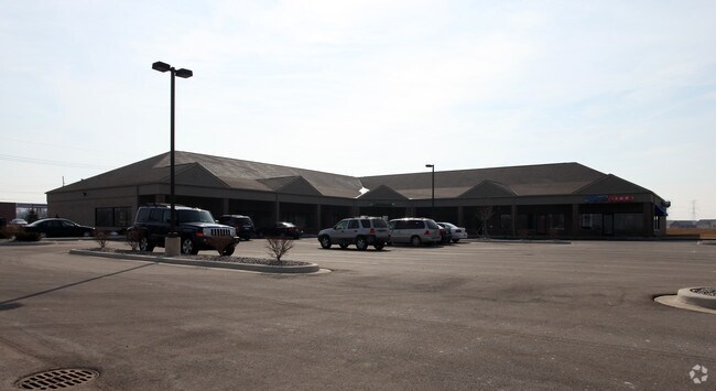
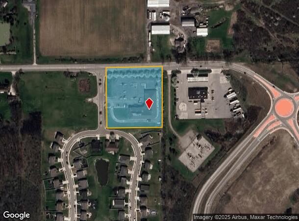
3132 Newport Rd
03-001-110-20
A PARCEL OF LAND IN THE NW 1/4 OF SEC 1, T6S R9E, COM AT THE NW COR OF SEC 1; TH S 89 DEG 52' 48" E 529.81 FT TO POB; TH S 89
Communitycenter
Monroe
X
Michigan
26115C0114E
2.71 AC
2024
Monroe County
2025
Detroit
830200
Monroe, MI
16,239 SF
DEMOGRAPHICS near 3132 Newport Rd
1 Mile
3 Mile
5 Mile
2024 Total Population
2,633
11,602
26,151
2029 Population
2,709
11,854
26,706
Pop Growth 2024-2029
+ 2.89%
+ 2.17%
+ 2.12%
Average Age
36
38
41
2024 Total Households
961
4,330
10,208
HH Growth 2024-2029
+ 2.81%
+ 2.17%
+ 2.11%
Median Household Inc
$71,999
$65,180
$69,826
Avg Household Size
2.70
2.60
2.50
2024 Avg HH Vehicles
2.00
2.00
2.00
Median Home Value
$183,823
$171,693
$212,353
Median Year Built
2001
1997
1989
Nearby Places
- Restaurants
- Banks
- Shops
- Fitness
- Groceries
PUBLIC TRANSPORTATION
AIRPORT
Detroit Metro Wayne County
DRIVE
WALK
Distance
Detroit Metro Wayne County
28 min
19.9 mi
Windsor International
DRIVE
WALK
Distance
Windsor International
56 min
38.5 mi
Freight Ports
DRIVE
WALK
Distance
42 min
31.7 mi
SALE & LEASE HISTORY
LISTING DATE
SALE/LEASE

Sep 25, 2016
For Lease
Oct 21, 2020
For Lease
Nearby Properties
Address
Land Use
TOTAL SIZE
Lot Size
Zoning
Address
Land Use
TOTAL SIZE
Lot Size
Zoning
Address
Land Use
TOTAL SIZE
Lot Size
Zoning
453,206 SF
156.60 AC
AG
Address
Land Use
TOTAL SIZE
Lot Size
Zoning
Address
Land Use
TOTAL SIZE
Lot Size
Zoning
720,420 SF
71.34 AC
LM-LIGHT M
Address
Land Use
TOTAL SIZE
Lot Size
Zoning
5,216 SF
81.10 AC
MHP
Address
Land Use
TOTAL SIZE
Lot Size
Zoning
29.81 AC
MHP
Address
Land Use
TOTAL SIZE
Lot Size
Zoning
41,920 SF
48.72 AC
Address
Land Use
TOTAL SIZE
Lot Size
Zoning
2,100 SF
36.48 AC
MHP
Address
Land Use
TOTAL SIZE
Lot Size
Zoning
100,407 SF
16.34 AC
Address
Land Use
TOTAL SIZE
Lot Size
Zoning
4,419 SF
64.34 AC
MHP
Address
Land Use
TOTAL SIZE
Lot Size
Zoning
28.87 AC
MHP
Address
Land Use
TOTAL SIZE
Lot Size
Zoning
100,918 SF
14.41 AC
Address
Land Use
TOTAL SIZE
Lot Size
Zoning
3,272 SF
121.75 AC
MHP
Address
Land Use
TOTAL SIZE
Lot Size
Zoning
26.52 AC
MHP
Address
Land Use
TOTAL SIZE
Lot Size
Zoning
2,472 SF
46.65 AC
Address
Land Use
TOTAL SIZE
Lot Size
Zoning
37,665 SF
9.13 AC
Address
Land Use
TOTAL SIZE
Lot Size
Zoning
36,604 SF
3.96 AC
Address
Land Use
TOTAL SIZE
Lot Size
Zoning
5,712 SF
0.84 AC
Address
Land Use
TOTAL SIZE
Lot Size
Zoning
37,447 SF
4.71 AC
Address
Land Use
TOTAL SIZE
Lot Size
Zoning
34.40 AC
MHP
Address
Land Use
TOTAL SIZE
Lot Size
Zoning
14,118 SF
37.23 AC
Address
Land Use
TOTAL SIZE
Lot Size
Zoning
8,048 SF
148.21 AC
Address
Land Use
TOTAL SIZE
Lot Size
Zoning
3,136 SF
3.92 AC
Address
Land Use
TOTAL SIZE
Lot Size
Zoning
13,730 SF
2.43 AC
Address
Land Use
TOTAL SIZE
Lot Size
Zoning
9,146 SF
1.86 AC
Address
Land Use
TOTAL SIZE
Lot Size
Zoning
3,794 SF
56.59 AC
A-AGRICULT
Address
Land Use
TOTAL SIZE
Lot Size
Zoning
13,500 SF
2.34 AC
Address
Land Use
TOTAL SIZE
Lot Size
Zoning
4,950 SF
1.65 AC
Address
Land Use
TOTAL SIZE
Lot Size
Zoning
28,800 SF
13.60 AC
The World's #1 Commercial Real Estate Marketplace
Connect with us
© 2025 CoStar Group
The information above has been obtained from sources believed reliable. While we do not doubt its accuracy we have not verified it and make no guarantee, warranty or representation about it. It is your responsibility to independently confirm its accuracy and completeness. Any projections, opinions, assumptions, or estimates used are for example only and do not represent the current or future performance of the property. The value of this transaction to you depends on tax and other factors which should be evaluated by your tax, financial, and legal advisors. You and your advisors should conduct a careful, independent investigation of the property to determine to your satisfaction the suitability of the property for your needs.