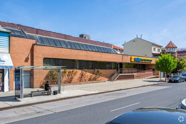
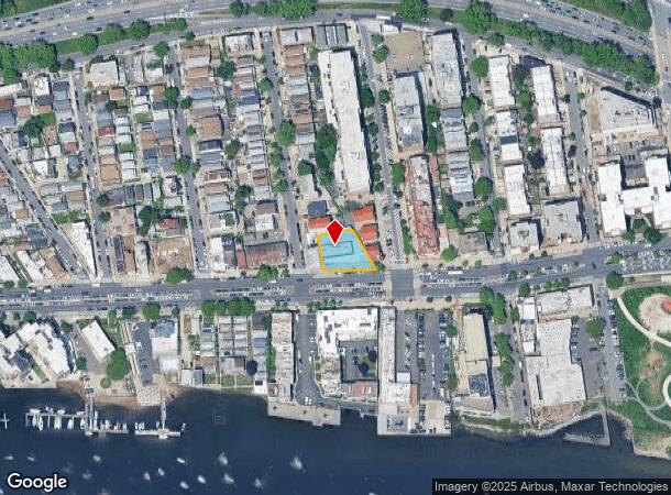
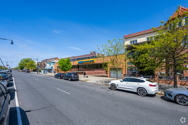
Property Record
3133 Emmons Ave, Brooklyn, NY 11235
NEARBY LISTINGS FOR SALE OR LEASE
Property Detail
3133 Emmons Ave
08804-0075
ADDL BLK-LOT: 8804-80;ID2008123000122001
Funeralhome
Kings
X
New York
3604970358F
75
2024
0.30 AC
2025
South Brooklyn
060800
Long Island (New York)
12,956 SF
New York-Jersey City-White Plains, NY-NJ
DEMOGRAPHICS near 3133 Emmons Ave
1 Mile
3 Mile
5 Mile
2024 Total Population
43,147
402,595
1,074,324
2029 Population
40,005
376,471
998,076
Pop Growth 2024-2029
(7.28%)
(6.49%)
(7.10%)
Average Age
44
42
41
2024 Total Households
16,923
146,647
370,513
HH Growth 2024-2029
(7.66%)
(6.83%)
(7.43%)
Median Household Inc
$69,439
$66,336
$64,763
Avg Household Size
2.40
2.60
2.80
2024 Avg HH Vehicles
1.00
1.00
1.00
Median Home Value
$653,539
$738,622
$761,741
Median Year Built
1951
1950
1948
Nearby Places
Map Layers
Map Styles
 Street
 Aerial
- Restaurants
- Banks
- Shops
- Fitness
- Groceries
PUBLIC TRANSPORTATION
COMMUTER RAIL
East New York Station (Far Rockaway Branch - Long Island Rail Road, Long Beach Branch - Long Island Rail Road, West Hempstead Branch - Long Island Rail Road)
DRIVE
WALK
Distance
East New York Station (Far Rockaway Branch - Long Island Rail Road, Long Beach Branch - Long Island Rail Road, West Hempstead Branch - Long Island Rail Road)
15 min
7.6 mi
Nostrand Avenue Station (Far Rockaway Branch - Long Island Rail Road, Hempstead Branch - Long Island Rail Road, Long Beach Branch - Long Island Rail Road, West Hempstead Branch - Long Island Rail Road)
DRIVE
WALK
Distance
Nostrand Avenue Station (Far Rockaway Branch - Long Island Rail Road, Hempstead Branch - Long Island Rail Road, Long Beach Branch - Long Island Rail Road, West Hempstead Branch - Long Island Rail Road)
20 min
8.4 mi
AIRPORT
John F Kennedy International
DRIVE
WALK
Distance
John F Kennedy International
20 min
13.3 mi
LaGuardia
DRIVE
WALK
Distance
LaGuardia
31 min
20.1 mi
Newark Liberty International
DRIVE
WALK
Distance
Newark Liberty International
40 min
25.3 mi
Freight Ports
NY - Red Hook Container Terminal
DRIVE
WALK
Distance
NY - Red Hook Container Terminal
18 min
9.3 mi
Nearby Properties
Address
Land Use
TOTAL SIZE
Lot Size
Zoning
Address
Land Use
TOTAL SIZE
Lot Size
Zoning
100 SF
1,207.35 AC
M1-1
Address
Land Use
TOTAL SIZE
Lot Size
Zoning
1,281,577 SF
20.78 AC
M3-1
Address
Land Use
TOTAL SIZE
Lot Size
Zoning
1,078,317 SF
10.45 AC
R4
Address
Land Use
TOTAL SIZE
Lot Size
Zoning
10,250 SF
773.50 AC
PARK
Address
Land Use
TOTAL SIZE
Lot Size
Zoning
54.78 AC
PARK
Address
Land Use
TOTAL SIZE
Lot Size
Zoning
353,600 SF
55.79 AC
R3-1
Address
Land Use
TOTAL SIZE
Lot Size
Zoning
2,000 SF
253.68 AC
R4
Address
Land Use
TOTAL SIZE
Lot Size
Zoning
12,252,000 SF
190 AC
PARK
Address
Land Use
TOTAL SIZE
Lot Size
Zoning
275,163 SF
9.69 AC
R3-1
Address
Land Use
TOTAL SIZE
Lot Size
Zoning
846,056 SF
20.71 AC
R5
Address
Land Use
TOTAL SIZE
Lot Size
Zoning
59,063 SF
21.56 AC
PARK
Address
Land Use
TOTAL SIZE
Lot Size
Zoning
209,346 SF
18.29 AC
PARK
Address
Land Use
TOTAL SIZE
Lot Size
Zoning
356,000 SF
8.19 AC
R5
Address
Land Use
TOTAL SIZE
Lot Size
Zoning
351,762 SF
1.65 AC
R7A
Address
Land Use
TOTAL SIZE
Lot Size
Zoning
208,015 SF
1.52 AC
R7X
Address
Land Use
TOTAL SIZE
Lot Size
Zoning
221,704 SF
0.83 AC
R5B
Address
Land Use
TOTAL SIZE
Lot Size
Zoning
470,000 SF
3.40 AC
R6
Address
Land Use
TOTAL SIZE
Lot Size
Zoning
105,328 SF
0.11 AC
M1-6
Address
Land Use
TOTAL SIZE
Lot Size
Zoning
521,976 SF
13.59 AC
R5
Address
Land Use
TOTAL SIZE
Lot Size
Zoning
2,000 SF
73.29 AC
PARK
Address
Land Use
TOTAL SIZE
Lot Size
Zoning
60,288 SF
0.76 AC
R5
Address
Land Use
TOTAL SIZE
Lot Size
Zoning
305,046 SF
8.76 AC
R6
Address
Land Use
TOTAL SIZE
Lot Size
Zoning
211,552 SF
7.39 AC
R3-2
Address
Land Use
TOTAL SIZE
Lot Size
Zoning
411,500 SF
3.48 AC
R5B
Address
Land Use
TOTAL SIZE
Lot Size
Zoning
470,000 SF
3.30 AC
R6
Address
Land Use
TOTAL SIZE
Lot Size
Zoning
10,825 SF
5.90 AC
M3-1
Address
Land Use
TOTAL SIZE
Lot Size
Zoning
335,475 SF
7.23 AC
R5
Address
Land Use
TOTAL SIZE
Lot Size
Zoning
547,448 SF
12.50 AC
R5
Address
Land Use
TOTAL SIZE
Lot Size
Zoning
20,000 SF
172.95 AC
PARK
Address
Land Use
TOTAL SIZE
Lot Size
Zoning
141,830 SF
0.22 AC
C64X
The World's #1 Commercial Real Estate Marketplace
Connect with us
© 2025 CoStar Group
The information above has been obtained from sources believed reliable. While we do not doubt its accuracy we have not verified it and make no guarantee, warranty or representation about it. It is your responsibility to independently confirm its accuracy and completeness. Any projections, opinions, assumptions, or estimates used are for example only and do not represent the current or future performance of the property. The value of this transaction to you depends on tax and other factors which should be evaluated by your tax, financial, and legal advisors. You and your advisors should conduct a careful, independent investigation of the property to determine to your satisfaction the suitability of the property for your needs.