Property Record
31330 Schoolcraft Rd, Livonia, MI 48150
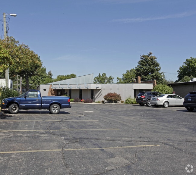


This Property Is For Sale
NEARBY LISTINGS FOR SALE OR LEASE
Property Detail
31330 Schoolcraft Rd
Detroit-Warren-Dearborn, MI
Bai Lynn Park
46-091-03-0014-005
23NOLAB2C BAI LYNN PARK T1S R9E L84 P9 WCR W 70 FT OF THE E 150 FT OF OUT- LOT A
Medicalbuilding
Wayne
X
Michigan
26163C0063E
a
2025
0.48 AC
2025
Southern I-275 Corridor
558100
Detroit
6,702 SF
DEMOGRAPHICS near 31330 Schoolcraft Rd
1 Mile
3 Mile
5 Mile
2024 Total Population
6,065
75,458
247,984
2029 Population
5,777
72,236
238,404
Pop Growth 2024-2029
(4.75%)
(4.27%)
(3.86%)
Average Age
43
43
42
2024 Total Households
2,443
30,714
103,813
HH Growth 2024-2029
(4.79%)
(4.29%)
(3.87%)
Median Household Inc
$93,992
$85,534
$68,825
Avg Household Size
2.40
2.40
2.30
2024 Avg HH Vehicles
2.00
2.00
2.00
Median Home Value
$238,870
$200,816
$184,619
Median Year Built
1960
1958
1960
Nearby Places
Map Layers
Map Styles
 Street
 Aerial
- Restaurants
- Banks
- Shops
- Fitness
- Groceries
PUBLIC TRANSPORTATION
AIRPORT
Detroit Metro Wayne County
DRIVE
WALK
Distance
Detroit Metro Wayne County
28 min
13.9 mi
Windsor International
DRIVE
WALK
Distance
Windsor International
45 min
28.3 mi
Freight Ports
DRIVE
WALK
Distance
78 min
64.4 mi
Nearby Properties
Address
Land Use
TOTAL SIZE
Lot Size
Zoning
Address
Land Use
TOTAL SIZE
Lot Size
Zoning
3,733,882 SF
183.17 AC
M-2
Address
Land Use
TOTAL SIZE
Lot Size
Zoning
1,316,911 SF
72.87 AC
M-1
Address
Land Use
TOTAL SIZE
Lot Size
Zoning
1,071,675 SF
59.61 AC
M-2
Address
Land Use
TOTAL SIZE
Lot Size
Zoning
909,159 SF
55.33 AC
M-2
Address
Land Use
TOTAL SIZE
Lot Size
Zoning
480,910 SF
26.32 AC
Address
Land Use
TOTAL SIZE
Lot Size
Zoning
199,485 SF
10.31 AC
R-9
Address
Land Use
TOTAL SIZE
Lot Size
Zoning
1,156,275 SF
75.88 AC
M-2
Address
Land Use
TOTAL SIZE
Lot Size
Zoning
1,013,885 SF
36.48 AC
M-1
Address
Land Use
TOTAL SIZE
Lot Size
Zoning
Address
Land Use
TOTAL SIZE
Lot Size
Zoning
176,396 SF
11.76 AC
Address
Land Use
TOTAL SIZE
Lot Size
Zoning
206,130 SF
14.12 AC
Address
Land Use
TOTAL SIZE
Lot Size
Zoning
399,770 SF
34.90 AC
M-2
Address
Land Use
TOTAL SIZE
Lot Size
Zoning
Address
Land Use
TOTAL SIZE
Lot Size
Zoning
121,420 SF
16.01 AC
C-2
Address
Land Use
TOTAL SIZE
Lot Size
Zoning
137,490 SF
12.16 AC
C-2
Address
Land Use
TOTAL SIZE
Lot Size
Zoning
1,529,287 SF
76.96 AC
M-1
Address
Land Use
TOTAL SIZE
Lot Size
Zoning
164,964 SF
14.96 AC
R-7
Address
Land Use
TOTAL SIZE
Lot Size
Zoning
205,368 SF
20.22 AC
C-2
Address
Land Use
TOTAL SIZE
Lot Size
Zoning
216,268 SF
23.58 AC
C-2
Address
Land Use
TOTAL SIZE
Lot Size
Zoning
282,088 SF
14.34 AC
M-2
Address
Land Use
TOTAL SIZE
Lot Size
Zoning
225,520 SF
9.93 AC
PO
Address
Land Use
TOTAL SIZE
Lot Size
Zoning
100,887 SF
5.34 AC
C-4
Address
Land Use
TOTAL SIZE
Lot Size
Zoning
102,089 SF
10.94 AC
C-2
Address
Land Use
TOTAL SIZE
Lot Size
Zoning
151,605 SF
14.66 AC
C-2
Address
Land Use
TOTAL SIZE
Lot Size
Zoning
286,524 SF
16.58 AC
Address
Land Use
TOTAL SIZE
Lot Size
Zoning
244,838 SF
8.93 AC
M-1
Address
Land Use
TOTAL SIZE
Lot Size
Zoning
182,700 SF
20.45 AC
C-2
Address
Land Use
TOTAL SIZE
Lot Size
Zoning
204,798 SF
9.24 AC
M-1
Address
Land Use
TOTAL SIZE
Lot Size
Zoning
57,739 SF
1.71 AC
Address
Land Use
TOTAL SIZE
Lot Size
Zoning
44,782 SF
4.15 AC
The World's #1 Commercial Real Estate Marketplace
Connect with us
© 2026 CoStar Group
The information above has been obtained from sources believed reliable. While we do not doubt its accuracy we have not verified it and make no guarantee, warranty or representation about it. It is your responsibility to independently confirm its accuracy and completeness. Any projections, opinions, assumptions, or estimates used are for example only and do not represent the current or future performance of the property. The value of this transaction to you depends on tax and other factors which should be evaluated by your tax, financial, and legal advisors. You and your advisors should conduct a careful, independent investigation of the property to determine to your satisfaction the suitability of the property for your needs.