Property Record
3137 Cedar Park Rd, Greensboro, NC 27405
NEARBY LISTINGS FOR SALE OR LEASE
-
-
View all Greensboro listings for sale on LoopNet.com
Property Detail
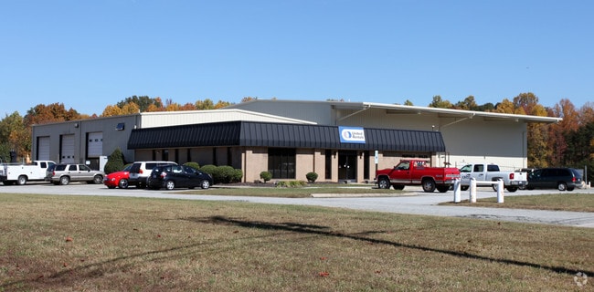
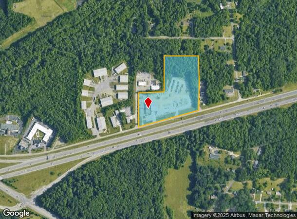
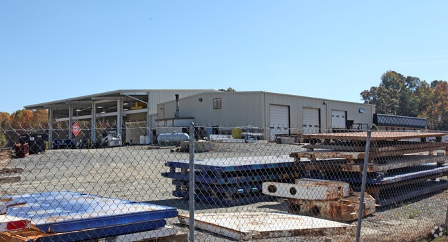
3137 Cedar Park Rd
Greensboro-High Point, NC
P J Coble & T L Coble Prop
0118737
4.06AC 2 PB73-139 &1AC TR ANSCO & ASSOC
Industrialgeneral
Guilford
X
North Carolina
3710788300J
15
2024
11.03 AC
2025
SE Guilford County
012803
Greensboro/Winston-Salem
16,256 SF
DEMOGRAPHICS near 3137 Cedar Park Rd
1 Mile
3 Mile
5 Mile
2024 Total Population
1,449
37,420
112,173
2029 Population
1,433
37,571
112,486
Pop Growth 2024-2029
(1.10%)
+ 0.40%
+ 0.28%
Average Age
39
37
36
2024 Total Households
522
14,032
41,595
HH Growth 2024-2029
(1.15%)
+ 0.48%
+ 0.47%
Median Household Inc
$69,354
$41,238
$43,592
Avg Household Size
2.70
2.50
2.30
2024 Avg HH Vehicles
3.00
2.00
2.00
Median Home Value
$197,958
$137,764
$153,254
Median Year Built
2000
1977
1974
Nearby Places
Map Layers
Map Styles
 Street
 Aerial
- Restaurants
- Banks
- Shops
- Fitness
- Groceries
PUBLIC TRANSPORTATION
COMMUTER RAIL
Greensboro Station (Piedmont - North Carolina by Train (NC Train))
DRIVE
WALK
Distance
Greensboro Station (Piedmont - North Carolina by Train (NC Train))
9 min
4.1 mi
AIRPORT
Piedmont Triad International
DRIVE
WALK
Distance
Piedmont Triad International
27 min
15.3 mi
Freight Ports
Virginia Port Authority - Richmond
DRIVE
WALK
Distance
Virginia Port Authority - Richmond
223 min
194.5 mi
Nearby Properties
Address
Land Use
TOTAL SIZE
Lot Size
Zoning
Address
Land Use
TOTAL SIZE
Lot Size
Zoning
905,672 SF
28.64 AC
PI
Address
Land Use
TOTAL SIZE
Lot Size
Zoning
1,546,815 SF
93.94 AC
CU-LI
Address
Land Use
TOTAL SIZE
Lot Size
Zoning
313,033 SF
71.38 AC
O
Address
Land Use
TOTAL SIZE
Lot Size
Zoning
402,136 SF
31.27 AC
HI
Address
Land Use
TOTAL SIZE
Lot Size
Zoning
364,783 SF
30.12 AC
RM-18
Address
Land Use
TOTAL SIZE
Lot Size
Zoning
418,596 SF
23.53 AC
LI
Address
Land Use
TOTAL SIZE
Lot Size
Zoning
224,444 SF
80.09 AC
PI
Address
Land Use
TOTAL SIZE
Lot Size
Zoning
275,282 SF
43.43 AC
PI
Address
Land Use
TOTAL SIZE
Lot Size
Zoning
505,615 SF
39.50 AC
LI
Address
Land Use
TOTAL SIZE
Lot Size
Zoning
661,843 SF
46.38 AC
PI
Address
Land Use
TOTAL SIZE
Lot Size
Zoning
345,087 SF
15.73 AC
PI
Address
Land Use
TOTAL SIZE
Lot Size
Zoning
267,277 SF
12.97 AC
PI
Address
Land Use
TOTAL SIZE
Lot Size
Zoning
310,758 SF
63.58 AC
PI
Address
Land Use
TOTAL SIZE
Lot Size
Zoning
281,330 SF
21.18 AC
HI
Address
Land Use
TOTAL SIZE
Lot Size
Zoning
344,972 SF
65.45 AC
LI
Address
Land Use
TOTAL SIZE
Lot Size
Zoning
293,760 SF
21.94 AC
LI
Address
Land Use
TOTAL SIZE
Lot Size
Zoning
363,920 SF
34.27 AC
LI
Address
Land Use
TOTAL SIZE
Lot Size
Zoning
419,126 SF
33.68 AC
LI
Address
Land Use
TOTAL SIZE
Lot Size
Zoning
82,450 SF
117.82 AC
R-5
Address
Land Use
TOTAL SIZE
Lot Size
Zoning
240,170 SF
14.01 AC
LI
Address
Land Use
TOTAL SIZE
Lot Size
Zoning
301,592 SF
19.38 AC
LI
Address
Land Use
TOTAL SIZE
Lot Size
Zoning
238,315 SF
19.63 AC
RM-12
Address
Land Use
TOTAL SIZE
Lot Size
Zoning
141,210 SF
4.42 AC
PUD
Address
Land Use
TOTAL SIZE
Lot Size
Zoning
141,729 SF
8.68 AC
O
Address
Land Use
TOTAL SIZE
Lot Size
Zoning
128,500 SF
14.15 AC
LI
Address
Land Use
TOTAL SIZE
Lot Size
Zoning
1,097,293 SF
73.53 AC
HI
Address
Land Use
TOTAL SIZE
Lot Size
Zoning
152,857 SF
11.58 AC
RM-18
Address
Land Use
TOTAL SIZE
Lot Size
Zoning
153,900 SF
14.23 AC
LI
Address
Land Use
TOTAL SIZE
Lot Size
Zoning
262,937 SF
20.40 AC
RM-18
Address
Land Use
TOTAL SIZE
Lot Size
Zoning
102,782 SF
4 AC
PUD
The World's #1 Commercial Real Estate Marketplace
Connect with us
© 2025 CoStar Group
The information above has been obtained from sources believed reliable. While we do not doubt its accuracy we have not verified it and make no guarantee, warranty or representation about it. It is your responsibility to independently confirm its accuracy and completeness. Any projections, opinions, assumptions, or estimates used are for example only and do not represent the current or future performance of the property. The value of this transaction to you depends on tax and other factors which should be evaluated by your tax, financial, and legal advisors. You and your advisors should conduct a careful, independent investigation of the property to determine to your satisfaction the suitability of the property for your needs.