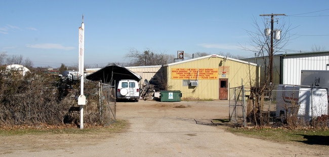
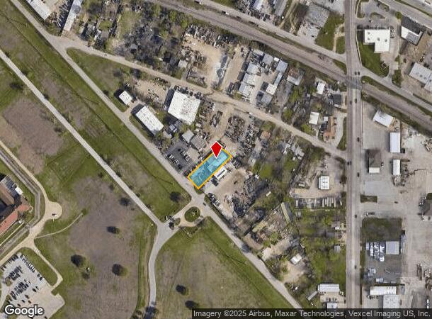
Property Record
3139 Horton Rd, Forest Hill, TX 76119
NEARBY LISTINGS FOR SALE OR LEASE
Property Detail
3139 Horton Rd
Dallas-Fort Worth-Arlington, TX
Trentman City Addition
03172201
TRENTMAN CITY ADDITION BLOCK 18 LOT 26
Commercialnec
Tarrant
X
Texas
48439C0320L
26
2024
0.37 AC
2025
S Cen.Tarrant Cnty
111104
Dallas/Ft Worth
5,320 SF
DEMOGRAPHICS near 3139 Horton Rd
1 Mile
3 Mile
5 Mile
2024 Total Population
10,836
92,073
259,553
2029 Population
11,356
97,265
274,944
Pop Growth 2024-2029
+ 4.80%
+ 5.64%
+ 5.93%
Average Age
34
35
35
2024 Total Households
2,681
27,878
83,353
HH Growth 2024-2029
+ 4.81%
+ 5.72%
+ 6.11%
Median Household Inc
$38,443
$42,306
$49,420
Avg Household Size
3.30
3.10
2.90
2024 Avg HH Vehicles
2.00
2.00
2.00
Median Home Value
$144,056
$129,035
$166,680
Median Year Built
1969
1969
1971
Nearby Places
Map Layers
Map Styles
 Street
 Aerial
- Restaurants
- Banks
- Shops
- Fitness
- Groceries
PUBLIC TRANSPORTATION
COMMUTER RAIL
Texas And Pacific (T&P) (Trinity Railway Express - Dallas Area Rapid Transit (DART))
DRIVE
WALK
Distance
Texas And Pacific (T&P) (Trinity Railway Express - Dallas Area Rapid Transit (DART))
11 min
7.0 mi
DRIVE
WALK
Distance
12 min
7.3 mi
AIRPORT
Dallas-Fort Worth International
DRIVE
WALK
Distance
Dallas-Fort Worth International
41 min
29.6 mi
Dallas Love Field
DRIVE
WALK
Distance
Dallas Love Field
52 min
40.4 mi
Nearby Properties
Address
Land Use
TOTAL SIZE
Lot Size
Zoning
Address
Land Use
TOTAL SIZE
Lot Size
Zoning
661,238 SF
38.80 AC
Address
Land Use
TOTAL SIZE
Lot Size
Zoning
1,623,188 SF
84.13 AC
Address
Land Use
TOTAL SIZE
Lot Size
Zoning
948,833 SF
64.37 AC
Address
Land Use
TOTAL SIZE
Lot Size
Zoning
343,416 SF
101.49 AC
Address
Land Use
TOTAL SIZE
Lot Size
Zoning
1,129,204 SF
74.34 AC
Address
Land Use
TOTAL SIZE
Lot Size
Zoning
593,917 SF
45.85 AC
Address
Land Use
TOTAL SIZE
Lot Size
Zoning
605,489 SF
35.12 AC
Address
Land Use
TOTAL SIZE
Lot Size
Zoning
295,784 SF
8.87 AC
Address
Land Use
TOTAL SIZE
Lot Size
Zoning
266,514 SF
14.06 AC
Address
Land Use
TOTAL SIZE
Lot Size
Zoning
615,054 SF
27.49 AC
Address
Land Use
TOTAL SIZE
Lot Size
Zoning
488,564 SF
29.43 AC
Address
Land Use
TOTAL SIZE
Lot Size
Zoning
585,000 SF
28.75 AC
Address
Land Use
TOTAL SIZE
Lot Size
Zoning
224,000 SF
24.35 AC
Address
Land Use
TOTAL SIZE
Lot Size
Zoning
244,871 SF
11.88 AC
Address
Land Use
TOTAL SIZE
Lot Size
Zoning
487,507 SF
145.80 AC
Address
Land Use
TOTAL SIZE
Lot Size
Zoning
391,540 SF
21.17 AC
Address
Land Use
TOTAL SIZE
Lot Size
Zoning
225,567 SF
13.01 AC
Address
Land Use
TOTAL SIZE
Lot Size
Zoning
765,351 SF
40.31 AC
Address
Land Use
TOTAL SIZE
Lot Size
Zoning
353,875 SF
18.48 AC
Address
Land Use
TOTAL SIZE
Lot Size
Zoning
124,224 SF
20.67 AC
Address
Land Use
TOTAL SIZE
Lot Size
Zoning
112,250 SF
12 AC
Address
Land Use
TOTAL SIZE
Lot Size
Zoning
543,757 SF
34.46 AC
Address
Land Use
TOTAL SIZE
Lot Size
Zoning
254,822 SF
7.71 AC
Address
Land Use
TOTAL SIZE
Lot Size
Zoning
290,660 SF
19.16 AC
Address
Land Use
TOTAL SIZE
Lot Size
Zoning
385,000 SF
26.81 AC
Address
Land Use
TOTAL SIZE
Lot Size
Zoning
310,982 SF
11.41 AC
Address
Land Use
TOTAL SIZE
Lot Size
Zoning
239,360 SF
17.55 AC
Address
Land Use
TOTAL SIZE
Lot Size
Zoning
330,572 SF
18.34 AC
Address
Land Use
TOTAL SIZE
Lot Size
Zoning
259,449 SF
24 AC
Address
Land Use
TOTAL SIZE
Lot Size
Zoning
126,357 SF
16.64 AC
The World's #1 Commercial Real Estate Marketplace
Connect with us
© 2026 CoStar Group
The information above has been obtained from sources believed reliable. While we do not doubt its accuracy we have not verified it and make no guarantee, warranty or representation about it. It is your responsibility to independently confirm its accuracy and completeness. Any projections, opinions, assumptions, or estimates used are for example only and do not represent the current or future performance of the property. The value of this transaction to you depends on tax and other factors which should be evaluated by your tax, financial, and legal advisors. You and your advisors should conduct a careful, independent investigation of the property to determine to your satisfaction the suitability of the property for your needs.