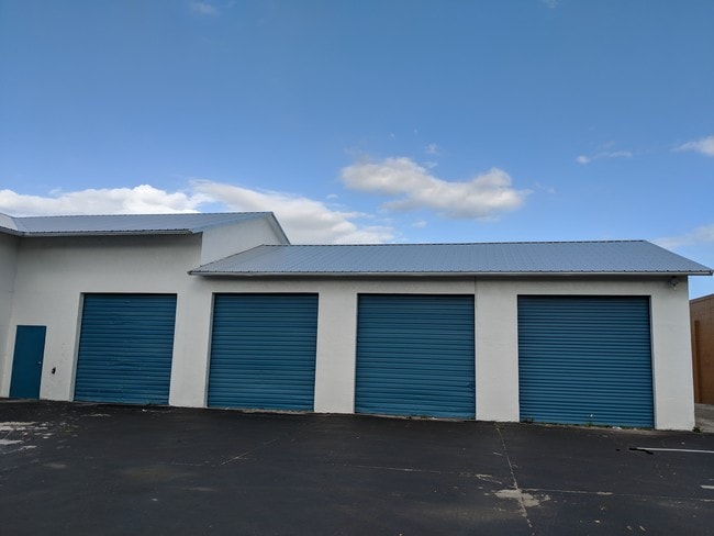
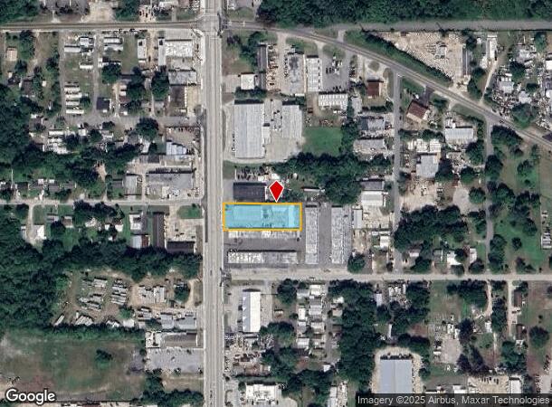
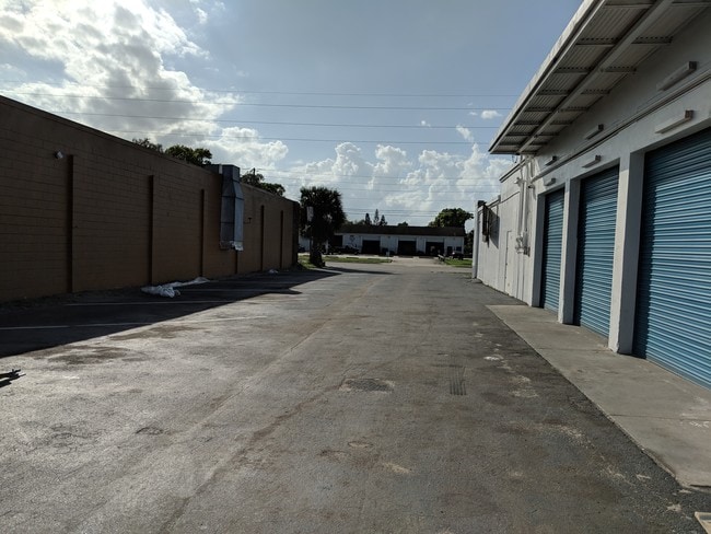
Property Record
316 Clearlake Rd, Cocoa, FL 32922

Current Lease Availabilities
NEARBY LISTINGS FOR SALE OR LEASE
Property Detail
316 Clearlake Rd
24-36-32-00-00269.0-0000.00
S 100 FT OF N 774.60 FT OF E 289.96 FT OF W 329.96 FT OF NW 1/4 AS DES IN ORB 1322 PG 368 & 1346 PG 377
Commercialnec
Brevard
X
Florida
12009C0425G
0.67 AC
2024
Brevard County
2025
Orlando
062600
Palm Bay-Melbourne-Titusville, FL
11,889 SF
DEMOGRAPHICS near 316 Clearlake Rd
1 Mile
3 Mile
5 Mile
2024 Total Population
8,394
40,928
86,268
2029 Population
9,202
44,977
94,305
Pop Growth 2024-2029
+ 9.63%
+ 9.89%
+ 9.32%
Average Age
37
42
44
2024 Total Households
3,120
16,952
36,255
HH Growth 2024-2029
+ 9.39%
+ 9.64%
+ 9.15%
Median Household Inc
$37,500
$47,850
$59,848
Avg Household Size
2.60
2.30
2.30
2024 Avg HH Vehicles
1.00
2.00
2.00
Median Home Value
$112,785
$208,813
$258,869
Median Year Built
1968
1976
1980
Nearby Places
Map Layers
Map Styles
 Street
 Aerial
- Restaurants
- Banks
- Shops
- Fitness
- Groceries
PUBLIC TRANSPORTATION
AIRPORT
Melbourne Orlando International
DRIVE
WALK
Distance
Melbourne Orlando International
38 min
27.3 mi
Freight Ports
Port Canaveral
DRIVE
WALK
Distance
Port Canaveral
19 min
12.0 mi
Nearby Properties
Address
Land Use
TOTAL SIZE
Lot Size
Zoning
Address
Land Use
TOTAL SIZE
Lot Size
Zoning
658,069 SF
268.45 AC
RU17
Address
Land Use
TOTAL SIZE
Lot Size
Zoning
825,903 SF
94.80 AC
RU17
Address
Land Use
TOTAL SIZE
Lot Size
Zoning
411,148 SF
8.13 AC
HC
Address
Land Use
TOTAL SIZE
Lot Size
Zoning
326,407 SF
10 AC
C2
Address
Land Use
TOTAL SIZE
Lot Size
Zoning
497,135 SF
34.13 AC
CW
Address
Land Use
TOTAL SIZE
Lot Size
Zoning
68,677 SF
13.88 AC
RMU
Address
Land Use
TOTAL SIZE
Lot Size
Zoning
307,934 SF
13.66 AC
RU215
Address
Land Use
TOTAL SIZE
Lot Size
Zoning
176,670 SF
13.49 AC
CG
Address
Land Use
TOTAL SIZE
Lot Size
Zoning
264,679 SF
59.90 AC
RU17
Address
Land Use
TOTAL SIZE
Lot Size
Zoning
276,665 SF
38.95 AC
R2
Address
Land Use
TOTAL SIZE
Lot Size
Zoning
176,800 SF
19.23 AC
R3141
Address
Land Use
TOTAL SIZE
Lot Size
Zoning
206,696 SF
11.43 AC
R3
Address
Land Use
TOTAL SIZE
Lot Size
Zoning
8.30 AC
CW
Address
Land Use
TOTAL SIZE
Lot Size
Zoning
211,753 SF
25.16 AC
CG
Address
Land Use
TOTAL SIZE
Lot Size
Zoning
101,945 SF
11.15 AC
CG
Address
Land Use
TOTAL SIZE
Lot Size
Zoning
174,500 SF
13.34 AC
RU-2-10
Address
Land Use
TOTAL SIZE
Lot Size
Zoning
87,441 SF
20.89 AC
R2
Address
Land Use
TOTAL SIZE
Lot Size
Zoning
141,592 SF
20.22 AC
CG
Address
Land Use
TOTAL SIZE
Lot Size
Zoning
96,878 SF
17.47 AC
CN
Address
Land Use
TOTAL SIZE
Lot Size
Zoning
110,630 SF
31.39 AC
R2
Address
Land Use
TOTAL SIZE
Lot Size
Zoning
117,078 SF
6.13 AC
R2A 8/1
Address
Land Use
TOTAL SIZE
Lot Size
Zoning
75,552 SF
9.95 AC
PUD
Address
Land Use
TOTAL SIZE
Lot Size
Zoning
101,494 SF
5.81 AC
CC
Address
Land Use
TOTAL SIZE
Lot Size
Zoning
96,814 SF
8.89 AC
RU215
Address
Land Use
TOTAL SIZE
Lot Size
Zoning
49,208 SF
18.28 AC
Address
Land Use
TOTAL SIZE
Lot Size
Zoning
101,294 SF
20.14 AC
M2
Address
Land Use
TOTAL SIZE
Lot Size
Zoning
52,126 SF
4.93 AC
M1
Address
Land Use
TOTAL SIZE
Lot Size
Zoning
86,391 SF
12.02 AC
GU
Address
Land Use
TOTAL SIZE
Lot Size
Zoning
109,153 SF
20 AC
RU17
Address
Land Use
TOTAL SIZE
Lot Size
Zoning
59,448 SF
6.46 AC
RU2-15
The World's #1 Commercial Real Estate Marketplace
Connect with us
© 2026 CoStar Group
The information above has been obtained from sources believed reliable. While we do not doubt its accuracy we have not verified it and make no guarantee, warranty or representation about it. It is your responsibility to independently confirm its accuracy and completeness. Any projections, opinions, assumptions, or estimates used are for example only and do not represent the current or future performance of the property. The value of this transaction to you depends on tax and other factors which should be evaluated by your tax, financial, and legal advisors. You and your advisors should conduct a careful, independent investigation of the property to determine to your satisfaction the suitability of the property for your needs.