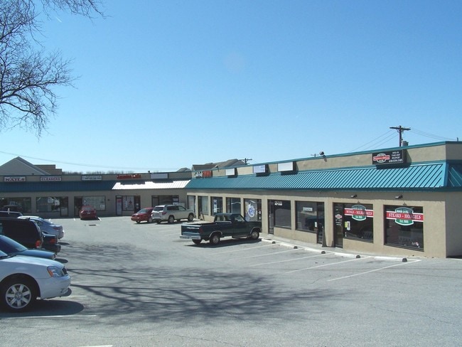
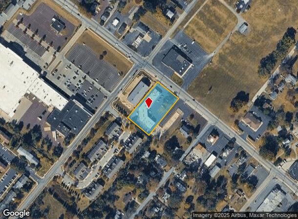
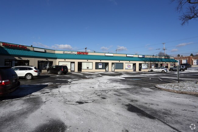
Property Record
3140 Ridge Pike, Norristown, PA 19403
NEARBY LISTINGS FOR SALE OR LEASE
Property Detail
3140 Ridge Pike
Philadelphia-Camden-Wilmington, PA-NJ-DE-MD
Ethal Kay Salter Estate
43-00-03216-062
166 X IRR 47872 SF
Storemultistory
Montgomery
X
Pennsylvania
42091C0245G
1
2024
1.10 AC
2025
Norristown/Valley Forge
206004
Philadelphia
13,887 SF
DEMOGRAPHICS near 3140 Ridge Pike
1 Mile
3 Mile
5 Mile
2024 Total Population
8,211
47,093
152,729
2029 Population
8,455
47,956
155,464
Pop Growth 2024-2029
+ 2.97%
+ 1.83%
+ 1.79%
Average Age
41
43
41
2024 Total Households
3,011
18,150
58,637
HH Growth 2024-2029
+ 3.09%
+ 1.80%
+ 1.88%
Median Household Inc
$118,087
$107,898
$97,021
Avg Household Size
2.70
2.40
2.50
2024 Avg HH Vehicles
2.00
2.00
2.00
Median Home Value
$412,098
$362,696
$355,868
Median Year Built
1976
1978
1974
Nearby Places
Map Layers
Map Styles
 Street
 Aerial
- Restaurants
- Banks
- Shops
- Fitness
- Groceries
PUBLIC TRANSPORTATION
COMMUTER RAIL
Main Street (Norristown) (R6 - Southeastern Pennsylvania Transportation Authority Regional Rail (SEPTA Regional Rail))
DRIVE
WALK
Distance
Main Street (Norristown) (R6 - Southeastern Pennsylvania Transportation Authority Regional Rail (SEPTA Regional Rail))
9 min
4.2 mi
Elm Street (Norristown) (R6 - Southeastern Pennsylvania Transportation Authority Regional Rail (SEPTA Regional Rail))
DRIVE
WALK
Distance
Elm Street (Norristown) (R6 - Southeastern Pennsylvania Transportation Authority Regional Rail (SEPTA Regional Rail))
10 min
4.6 mi
AIRPORT
Philadelphia International
DRIVE
WALK
Distance
Philadelphia International
52 min
33.0 mi
Freight Ports
Port of Philadelphia
DRIVE
WALK
Distance
Port of Philadelphia
47 min
30.3 mi
SALE & LEASE HISTORY
LISTING DATE
SALE/LEASE

Sep 25, 2016
For Lease
Sep 17, 2018
For Lease
May 22, 2023
For Lease
Jun 02, 2017
For Lease
Nearby Properties
Address
Land Use
TOTAL SIZE
Lot Size
Zoning
Address
Land Use
TOTAL SIZE
Lot Size
Zoning
124,789 SF
155.99 AC
INO
Address
Land Use
TOTAL SIZE
Lot Size
Zoning
972,935 SF
20.51 AC
INO
Address
Land Use
TOTAL SIZE
Lot Size
Zoning
422,975 SF
92.05 AC
RA
Address
Land Use
TOTAL SIZE
Lot Size
Zoning
348,190 SF
68 AC
R1
Address
Land Use
TOTAL SIZE
Lot Size
Zoning
1,470,449 SF
80.02 AC
R1
Address
Land Use
TOTAL SIZE
Lot Size
Zoning
199,873 SF
71.47 AC
INO
Address
Land Use
TOTAL SIZE
Lot Size
Zoning
367,115 SF
62.90 AC
AGR
Address
Land Use
TOTAL SIZE
Lot Size
Zoning
435,884 SF
26.70 AC
R5
Address
Land Use
TOTAL SIZE
Lot Size
Zoning
273,724 SF
8.05 AC
INO
Address
Land Use
TOTAL SIZE
Lot Size
Zoning
208,680 SF
4.54 AC
LCI
Address
Land Use
TOTAL SIZE
Lot Size
Zoning
305,760 SF
22.50 AC
R2
Address
Land Use
TOTAL SIZE
Lot Size
Zoning
252,272 SF
18.86 AC
A
Address
Land Use
TOTAL SIZE
Lot Size
Zoning
276,284 SF
3.87 AC
INO
Address
Land Use
TOTAL SIZE
Lot Size
Zoning
284,250 SF
17.10 AC
A
Address
Land Use
TOTAL SIZE
Lot Size
Zoning
234,091 SF
53.94 AC
PBO
Address
Land Use
TOTAL SIZE
Lot Size
Zoning
127,778 SF
13.43 AC
IP
Address
Land Use
TOTAL SIZE
Lot Size
Zoning
207,668 SF
4.96 AC
INO
Address
Land Use
TOTAL SIZE
Lot Size
Zoning
86,046 SF
12.03 AC
R1
Address
Land Use
TOTAL SIZE
Lot Size
Zoning
102,279 SF
17.15 AC
R1
Address
Land Use
TOTAL SIZE
Lot Size
Zoning
207,668 SF
4.13 AC
INO
Address
Land Use
TOTAL SIZE
Lot Size
Zoning
85,446 SF
14.60 AC
PF
Address
Land Use
TOTAL SIZE
Lot Size
Zoning
69,060 SF
18.68 AC
R1
Address
Land Use
TOTAL SIZE
Lot Size
Zoning
112,515 SF
3.23 AC
GC
Address
Land Use
TOTAL SIZE
Lot Size
Zoning
370,300 SF
7.33 AC
IP
Address
Land Use
TOTAL SIZE
Lot Size
Zoning
99,983 SF
10.41 AC
IP
Address
Land Use
TOTAL SIZE
Lot Size
Zoning
119,340 SF
10.91 AC
GC
Address
Land Use
TOTAL SIZE
Lot Size
Zoning
126,833 SF
11.92 AC
GC
Address
Land Use
TOTAL SIZE
Lot Size
Zoning
100,024 SF
8.64 AC
IP
Address
Land Use
TOTAL SIZE
Lot Size
Zoning
137,681 SF
39.94 AC
LCI
Address
Land Use
TOTAL SIZE
Lot Size
Zoning
137,689 SF
21.46 AC
GC
The World's #1 Commercial Real Estate Marketplace
Connect with us
© 2025 CoStar Group
The information above has been obtained from sources believed reliable. While we do not doubt its accuracy we have not verified it and make no guarantee, warranty or representation about it. It is your responsibility to independently confirm its accuracy and completeness. Any projections, opinions, assumptions, or estimates used are for example only and do not represent the current or future performance of the property. The value of this transaction to you depends on tax and other factors which should be evaluated by your tax, financial, and legal advisors. You and your advisors should conduct a careful, independent investigation of the property to determine to your satisfaction the suitability of the property for your needs.