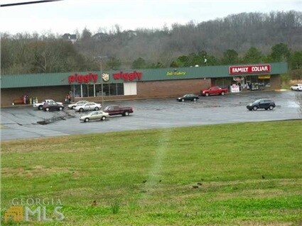
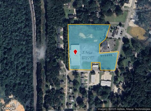
Property Record
3142 Maple Rd Se, Lindale, GA 30147
NEARBY LISTINGS FOR SALE OR LEASE
Property Detail
3142 Maple Rd Se
J16X-283
Rbg Rentals Llc
Supermarket
LLS70 & 75 22/3 PB35-24
X
Floyd
13115C0283F
Georgia
2024
6.92 AC
2024
Georgia Northwest
001703
Other Market Areas
29,287 SF
Rome, GA
DEMOGRAPHICS near 3142 Maple Rd Se
1 Mile
3 Mile
5 Mile
2024 Total Population
2,771
18,211
37,092
2029 Population
2,828
18,732
38,129
Pop Growth 2024-2029
+ 2.06%
+ 2.86%
+ 2.80%
Average Age
40
40
40
2024 Total Households
1,086
6,842
14,263
HH Growth 2024-2029
+ 2.03%
+ 2.98%
+ 2.90%
Median Household Inc
$42,982
$48,068
$52,863
Avg Household Size
2.50
2.40
2.40
2024 Avg HH Vehicles
2.00
2.00
2.00
Median Home Value
$158,563
$163,380
$202,323
Median Year Built
1960
1974
1973
Nearby Places
Map Layers
Map Styles
 Street
 Aerial
- Restaurants
- Banks
- Shops
- Fitness
- Groceries
Nearby Properties
Address
Land Use
TOTAL SIZE
Lot Size
Zoning
Address
Land Use
TOTAL SIZE
Lot Size
Zoning
425,450 SF
127.78 AC
H-I
Address
Land Use
TOTAL SIZE
Lot Size
Zoning
62,832 SF
H-I
Address
Land Use
TOTAL SIZE
Lot Size
Zoning
203,082 SF
22.05 AC
H-I
Address
Land Use
TOTAL SIZE
Lot Size
Zoning
1,980 SF
40.80 AC
H-I
Address
Land Use
TOTAL SIZE
Lot Size
Zoning
260,476 SF
51 AC
H-I
Address
Land Use
TOTAL SIZE
Lot Size
Zoning
17,904 SF
14.19 AC
H-I
Address
Land Use
TOTAL SIZE
Lot Size
Zoning
231,750 SF
25 AC
H-I
Address
Land Use
TOTAL SIZE
Lot Size
Zoning
6,998 SF
15 AC
M-R
Address
Land Use
TOTAL SIZE
Lot Size
Zoning
26.30 AC
H-I
Address
Land Use
TOTAL SIZE
Lot Size
Zoning
130.40 AC
O-I
Address
Land Use
TOTAL SIZE
Lot Size
Zoning
223.90 AC
O-I
Address
Land Use
TOTAL SIZE
Lot Size
Zoning
42,744 SF
11.10 AC
S-R
Address
Land Use
TOTAL SIZE
Lot Size
Zoning
15.20 AC
O-I
Address
Land Use
TOTAL SIZE
Lot Size
Zoning
72,880 SF
Address
Land Use
TOTAL SIZE
Lot Size
Zoning
257,573 SF
25.64 AC
H-I
Address
Land Use
TOTAL SIZE
Lot Size
Zoning
296 SF
9.46 AC
Address
Land Use
TOTAL SIZE
Lot Size
Zoning
1,598 SF
11.46 AC
M-R
Address
Land Use
TOTAL SIZE
Lot Size
Zoning
10.03 AC
O-I
Address
Land Use
TOTAL SIZE
Lot Size
Zoning
0.17 AC
H-T-R
Address
Land Use
TOTAL SIZE
Lot Size
Zoning
32,092 SF
2 AC
C-C
Address
Land Use
TOTAL SIZE
Lot Size
Zoning
47,136 SF
2 AC
C-C
Address
Land Use
TOTAL SIZE
Lot Size
Zoning
46,176 SF
9.88 AC
H-I
Address
Land Use
TOTAL SIZE
Lot Size
Zoning
79,954 SF
17.73 AC
H-I
Address
Land Use
TOTAL SIZE
Lot Size
Zoning
81,320 SF
28.66 AC
H-I
Address
Land Use
TOTAL SIZE
Lot Size
Zoning
9,088 SF
8.27 AC
M-R
Address
Land Use
TOTAL SIZE
Lot Size
Zoning
41,296 SF
3.01 AC
C-C
Address
Land Use
TOTAL SIZE
Lot Size
Zoning
72,000 SF
10 AC
Address
Land Use
TOTAL SIZE
Lot Size
Zoning
14,996 SF
4.21 AC
C-C
Address
Land Use
TOTAL SIZE
Lot Size
Zoning
23,484 SF
2 AC
C-C
Address
Land Use
TOTAL SIZE
Lot Size
Zoning
33,743 SF
6.93 AC
C-C
The World's #1 Commercial Real Estate Marketplace
Connect with us
© 2026 CoStar Group
The information above has been obtained from sources believed reliable. While we do not doubt its accuracy we have not verified it and make no guarantee, warranty or representation about it. It is your responsibility to independently confirm its accuracy and completeness. Any projections, opinions, assumptions, or estimates used are for example only and do not represent the current or future performance of the property. The value of this transaction to you depends on tax and other factors which should be evaluated by your tax, financial, and legal advisors. You and your advisors should conduct a careful, independent investigation of the property to determine to your satisfaction the suitability of the property for your needs.