Property Record
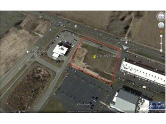
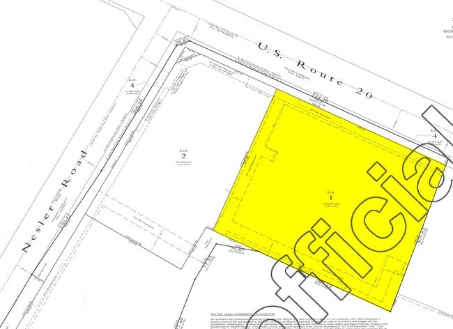
3145 Us Highway 20, Elgin, IL 60124
NEARBY LISTINGS FOR SALE OR LEASE
Property Detail
3145 Us Highway 20
Chicago-Naperville-Elgin, IL-IN
Good Sheperd Crossing
06-18-278-007
GOOD SHEPERD CROSSING PT OF LT 1 WITH 06-18-278-007 DUE TO TAXCODES
Commercialnec
Kane
X
Illinois
17089C0161H
1
2024
1.84 AC
2024
Western East/West Corr
8519051018
Chicago
DEMOGRAPHICS near 3145 Us Highway 20
1 mile
3 mile
5 mile
2024 Total Population
6,978
49,381
134,938
2029 Population
6,923
48,804
134,268
Pop Growth 2024-2029
(0.79%)
(1.17%)
(0.50%)
Average Age
37
41
39
2024 Total Households
2,215
17,285
46,267
HH Growth 2024-2029
(0.95%)
(1.23%)
(0.56%)
Median Household Inc
$138,884
$108,357
$96,783
Avg Household Size
3.10
2.80
2.80
2024 Avg HH Vehicles
2.00
2.00
2.00
Median Home Value
$342,315
$291,595
$268,560
Median Year Built
2003
1992
1987
Nearby Places
Map Layers
Map Styles
 Street
 Aerial
Transit
 Traffic
 Biking
Places
Listings with unknown addresses are not visible on the map
- Restaurants
- Banks
- Shops
- Fitness
- Groceries
PUBLIC TRANSPORTATION
COMMUTER RAIL
Elgin Station (Milwaukee District West Line - Northeast Illinois Regional Commuter Railroad (Metra))
Drive
Walk
Distance
Elgin Station (Milwaukee District West Line - Northeast Illinois Regional Commuter Railroad (Metra))
9 min
4.2 mi
Big Timber Road Station (Milwaukee District West Line - Northeast Illinois Regional Commuter Railroad (Metra))
Drive
Walk
Distance
Big Timber Road Station (Milwaukee District West Line - Northeast Illinois Regional Commuter Railroad (Metra))
9 min
4.6 mi
AIRPORT
Chicago O'Hare International
Drive
Walk
Distance
Chicago O'Hare International
42 min
31.7 mi
Chicago Midway International
Drive
Walk
Distance
Chicago Midway International
61 min
42.7 mi
Nearby Properties
Address
Land Use
TOTAL SIZE
Lot Size
Zoning
Address
Land Use
TOTAL SIZE
Lot Size
Zoning
37.65 AC
Address
Land Use
TOTAL SIZE
Lot Size
Zoning
14.36 AC
Address
Land Use
TOTAL SIZE
Lot Size
Zoning
20.93 AC
Address
Land Use
TOTAL SIZE
Lot Size
Zoning
18.55 AC
Address
Land Use
TOTAL SIZE
Lot Size
Zoning
522,133 SF
16 AC
Address
Land Use
TOTAL SIZE
Lot Size
Zoning
14.01 AC
Address
Land Use
TOTAL SIZE
Lot Size
Zoning
99,800 SF
0.53 AC
Address
Land Use
TOTAL SIZE
Lot Size
Zoning
10.87 AC
Address
Land Use
TOTAL SIZE
Lot Size
Zoning
238,115 SF
21.61 AC
Address
Land Use
TOTAL SIZE
Lot Size
Zoning
35,808 SF
11.40 AC
Address
Land Use
TOTAL SIZE
Lot Size
Zoning
19.06 AC
Address
Land Use
TOTAL SIZE
Lot Size
Zoning
7,254 SF
1.98 AC
Address
Land Use
TOTAL SIZE
Lot Size
Zoning
217,848 SF
9.81 AC
Address
Land Use
TOTAL SIZE
Lot Size
Zoning
76,884 SF
2.87 AC
Address
Land Use
TOTAL SIZE
Lot Size
Zoning
2.48 AC
Address
Land Use
TOTAL SIZE
Lot Size
Zoning
11.07 AC
Address
Land Use
TOTAL SIZE
Lot Size
Zoning
186,692 SF
19.48 AC
Address
Land Use
TOTAL SIZE
Lot Size
Zoning
0.20 AC
Address
Land Use
TOTAL SIZE
Lot Size
Zoning
9.11 AC
Address
Land Use
TOTAL SIZE
Lot Size
Zoning
99,903 SF
6.49 AC
Address
Land Use
TOTAL SIZE
Lot Size
Zoning
8.98 AC
Address
Land Use
TOTAL SIZE
Lot Size
Zoning
10.03 AC
Address
Land Use
TOTAL SIZE
Lot Size
Zoning
Address
Land Use
TOTAL SIZE
Lot Size
Zoning
179,857 SF
4.60 AC
Address
Land Use
TOTAL SIZE
Lot Size
Zoning
146,694 SF
10.25 AC
Address
Land Use
TOTAL SIZE
Lot Size
Zoning
66,000 SF
5.20 AC
Address
Land Use
TOTAL SIZE
Lot Size
Zoning
0.70 AC
Address
Land Use
TOTAL SIZE
Lot Size
Zoning
Address
Land Use
TOTAL SIZE
Lot Size
Zoning
7.51 AC
The World's #1 Commercial Real Estate Marketplace
Connect with us
© 2026 CoStar Group
The information above has been obtained from sources believed reliable. While we do not doubt its accuracy we have not verified it and make no guarantee, warranty or representation about it. It is your responsibility to independently confirm its accuracy and completeness. Any projections, opinions, assumptions, or estimates used are for example only and do not represent the current or future performance of the property. The value of this transaction to you depends on tax and other factors which should be evaluated by your tax, financial, and legal advisors. You and your advisors should conduct a careful, independent investigation of the property to determine to your satisfaction the suitability of the property for your needs.