Property Record
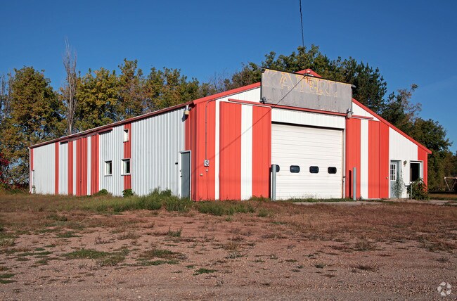
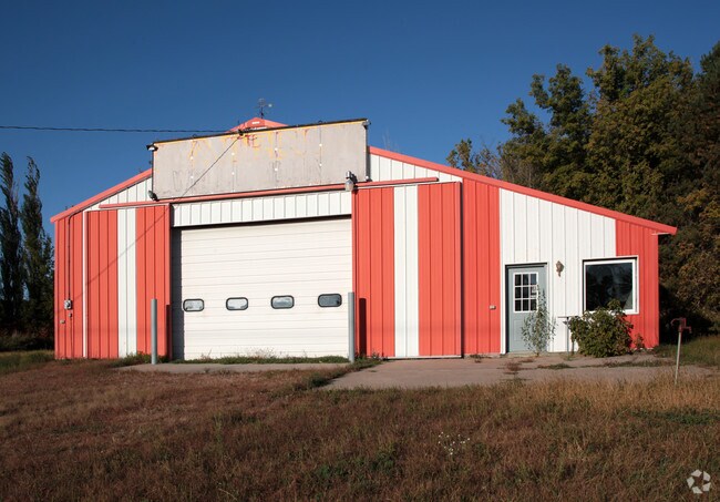
31498 State Highway 13, New Prague, MN 56071

Property Detail
31498 State Highway 13
Minneapolis-St. Paul-Bloomington, MN-WI
SECT-21 TWP-112 RANGE-023 1.37 AC THAT PART OF SE 1/4 OF NE 1/4 BEG AT E 1/4 COR OF SEC 21, TH W 200 FT, N 108 FT, W 48.85FT,
07.999.0080
LE SUEUR
Policefirecivildefense
Minnesota
B and X Area of moderate flood hazard, usually the area between the limits of the 100-year and 500-year floods.
1.37 AC
2025
Le Sueur County
2025
Other Market Areas
950102
NEARBY LISTINGS FOR SALE OR LEASE
-
-
View all New Prague listings for sale on LoopNet.com
DEMOGRAPHICS near 31498 State Highway 13
1 mile
3 mile
5 mile
2024 Total Population
150
2,584
14,790
2029 Population
151
2,608
15,060
Pop Growth 2024-2029
+ 0.67%
+ 0.93%
+ 1.83%
Average Age
40
40
39
2024 Total Households
53
919
5,568
HH Growth 2024-2029
0.00%
+ 0.87%
+ 1.85%
Median Household Inc
$116,666
$111,111
$91,104
Avg Household Size
2.70
2.80
2.60
2024 Avg HH Vehicles
3.00
3.00
2.00
Median Home Value
$426,923
$411,211
$352,249
Median Year Built
1991
1991
1988
Nearby Places
Map Layers
Map Styles
 Street
 Aerial
Transit
 Traffic
 Biking
Places
Listings with unknown addresses are not visible on the map
- Restaurants
- Banks
- Shops
- Fitness
- Groceries
PUBLIC TRANSPORTATION
AIRPORT
Minneapolis-St Paul International/Wold-Chamberlain
Drive
Walk
Distance
Minneapolis-St Paul International/Wold-Chamberlain
60 min
44.2 mi
Nearby Properties
Address
Land Use
TOTAL SIZE
Lot Size
Zoning
Address
Land Use
TOTAL SIZE
Lot Size
Zoning
2,028 SF
110 AC
Address
Land Use
TOTAL SIZE
Lot Size
Zoning
108.36 AC
Address
Land Use
TOTAL SIZE
Lot Size
Zoning
116.38 AC
Address
Land Use
TOTAL SIZE
Lot Size
Zoning
2,210 SF
80 AC
Address
Land Use
TOTAL SIZE
Lot Size
Zoning
46,238 SF
4.45 AC
Address
Land Use
TOTAL SIZE
Lot Size
Zoning
Address
Land Use
TOTAL SIZE
Lot Size
Zoning
1,997 SF
80 AC
Address
Land Use
TOTAL SIZE
Lot Size
Zoning
1,604 SF
80 AC
Address
Land Use
TOTAL SIZE
Lot Size
Zoning
1,723 SF
102.69 AC
Address
Land Use
TOTAL SIZE
Lot Size
Zoning
1,431 SF
68.53 AC
Address
Land Use
TOTAL SIZE
Lot Size
Zoning
3,098 SF
23.29 AC
Address
Land Use
TOTAL SIZE
Lot Size
Zoning
2,214 SF
63.50 AC
Address
Land Use
TOTAL SIZE
Lot Size
Zoning
2,768 SF
47.53 AC
Address
Land Use
TOTAL SIZE
Lot Size
Zoning
1,418 SF
85.97 AC
Address
Land Use
TOTAL SIZE
Lot Size
Zoning
2,651 SF
53.39 AC
Address
Land Use
TOTAL SIZE
Lot Size
Zoning
3,046 SF
30.23 AC
Address
Land Use
TOTAL SIZE
Lot Size
Zoning
3,035 SF
40.75 AC
Address
Land Use
TOTAL SIZE
Lot Size
Zoning
3,567 SF
22.10 AC
Address
Land Use
TOTAL SIZE
Lot Size
Zoning
1,109 SF
73.75 AC
Address
Land Use
TOTAL SIZE
Lot Size
Zoning
38.65 AC
Address
Land Use
TOTAL SIZE
Lot Size
Zoning
2,023 SF
8.38 AC
Address
Land Use
TOTAL SIZE
Lot Size
Zoning
2,147 SF
42.57 AC
Address
Land Use
TOTAL SIZE
Lot Size
Zoning
3,143 SF
24.17 AC
Address
Land Use
TOTAL SIZE
Lot Size
Zoning
82.50 AC
Address
Land Use
TOTAL SIZE
Lot Size
Zoning
1,433 SF
80 AC
Address
Land Use
TOTAL SIZE
Lot Size
Zoning
2,699 SF
16.55 AC
Address
Land Use
TOTAL SIZE
Lot Size
Zoning
1,950 SF
75 AC
Address
Land Use
TOTAL SIZE
Lot Size
Zoning
1,995 SF
40.54 AC
Address
Land Use
TOTAL SIZE
Lot Size
Zoning
1,958 SF
48.06 AC
Address
Land Use
TOTAL SIZE
Lot Size
Zoning
The World's #1 Commercial Real Estate Marketplace
Connect with us
© 2026 CoStar Group
The information above has been obtained from sources believed reliable. While we do not doubt its accuracy we have not verified it and make no guarantee, warranty or representation about it. It is your responsibility to independently confirm its accuracy and completeness. Any projections, opinions, assumptions, or estimates used are for example only and do not represent the current or future performance of the property. The value of this transaction to you depends on tax and other factors which should be evaluated by your tax, financial, and legal advisors. You and your advisors should conduct a careful, independent investigation of the property to determine to your satisfaction the suitability of the property for your needs.