Property Record
315 65Th St E, Bradenton, FL 34208
Save to a Folder
{{folder.Name}}
{{folder.ListingIds.length}} Properties
{{folder.ListingIds.length}} Property
Create a New Folder
Property Detail
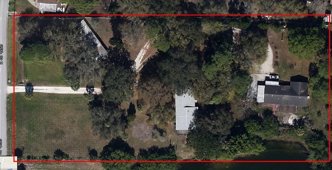
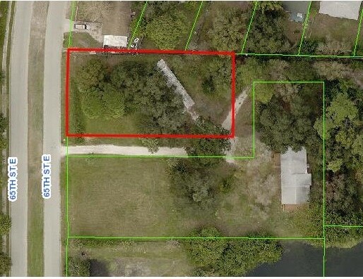
315 65Th St E
11088-1010-0
COM AT NELY MOST INTERSEC OF 65TH ST E & SR 64 IN W1/2 OF SEC 26; TH N 0 DEG 04 MIN 30 SEC E, ALG E R/W OF 65TH ST E, A DIST OF 601.41 FT FOR THE POB; TH CONT N 0 DEG 04 MIN 30
Residentialacreage
Manatee
PD-R
Florida
B and X Area of moderate flood hazard, usually the area between the limits of the 100-year and 500-year floods.
0.56 AC
2025
Manatee
2026
Tampa/St Petersburg
002003
North Port-Bradenton-Sarasota, FL
1,620 SF
NEARBY LISTINGS FOR SALE OR LEASE
DEMOGRAPHICS near 315 65Th St E
1 mile
3 mile
5 mile
2025 Total Population
4,943
34,323
135,947
2030 Population
5,474
38,439
152,661
Pop Growth 2025-2030
+ 10.74%
+ 11.99%
+ 12.29%
Average Age
40
48
46
2025 Total Households
2,091
15,285
55,725
HH Growth 2025-2030
+ 11.05%
+ 12.18%
+ 12.57%
Median Household Inc
$95,285
$93,496
$89,031
Avg Household Size
2.40
2.20
2.40
2025 Avg HH Vehicles
2.00
2.00
2.00
Median Home Value
$392,552
$459,723
$436,640
Median Year Built
2008
2004
2003
Nearby Places
Map Layers
Map Styles
 Street
 Aerial
Layers
 Traffic
 Biking
Places
Listings with unknown addresses are not visible on the map
- Restaurants
- Banks
- Shops
- Fitness
- Groceries
PUBLIC TRANSPORTATION
AIRPORT
Sarasota/Bradenton International
Drive
Walk
Distance
Sarasota/Bradenton International
26 min
16.0 mi
Freight Ports
Port Manatee
Drive
Walk
Distance
Port Manatee
24 min
14.3 mi
SALE & LEASE HISTORY
LISTING DATE
SALE/LEASE

Aug 17, 2017
For Lease
Nearby Properties
Address
Land Use
TOTAL SIZE
Lot Size
Zoning
Address
Land Use
TOTAL SIZE
Lot Size
Zoning
881,490 SF
83.09 AC
BR_R-3
Address
Land Use
TOTAL SIZE
Lot Size
Zoning
513,465 SF
78.39 AC
PD-MU
Address
Land Use
TOTAL SIZE
Lot Size
Zoning
628,167 SF
16.77 AC
PD-MU
Address
Land Use
TOTAL SIZE
Lot Size
Zoning
438,700 SF
10.45 AC
Address
Land Use
TOTAL SIZE
Lot Size
Zoning
707,409 SF
27.98 AC
PD-MU
Address
Land Use
TOTAL SIZE
Lot Size
Zoning
282,022 SF
21.30 AC
GC GENERA
Address
Land Use
TOTAL SIZE
Lot Size
Zoning
319,679 SF
31.78 AC
BR_R-1
Address
Land Use
TOTAL SIZE
Lot Size
Zoning
293,332 SF
50.52 AC
A-1 SUBURB
Address
Land Use
TOTAL SIZE
Lot Size
Zoning
311,669 SF
34.55 AC
BR_R-2
Address
Land Use
TOTAL SIZE
Lot Size
Zoning
225,768 SF
18.47 AC
BR_R-1
Address
Land Use
TOTAL SIZE
Lot Size
Zoning
89,137 SF
11.61 AC
Address
Land Use
TOTAL SIZE
Lot Size
Zoning
348,901 SF
27 AC
BR_R-2
Address
Land Use
TOTAL SIZE
Lot Size
Zoning
29,566 SF
1.17 AC
PD-PI
Address
Land Use
TOTAL SIZE
Lot Size
Zoning
191,100 SF
30.35 AC
PD-C
Address
Land Use
TOTAL SIZE
Lot Size
Zoning
160,163 SF
16.35 AC
PD-MU
Address
Land Use
TOTAL SIZE
Lot Size
Zoning
110,462 SF
12.91 AC
PD-MU
Address
Land Use
TOTAL SIZE
Lot Size
Zoning
220,706 SF
24.13 AC
PD-C, A-1
Address
Land Use
TOTAL SIZE
Lot Size
Zoning
58,946 SF
13.62 AC
GC GENERA
Address
Land Use
TOTAL SIZE
Lot Size
Zoning
149,048 SF
15.67 AC
PD-MU
Address
Land Use
TOTAL SIZE
Lot Size
Zoning
13,621 SF
61.72 AC
PD-RV,RSF-
Address
Land Use
TOTAL SIZE
Lot Size
Zoning
201,982 SF
16.65 AC
BR_SCC
Address
Land Use
TOTAL SIZE
Lot Size
Zoning
132,000 SF
3.15 AC
PD-C
Address
Land Use
TOTAL SIZE
Lot Size
Zoning
92,466 SF
18.80 AC
A-1 SUBURB
Address
Land Use
TOTAL SIZE
Lot Size
Zoning
61,770 SF
79.85 AC
A,A-1
Address
Land Use
TOTAL SIZE
Lot Size
Zoning
138,535 SF
13.94 AC
BR_SCC
Address
Land Use
TOTAL SIZE
Lot Size
Zoning
35,784 SF
Address
Land Use
TOTAL SIZE
Lot Size
Zoning
91,918 SF
6.03 AC
PD-C
Address
Land Use
TOTAL SIZE
Lot Size
Zoning
63,563 SF
4.44 AC
Address
Land Use
TOTAL SIZE
Lot Size
Zoning
47,241 SF
15.63 AC
A-1 SUBURB
Address
Land Use
TOTAL SIZE
Lot Size
Zoning
42,905 SF
6.17 AC
PD-C
The World's #1 Commercial Real Estate Marketplace
Connect with us
© 2026 CoStar Group
The information above has been obtained from sources believed reliable. While we do not doubt its accuracy we have not verified it and make no guarantee, warranty or representation about it. It is your responsibility to independently confirm its accuracy and completeness. Any projections, opinions, assumptions, or estimates used are for example only and do not represent the current or future performance of the property. The value of this transaction to you depends on tax and other factors which should be evaluated by your tax, financial, and legal advisors. You and your advisors should conduct a careful, independent investigation of the property to determine to your satisfaction the suitability of the property for your needs.