Property Record
315 9Th St, Wenatchee, WA 98801
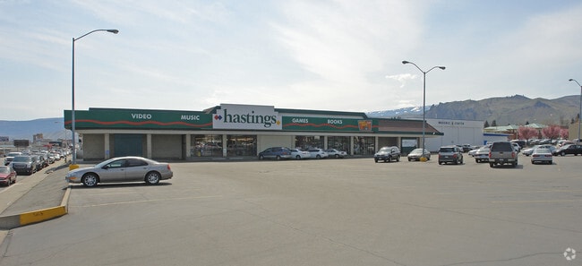


Property Detail
315 9Th St
Wenatchee-East Wenatchee, WA
SUBURBAN HOMES FIRST BLOCK 17 LOT 1-4 TRACT 2 2.4600 ACRES TRACT 2
18392
CHELAN
Supermarket
Washington
2025
1-4
2025
2.46 AC
960803
Washington State Area
31,836 SF
Other Market Areas
NEARBY LISTINGS FOR SALE OR LEASE
DEMOGRAPHICS near 315 9Th St
1 mile
3 mile
5 mile
2025 Total Population
11,034
55,623
73,146
2030 Population
11,050
56,622
74,911
Pop Growth 2025-2030
+ 0.15%
+ 1.80%
+ 2.41%
Average Age
39
40
40
2025 Total Households
4,599
21,016
27,129
HH Growth 2025-2030
(0.02%)
+ 1.74%
+ 2.34%
Median Household Inc
$69,067
$78,297
$81,941
Avg Household Size
2.30
2.50
2.60
2025 Avg HH Vehicles
2.00
2.00
2.00
Median Home Value
$392,008
$453,806
$460,718
Median Year Built
1972
1978
1980
Nearby Places
Map Layers
Map Styles
 Street
 Aerial
Transit
 Traffic
 Biking
Places
Listings with unknown addresses are not visible on the map
- Restaurants
- Banks
- Shops
- Fitness
- Groceries
PUBLIC TRANSPORTATION
COMMUTER RAIL
Wenatchee Amtrak (Empire Builder - Amtrak)
Drive
Walk
Distance
Wenatchee Amtrak (Empire Builder - Amtrak)
4 min
1.4 mi
AIRPORT
Pangborn Memorial
Drive
Walk
Distance
Pangborn Memorial
17 min
7.5 mi
Freight Ports
Port of Seattle
Drive
Walk
Distance
Port of Seattle
184 min
149.6 mi
Nearby Properties
Address
Land Use
TOTAL SIZE
Lot Size
Zoning
Address
Land Use
TOTAL SIZE
Lot Size
Zoning
309,324 SF
6.84 AC
Address
Land Use
TOTAL SIZE
Lot Size
Zoning
419,838 SF
14.62 AC
Address
Land Use
TOTAL SIZE
Lot Size
Zoning
198,833 SF
9.52 AC
Address
Land Use
TOTAL SIZE
Lot Size
Zoning
149,177 SF
2.55 AC
Address
Land Use
TOTAL SIZE
Lot Size
Zoning
128,905 SF
8.32 AC
Address
Land Use
TOTAL SIZE
Lot Size
Zoning
197,755 SF
8.35 AC
R-M
Address
Land Use
TOTAL SIZE
Lot Size
Zoning
133,259 SF
11.43 AC
2
Address
Land Use
TOTAL SIZE
Lot Size
Zoning
104,070 SF
3.11 AC
Address
Land Use
TOTAL SIZE
Lot Size
Zoning
111,946 SF
2 AC
Address
Land Use
TOTAL SIZE
Lot Size
Zoning
56,645 SF
6.35 AC
Address
Land Use
TOTAL SIZE
Lot Size
Zoning
73,830 SF
6.29 AC
Address
Land Use
TOTAL SIZE
Lot Size
Zoning
91,804 SF
10.26 AC
Address
Land Use
TOTAL SIZE
Lot Size
Zoning
103,995 SF
5.51 AC
Address
Land Use
TOTAL SIZE
Lot Size
Zoning
55,723 SF
1.86 AC
2
Address
Land Use
TOTAL SIZE
Lot Size
Zoning
159,039 SF
16.21 AC
Address
Land Use
TOTAL SIZE
Lot Size
Zoning
203,732 SF
11.16 AC
2
Address
Land Use
TOTAL SIZE
Lot Size
Zoning
108,000 SF
7.05 AC
Address
Land Use
TOTAL SIZE
Lot Size
Zoning
143,166 SF
13.44 AC
2
Address
Land Use
TOTAL SIZE
Lot Size
Zoning
109,475 SF
9 AC
Address
Land Use
TOTAL SIZE
Lot Size
Zoning
168,028 SF
21.20 AC
Address
Land Use
TOTAL SIZE
Lot Size
Zoning
57,520 SF
3.52 AC
Address
Land Use
TOTAL SIZE
Lot Size
Zoning
95,460 SF
5.80 AC
Address
Land Use
TOTAL SIZE
Lot Size
Zoning
67,932 SF
5.58 AC
Address
Land Use
TOTAL SIZE
Lot Size
Zoning
42,032 SF
4.27 AC
Address
Land Use
TOTAL SIZE
Lot Size
Zoning
148,977 SF
11.06 AC
Address
Land Use
TOTAL SIZE
Lot Size
Zoning
142,150 SF
10.46 AC
Address
Land Use
TOTAL SIZE
Lot Size
Zoning
52,894 SF
1.50 AC
2
Address
Land Use
TOTAL SIZE
Lot Size
Zoning
56,105 SF
6.03 AC
Address
Land Use
TOTAL SIZE
Lot Size
Zoning
71,846 SF
2.28 AC
Address
Land Use
TOTAL SIZE
Lot Size
Zoning
89,736 SF
6.96 AC
The World's #1 Commercial Real Estate Marketplace
Connect with us
© 2026 CoStar Group
The information above has been obtained from sources believed reliable. While we do not doubt its accuracy we have not verified it and make no guarantee, warranty or representation about it. It is your responsibility to independently confirm its accuracy and completeness. Any projections, opinions, assumptions, or estimates used are for example only and do not represent the current or future performance of the property. The value of this transaction to you depends on tax and other factors which should be evaluated by your tax, financial, and legal advisors. You and your advisors should conduct a careful, independent investigation of the property to determine to your satisfaction the suitability of the property for your needs.