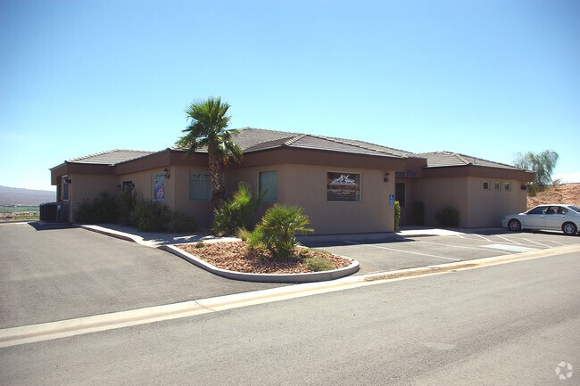
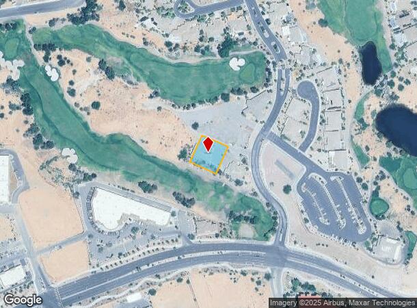
Property Record
315 Calais Dr, Mesquite, NV 89027
NEARBY LISTINGS FOR SALE OR LEASE
-
-
View all Mesquite listings for sale on LoopNet.com
Property Detail
315 Calais Dr
Las Vegas-Henderson-North Las Vegas, NV
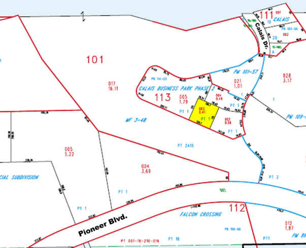
Calais Business Park Phase 2
001-18-113-003
CALAIS BUSINESS PARK PHASE 2 PLAT BOOK 114 PAGE 23 PT LOT 1
Commercialnec
Clark
X
Nevada
04015C0400G
1
2025
0.41 AC
2025
Outlying NE Clark County
005904
Las Vegas
3,489 SF
DEMOGRAPHICS near 315 Calais Dr
1 Mile
3 Mile
5 Mile
2024 Total Population
3,319
25,302
26,987
2029 Population
3,706
28,008
29,828
Pop Growth 2024-2029
+ 11.66%
+ 10.69%
+ 10.53%
Average Age
59
54
54
2024 Total Households
1,587
11,546
12,355
HH Growth 2024-2029
+ 11.85%
+ 10.89%
+ 10.72%
Median Household Inc
$71,699
$66,707
$65,709
Avg Household Size
2.00
2.10
2.10
2024 Avg HH Vehicles
2.00
2.00
2.00
Median Home Value
$394,147
$371,044
$369,291
Median Year Built
2009
2005
2004
Nearby Places
Map Layers
Map Styles
 Street
 Aerial
- Restaurants
- Banks
- Shops
- Fitness
- Groceries
PUBLIC TRANSPORTATION
AIRPORT
St George Regional
DRIVE
WALK
Distance
St George Regional
54 min
42.6 mi
SALE & LEASE HISTORY
LISTING DATE
SALE/LEASE

Jul 14, 2018
For Sale
Nearby Properties
Address
Land Use
TOTAL SIZE
Lot Size
Zoning
Address
Land Use
TOTAL SIZE
Lot Size
Zoning
148,373 SF
19.35 AC
HT
Address
Land Use
TOTAL SIZE
Lot Size
Zoning
568,590 SF
63.57 AC
Address
Land Use
TOTAL SIZE
Lot Size
Zoning
197,938 SF
35.63 AC
HT
Address
Land Use
TOTAL SIZE
Lot Size
Zoning
123,397 SF
26.60 AC
HT
Address
Land Use
TOTAL SIZE
Lot Size
Zoning
568,553 SF
56.06 AC
IR1
Address
Land Use
TOTAL SIZE
Lot Size
Zoning
83,429 SF
23.92 AC
CRH
Address
Land Use
TOTAL SIZE
Lot Size
Zoning
496,775 SF
5.02 AC
HT
Address
Land Use
TOTAL SIZE
Lot Size
Zoning
37.78 AC
PROS
Address
Land Use
TOTAL SIZE
Lot Size
Zoning
12.49 AC
PF
Address
Land Use
TOTAL SIZE
Lot Size
Zoning
154,961 SF
17.17 AC
PUD
Address
Land Use
TOTAL SIZE
Lot Size
Zoning
107,554 SF
10.04 AC
Address
Land Use
TOTAL SIZE
Lot Size
Zoning
10.09 AC
PF
Address
Land Use
TOTAL SIZE
Lot Size
Zoning
81,518 SF
1.87 AC
PUD
Address
Land Use
TOTAL SIZE
Lot Size
Zoning
67,184 SF
14.69 AC
HT
Address
Land Use
TOTAL SIZE
Lot Size
Zoning
3,450 SF
4.93 AC
PB
Address
Land Use
TOTAL SIZE
Lot Size
Zoning
6,831 SF
6.01 AC
CR2
Address
Land Use
TOTAL SIZE
Lot Size
Zoning
111,642 SF
8.35 AC
IR1
Address
Land Use
TOTAL SIZE
Lot Size
Zoning
47,328 SF
4.65 AC
CR2
Address
Land Use
TOTAL SIZE
Lot Size
Zoning
66,537 SF
6.27 AC
PUD
Address
Land Use
TOTAL SIZE
Lot Size
Zoning
1,056 SF
5.96 AC
MF4
Address
Land Use
TOTAL SIZE
Lot Size
Zoning
60,114 SF
5.54 AC
HT
Address
Land Use
TOTAL SIZE
Lot Size
Zoning
13,286 SF
1.63 AC
Address
Land Use
TOTAL SIZE
Lot Size
Zoning
4.11 AC
CR3
Address
Land Use
TOTAL SIZE
Lot Size
Zoning
11,249 SF
220.36 AC
PUD
Address
Land Use
TOTAL SIZE
Lot Size
Zoning
52,240 SF
3.74 AC
CR2
Address
Land Use
TOTAL SIZE
Lot Size
Zoning
36,233 SF
3.31 AC
PUD
The World's #1 Commercial Real Estate Marketplace
Connect with us
© 2026 CoStar Group
The information above has been obtained from sources believed reliable. While we do not doubt its accuracy we have not verified it and make no guarantee, warranty or representation about it. It is your responsibility to independently confirm its accuracy and completeness. Any projections, opinions, assumptions, or estimates used are for example only and do not represent the current or future performance of the property. The value of this transaction to you depends on tax and other factors which should be evaluated by your tax, financial, and legal advisors. You and your advisors should conduct a careful, independent investigation of the property to determine to your satisfaction the suitability of the property for your needs.