Property Record
315 E 2Nd St, Boyertown, PA 19512
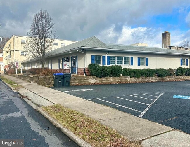

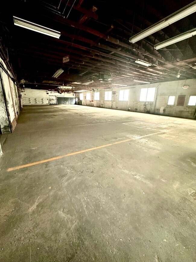
This Property Is For Sale
Current Lease Availabilities
Property Detail
315 E 2Nd St
33-5386-08-99-4614
Berks
Warehouse
Pennsylvania
B and X Area of moderate flood hazard, usually the area between the limits of the 100-year and 500-year floods.
2.08 AC
2026
Berks
2026
Philadelphia
013200
Reading, PA
81,293 SF
NEARBY LISTINGS FOR SALE OR LEASE
DEMOGRAPHICS near 315 E 2Nd St
1 mile
3 mile
5 mile
2025 Total Population
7,239
25,666
55,435
2030 Population
7,334
26,185
56,540
Pop Growth 2025-2030
+ 1.31%
+ 2.02%
+ 1.99%
Average Age
42
42
42
2025 Total Households
3,130
9,857
20,998
HH Growth 2025-2030
+ 1.34%
+ 1.97%
+ 1.96%
Median Household Inc
$68,865
$94,338
$101,640
Avg Household Size
2.30
2.60
2.60
2025 Avg HH Vehicles
2.00
2.00
2.00
Median Home Value
$231,283
$335,258
$340,842
Median Year Built
1957
1974
1975
Nearby Places
Map Layers
Map Styles
 Street
 Aerial
Layers
 Traffic
 Biking
Places
Listings with unknown addresses are not visible on the map
- Restaurants
- Banks
- Shops
- Fitness
- Groceries
PUBLIC TRANSPORTATION
AIRPORT
Lehigh Valley International
Drive
Walk
Distance
Lehigh Valley International
52 min
27.3 mi
Nearby Properties
Address
Land Use
TOTAL SIZE
Lot Size
Zoning
Address
Land Use
TOTAL SIZE
Lot Size
Zoning
165,799 SF
68.37 AC
R50
Address
Land Use
TOTAL SIZE
Lot Size
Zoning
57,000 SF
5.98 AC
M1
Address
Land Use
TOTAL SIZE
Lot Size
Zoning
89,618 SF
11.02 AC
M1
Address
Land Use
TOTAL SIZE
Lot Size
Zoning
71,093 SF
2.64 AC
Address
Land Use
TOTAL SIZE
Lot Size
Zoning
88,494 SF
27.29 AC
IN
Address
Land Use
TOTAL SIZE
Lot Size
Zoning
188,596 SF
24.21 AC
Address
Land Use
TOTAL SIZE
Lot Size
Zoning
199,496 SF
20.55 AC
M1
Address
Land Use
TOTAL SIZE
Lot Size
Zoning
47,136 SF
2.49 AC
Address
Land Use
TOTAL SIZE
Lot Size
Zoning
90,925 SF
9.33 AC
GC
Address
Land Use
TOTAL SIZE
Lot Size
Zoning
42,336 SF
4.28 AC
R4
Address
Land Use
TOTAL SIZE
Lot Size
Zoning
83,400 SF
11.34 AC
GC
Address
Land Use
TOTAL SIZE
Lot Size
Zoning
224,550 SF
21.20 AC
Address
Land Use
TOTAL SIZE
Lot Size
Zoning
90,648 SF
19.58 AC
R4
Address
Land Use
TOTAL SIZE
Lot Size
Zoning
113,341 SF
11.03 AC
Address
Land Use
TOTAL SIZE
Lot Size
Zoning
22,296 SF
2.69 AC
M1
Address
Land Use
TOTAL SIZE
Lot Size
Zoning
48,320 SF
5 AC
GC
Address
Land Use
TOTAL SIZE
Lot Size
Zoning
40,751 SF
12.78 AC
IN
Address
Land Use
TOTAL SIZE
Lot Size
Zoning
65,162 SF
9.05 AC
GC
Address
Land Use
TOTAL SIZE
Lot Size
Zoning
44,060 SF
24.54 AC
Address
Land Use
TOTAL SIZE
Lot Size
Zoning
78,000 SF
9.44 AC
M1
Address
Land Use
TOTAL SIZE
Lot Size
Zoning
236,153 SF
30.47 AC
M2
Address
Land Use
TOTAL SIZE
Lot Size
Zoning
20,460 SF
3.50 AC
R4
Address
Land Use
TOTAL SIZE
Lot Size
Zoning
264,545 SF
17.18 AC
Address
Land Use
TOTAL SIZE
Lot Size
Zoning
161,138 SF
160.99 AC
Address
Land Use
TOTAL SIZE
Lot Size
Zoning
73,397 SF
4.36 AC
M1
Address
Land Use
TOTAL SIZE
Lot Size
Zoning
19,632 SF
4.31 AC
IN
Address
Land Use
TOTAL SIZE
Lot Size
Zoning
15,296 SF
6.96 AC
IN
Address
Land Use
TOTAL SIZE
Lot Size
Zoning
18,920 SF
6.17 AC
GC
Address
Land Use
TOTAL SIZE
Lot Size
Zoning
20,388 SF
2.70 AC
Address
Land Use
TOTAL SIZE
Lot Size
Zoning
23,118 SF
2.09 AC
R4
The World's #1 Commercial Real Estate Marketplace
Connect with us
© 2026 CoStar Group
The information above has been obtained from sources believed reliable. While we do not doubt its accuracy we have not verified it and make no guarantee, warranty or representation about it. It is your responsibility to independently confirm its accuracy and completeness. Any projections, opinions, assumptions, or estimates used are for example only and do not represent the current or future performance of the property. The value of this transaction to you depends on tax and other factors which should be evaluated by your tax, financial, and legal advisors. You and your advisors should conduct a careful, independent investigation of the property to determine to your satisfaction the suitability of the property for your needs.