Property Record
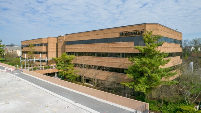
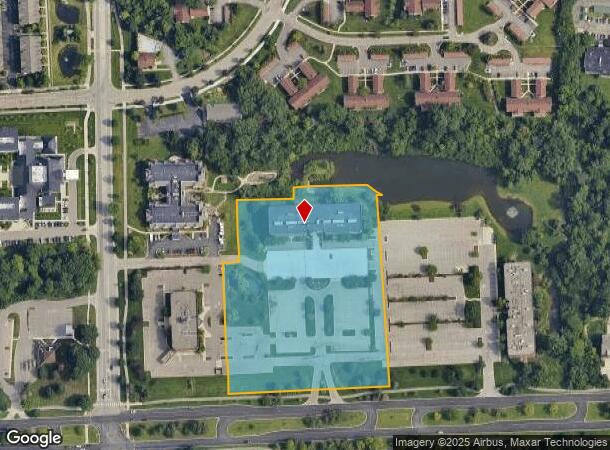
315 E Eisenhower Pky, Ann Arbor, MI 48108

Current Lease Availabilities
NEARBY LISTINGS FOR SALE OR LEASE
Property Detail
315 E Eisenhower Pky
12-05-400-154
Burlington Office Center Condominium
Commercialnec
PRT OF SE 1/4 OF SEC 5, T3S, R6E, DESC AS COM AT S 1/4 COR OF SD SEC 5, TH N 87 DEG 25' 50 E 344.48 FT TO THE POB; TH N 02
AE
Washtenaw
26161C0401E
Michigan
2025
6.06 AC
2025
Washtenaw W of 23
404500
Detroit
119,564 SF
Ann Arbor, MI
DEMOGRAPHICS near 315 E Eisenhower Pky
1 Mile
3 Mile
5 Mile
2024 Total Population
7,849
92,051
168,774
2029 Population
7,786
91,047
166,932
Pop Growth 2024-2029
(0.80%)
(1.09%)
(1.09%)
Average Age
40
36
37
2024 Total Households
4,218
38,036
70,156
HH Growth 2024-2029
(0.88%)
(1.05%)
(1.10%)
Median Household Inc
$82,083
$76,253
$76,978
Avg Household Size
1.80
2.10
2.20
2024 Avg HH Vehicles
1.00
2.00
2.00
Median Home Value
$369,433
$427,410
$403,953
Median Year Built
1991
1973
1977
Nearby Places
Map Layers
Map Styles
 Street
 Aerial
- Restaurants
- Banks
- Shops
- Fitness
- Groceries
PUBLIC TRANSPORTATION
COMMUTER RAIL
DRIVE
WALK
Distance
10 min
3.7 mi
AIRPORT
Detroit Metro Wayne County
DRIVE
WALK
Distance
Detroit Metro Wayne County
36 min
26.3 mi
Nearby Properties
Address
Land Use
TOTAL SIZE
Lot Size
Zoning
Address
Land Use
TOTAL SIZE
Lot Size
Zoning
235,070 SF
0.80 AC
D1
Address
Land Use
TOTAL SIZE
Lot Size
Zoning
212,047 SF
1.15 AC
D2
Address
Land Use
TOTAL SIZE
Lot Size
Zoning
268,612 SF
0.74 AC
D1
Address
Land Use
TOTAL SIZE
Lot Size
Zoning
186,029 SF
2.06 AC
D2
Address
Land Use
TOTAL SIZE
Lot Size
Zoning
Address
Land Use
TOTAL SIZE
Lot Size
Zoning
211,670 SF
0.54 AC
D1
Address
Land Use
TOTAL SIZE
Lot Size
Zoning
222,126 SF
0.52 AC
D1
Address
Land Use
TOTAL SIZE
Lot Size
Zoning
189,221 SF
0.58 AC
D1
Address
Land Use
TOTAL SIZE
Lot Size
Zoning
315,108 SF
6.57 AC
C1B
Address
Land Use
TOTAL SIZE
Lot Size
Zoning
173,885 SF
0.45 AC
D1
Address
Land Use
TOTAL SIZE
Lot Size
Zoning
334,077 SF
20.41 AC
R4B
Address
Land Use
TOTAL SIZE
Lot Size
Zoning
140,840 SF
0.50 AC
D1
Address
Land Use
TOTAL SIZE
Lot Size
Zoning
357,978 SF
19.32 AC
R4B
Address
Land Use
TOTAL SIZE
Lot Size
Zoning
140,670 SF
1.63 AC
C2B
Address
Land Use
TOTAL SIZE
Lot Size
Zoning
133,830 SF
0.59 AC
D1
Address
Land Use
TOTAL SIZE
Lot Size
Zoning
177,763 SF
0.91 AC
D2
Address
Land Use
TOTAL SIZE
Lot Size
Zoning
303,524 SF
19.40 AC
R4B
Address
Land Use
TOTAL SIZE
Lot Size
Zoning
99,982 SF
0.35 AC
D1
Address
Land Use
TOTAL SIZE
Lot Size
Zoning
140,039 SF
Address
Land Use
TOTAL SIZE
Lot Size
Zoning
271,521 SF
15.11 AC
Address
Land Use
TOTAL SIZE
Lot Size
Zoning
127,076 SF
0.39 AC
D1
Address
Land Use
TOTAL SIZE
Lot Size
Zoning
333,275 SF
0.65 AC
D1
Address
Land Use
TOTAL SIZE
Lot Size
Zoning
214,559 SF
16.18 AC
PUD
Address
Land Use
TOTAL SIZE
Lot Size
Zoning
268,002 SF
18.34 AC
Address
Land Use
TOTAL SIZE
Lot Size
Zoning
125,073 SF
0.26 AC
D1
Address
Land Use
TOTAL SIZE
Lot Size
Zoning
137,874 SF
0.55 AC
PUD
Address
Land Use
TOTAL SIZE
Lot Size
Zoning
234,076 SF
24.18 AC
R4A
Address
Land Use
TOTAL SIZE
Lot Size
Zoning
1.19 AC
R4C
Address
Land Use
TOTAL SIZE
Lot Size
Zoning
116,650 SF
0.32 AC
D1
Address
Land Use
TOTAL SIZE
Lot Size
Zoning
111,435 SF
21.38 AC
R4B
The World's #1 Commercial Real Estate Marketplace
Connect with us
© 2026 CoStar Group
The information above has been obtained from sources believed reliable. While we do not doubt its accuracy we have not verified it and make no guarantee, warranty or representation about it. It is your responsibility to independently confirm its accuracy and completeness. Any projections, opinions, assumptions, or estimates used are for example only and do not represent the current or future performance of the property. The value of this transaction to you depends on tax and other factors which should be evaluated by your tax, financial, and legal advisors. You and your advisors should conduct a careful, independent investigation of the property to determine to your satisfaction the suitability of the property for your needs.