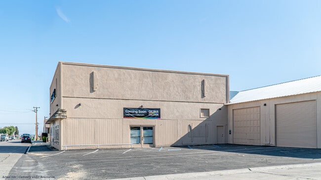
Property Record
315 Main St, Taft, CA 93268


Save to a Folder
{{folder.Name}}
{{folder.ListingIds.length}} Properties
{{folder.ListingIds.length}} Property
Create a New Folder
Property Detail
315 Main St
032-113-06-00-4
SECTION 13 , TOWNSHIP 32 , RANGE 23 , QUARTER SW
Autorepair
KERN
B and X Area of moderate flood hazard, usually the area between the limits of the 100-year and 500-year floods.
California
2025
0.75 AC
2025
SW Outlying Kern County
003500
Bakersfield
14,400 SF
Bakersfield-Delano, CA
NEARBY LISTINGS FOR SALE OR LEASE
DEMOGRAPHICS near 315 Main St
1 mile
3 mile
5 mile
2025 Total Population
11,419
16,984
17,050
2030 Population
11,729
17,459
17,526
Pop Growth 2025-2030
+ 2.71%
+ 2.80%
+ 2.79%
Average Age
34
34
34
2025 Total Households
3,721
5,404
5,424
HH Growth 2025-2030
+ 2.69%
+ 2.74%
+ 2.73%
Median Household Inc
$51,850
$53,743
$53,782
Avg Household Size
3.00
3.10
3.10
2025 Avg HH Vehicles
1.00
2.00
2.00
Median Home Value
$254,478
$247,189
$247,332
Median Year Built
1957
1958
1958
Nearby Places
Map Layers
Map Styles
 Street
 Aerial
Layers
 Traffic
 Biking
Places
Listings with unknown addresses are not visible on the map
- Restaurants
- Banks
- Shops
- Fitness
- Groceries
PUBLIC TRANSPORTATION
AIRPORT
Meadows Field
Drive
Walk
Distance
Meadows Field
62 min
39.4 mi
SALE & LEASE HISTORY
LISTING DATE
SALE/LEASE

Feb 19, 2025
For Sale
Nearby Properties
Address
Land Use
TOTAL SIZE
Lot Size
Zoning
Address
Land Use
TOTAL SIZE
Lot Size
Zoning
Address
Land Use
TOTAL SIZE
Lot Size
Zoning
59,514 SF
3.27 AC
C-1
Address
Land Use
TOTAL SIZE
Lot Size
Zoning
2.48 AC
MU
Address
Land Use
TOTAL SIZE
Lot Size
Zoning
35,719 SF
1.71 AC
MU
Address
Land Use
TOTAL SIZE
Lot Size
Zoning
19,664 SF
11.07 AC
M-2 PD AND
Address
Land Use
TOTAL SIZE
Lot Size
Zoning
43,041 SF
3.37 AC
GC
Address
Land Use
TOTAL SIZE
Lot Size
Zoning
2,930 SF
3.30 AC
Address
Land Use
TOTAL SIZE
Lot Size
Zoning
2,126 SF
9.56 AC
M1
Address
Land Use
TOTAL SIZE
Lot Size
Zoning
9,100 SF
1.06 AC
MU
Address
Land Use
TOTAL SIZE
Lot Size
Zoning
7,453 SF
0.60 AC
DC
Address
Land Use
TOTAL SIZE
Lot Size
Zoning
19,108 SF
1.58 AC
GC
Address
Land Use
TOTAL SIZE
Lot Size
Zoning
19,539 SF
1.42 AC
Address
Land Use
TOTAL SIZE
Lot Size
Zoning
8,000 SF
1.29 AC
C2
Address
Land Use
TOTAL SIZE
Lot Size
Zoning
6,505 SF
1.38 AC
C2
Address
Land Use
TOTAL SIZE
Lot Size
Zoning
40,150 SF
3.85 AC
C2PD
Address
Land Use
TOTAL SIZE
Lot Size
Zoning
1,368 SF
563.99 AC
A
Address
Land Use
TOTAL SIZE
Lot Size
Zoning
22,128 SF
1.58 AC
Address
Land Use
TOTAL SIZE
Lot Size
Zoning
12,629 SF
3.67 AC
I
Address
Land Use
TOTAL SIZE
Lot Size
Zoning
6,427 SF
0.47 AC
DC
Address
Land Use
TOTAL SIZE
Lot Size
Zoning
0.74 AC
Address
Land Use
TOTAL SIZE
Lot Size
Zoning
9,359 SF
1.50 AC
C2PD
Address
Land Use
TOTAL SIZE
Lot Size
Zoning
3,634 SF
1.07 AC
Address
Land Use
TOTAL SIZE
Lot Size
Zoning
220 SF
0.71 AC
GC
Address
Land Use
TOTAL SIZE
Lot Size
Zoning
435.08 AC
Address
Land Use
TOTAL SIZE
Lot Size
Zoning
5.30 AC
Address
Land Use
TOTAL SIZE
Lot Size
Zoning
14,499 SF
1.13 AC
The World's #1 Commercial Real Estate Marketplace
Connect with us
© 2026 CoStar Group
The information above has been obtained from sources believed reliable. While we do not doubt its accuracy we have not verified it and make no guarantee, warranty or representation about it. It is your responsibility to independently confirm its accuracy and completeness. Any projections, opinions, assumptions, or estimates used are for example only and do not represent the current or future performance of the property. The value of this transaction to you depends on tax and other factors which should be evaluated by your tax, financial, and legal advisors. You and your advisors should conduct a careful, independent investigation of the property to determine to your satisfaction the suitability of the property for your needs.