Property Record
315 N 3Rd St, Sanger, TX 76266
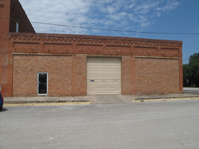

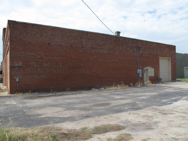
Property Detail
315 N 3Rd St
Dallas-Fort Worth-Arlington, TX
O T SANGER BLK 15 LOT 8,9,10(N90 OF EA),11(N90 OF E12.5)
R58798
Denton
Commercialnec
Texas
B and X Area of moderate flood hazard, usually the area between the limits of the 100-year and 500-year floods.
8,9
2024
0.18 AC
2025
Outlying Denton County
020203
Dallas/Ft Worth
4,720 SF
NEARBY LISTINGS FOR SALE OR LEASE
DEMOGRAPHICS near 315 N 3Rd St
1 mile
3 mile
5 mile
2025 Total Population
5,788
12,718
17,529
2030 Population
6,524
14,401
19,828
Pop Growth 2025-2030
+ 12.72%
+ 13.23%
+ 13.12%
Average Age
37
38
39
2025 Total Households
2,050
4,621
6,344
HH Growth 2025-2030
+ 12.98%
+ 13.53%
+ 13.40%
Median Household Inc
$96,650
$90,274
$93,736
Avg Household Size
2.80
2.70
2.70
2025 Avg HH Vehicles
2.00
2.00
2.00
Median Home Value
$315,857
$344,206
$367,403
Median Year Built
2000
2003
2002
Nearby Places
Map Layers
Map Styles
 Street
 Aerial
Layers
 Traffic
 Biking
Places
Listings with unknown addresses are not visible on the map
- Restaurants
- Banks
- Shops
- Fitness
- Groceries
PUBLIC TRANSPORTATION
AIRPORT
Dallas-Fort Worth International
Drive
Walk
Distance
Dallas-Fort Worth International
47 min
39.3 mi
Nearby Properties
Address
Land Use
TOTAL SIZE
Lot Size
Zoning
Address
Land Use
TOTAL SIZE
Lot Size
Zoning
1,146,032 SF
211.75 AC
Address
Land Use
TOTAL SIZE
Lot Size
Zoning
145,922 SF
19.20 AC
Address
Land Use
TOTAL SIZE
Lot Size
Zoning
194,560 SF
13.59 AC
Address
Land Use
TOTAL SIZE
Lot Size
Zoning
137,870 SF
79.72 AC
Address
Land Use
TOTAL SIZE
Lot Size
Zoning
143,892 SF
26.58 AC
Address
Land Use
TOTAL SIZE
Lot Size
Zoning
91,241 SF
23.51 AC
Address
Land Use
TOTAL SIZE
Lot Size
Zoning
71,787 SF
12.02 AC
Address
Land Use
TOTAL SIZE
Lot Size
Zoning
67,615 SF
19.22 AC
Address
Land Use
TOTAL SIZE
Lot Size
Zoning
81,684 SF
13.35 AC
Address
Land Use
TOTAL SIZE
Lot Size
Zoning
38.58 AC
Address
Land Use
TOTAL SIZE
Lot Size
Zoning
49,112 SF
2.03 AC
Address
Land Use
TOTAL SIZE
Lot Size
Zoning
1,153,213 SF
81.58 AC
Address
Land Use
TOTAL SIZE
Lot Size
Zoning
45.51 AC
Address
Land Use
TOTAL SIZE
Lot Size
Zoning
15.68 AC
Address
Land Use
TOTAL SIZE
Lot Size
Zoning
48,064 SF
4.34 AC
Address
Land Use
TOTAL SIZE
Lot Size
Zoning
23,958 SF
9.94 AC
Address
Land Use
TOTAL SIZE
Lot Size
Zoning
109,416 SF
10.77 AC
Address
Land Use
TOTAL SIZE
Lot Size
Zoning
1,116 SF
49.89 AC
Address
Land Use
TOTAL SIZE
Lot Size
Zoning
70,800 SF
Address
Land Use
TOTAL SIZE
Lot Size
Zoning
18,542 SF
1.67 AC
Address
Land Use
TOTAL SIZE
Lot Size
Zoning
36,012 SF
0.34 AC
Address
Land Use
TOTAL SIZE
Lot Size
Zoning
2,475 SF
112.83 AC
Address
Land Use
TOTAL SIZE
Lot Size
Zoning
3,050 SF
42.34 AC
Address
Land Use
TOTAL SIZE
Lot Size
Zoning
5,930 SF
8.17 AC
Address
Land Use
TOTAL SIZE
Lot Size
Zoning
5,281 SF
1.75 AC
Address
Land Use
TOTAL SIZE
Lot Size
Zoning
8,011 SF
247.32 AC
Address
Land Use
TOTAL SIZE
Lot Size
Zoning
23,560 SF
2 AC
Address
Land Use
TOTAL SIZE
Lot Size
Zoning
20.98 AC
Address
Land Use
TOTAL SIZE
Lot Size
Zoning
20.09 AC
The World's #1 Commercial Real Estate Marketplace
Connect with us
© 2026 CoStar Group
The information above has been obtained from sources believed reliable. While we do not doubt its accuracy we have not verified it and make no guarantee, warranty or representation about it. It is your responsibility to independently confirm its accuracy and completeness. Any projections, opinions, assumptions, or estimates used are for example only and do not represent the current or future performance of the property. The value of this transaction to you depends on tax and other factors which should be evaluated by your tax, financial, and legal advisors. You and your advisors should conduct a careful, independent investigation of the property to determine to your satisfaction the suitability of the property for your needs.