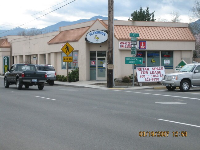
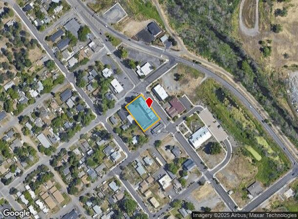
Property Record
315 N Main St, Phoenix, OR 97535

NEARBY LISTINGS FOR SALE OR LEASE
-
-
No Photo
-
View all Phoenix listings for sale on LoopNet.com
Property Detail
315 N Main St
10010590
City Of Phoenix
Commercialbuilding
Jackson
X
Oregon
41029C1989F
2-4
2024
0.50 AC
2025
Medford/Grants Pass
001602
Other Market Areas
4,560 SF
Medford, OR
DEMOGRAPHICS near 315 N Main St
1 Mile
3 Mile
5 Mile
2024 Total Population
6,049
20,658
70,547
2029 Population
5,932
20,474
70,109
Pop Growth 2024-2029
(1.93%)
(0.89%)
(0.62%)
Average Age
44
46
43
2024 Total Households
2,678
9,413
29,189
HH Growth 2024-2029
(2.24%)
(1.01%)
(0.71%)
Median Household Inc
$41,130
$50,971
$60,381
Avg Household Size
2.20
2.10
2.30
2024 Avg HH Vehicles
2.00
2.00
2.00
Median Home Value
$236,802
$334,544
$370,874
Median Year Built
1978
1988
1980
Nearby Places
Map Layers
Map Styles
 Street
 Aerial
- Restaurants
- Banks
- Shops
- Fitness
- Groceries
PUBLIC TRANSPORTATION
AIRPORT
Rogue Valley International - Medford
DRIVE
WALK
Distance
Rogue Valley International - Medford
15 min
8.5 mi
Nearby Properties
Address
Land Use
TOTAL SIZE
Lot Size
Zoning
Address
Land Use
TOTAL SIZE
Lot Size
Zoning
674,760 SF
104.26 AC
SFR-4
Address
Land Use
TOTAL SIZE
Lot Size
Zoning
762,720 SF
16.25 AC
C-S/P
Address
Land Use
TOTAL SIZE
Lot Size
Zoning
Address
Land Use
TOTAL SIZE
Lot Size
Zoning
30.50 AC
SFR-4
Address
Land Use
TOTAL SIZE
Lot Size
Zoning
11,850 SF
3.19 AC
RS-7
Address
Land Use
TOTAL SIZE
Lot Size
Zoning
81.70 AC
LI
Address
Land Use
TOTAL SIZE
Lot Size
Zoning
31,338 SF
4.41 AC
C-R
Address
Land Use
TOTAL SIZE
Lot Size
Zoning
212,477 SF
13.74 AC
I-L
Address
Land Use
TOTAL SIZE
Lot Size
Zoning
5.22 AC
MFR-30
Address
Land Use
TOTAL SIZE
Lot Size
Zoning
12.55 AC
RM-22
Address
Land Use
TOTAL SIZE
Lot Size
Zoning
9,216 SF
1.66 AC
C-R
Address
Land Use
TOTAL SIZE
Lot Size
Zoning
12,944 SF
21.34 AC
SFR-4
Address
Land Use
TOTAL SIZE
Lot Size
Zoning
92,000 SF
3.39 AC
MFR-30
Address
Land Use
TOTAL SIZE
Lot Size
Zoning
130,599 SF
9.43 AC
C-H
Address
Land Use
TOTAL SIZE
Lot Size
Zoning
50,943 SF
0.18 AC
SFR-00
Address
Land Use
TOTAL SIZE
Lot Size
Zoning
37,997 SF
14.47 AC
SFR-4
Address
Land Use
TOTAL SIZE
Lot Size
Zoning
81.69 AC
LI
Address
Land Use
TOTAL SIZE
Lot Size
Zoning
1,543 SF
3.51 AC
RS-MH
Address
Land Use
TOTAL SIZE
Lot Size
Zoning
1,660 SF
4.65 AC
C-H
Address
Land Use
TOTAL SIZE
Lot Size
Zoning
22,504 SF
1.88 AC
C-S/P
Address
Land Use
TOTAL SIZE
Lot Size
Zoning
5.46 AC
RS-7
Address
Land Use
TOTAL SIZE
Lot Size
Zoning
9,052 SF
6.42 AC
SFR-00
Address
Land Use
TOTAL SIZE
Lot Size
Zoning
13,416 SF
1.64 AC
MFR-20
Address
Land Use
TOTAL SIZE
Lot Size
Zoning
71,475 SF
6.18 AC
C-H
Address
Land Use
TOTAL SIZE
Lot Size
Zoning
35,848 SF
1.80 AC
SFR-6
Address
Land Use
TOTAL SIZE
Lot Size
Zoning
18,611 SF
1.54 AC
C-C
Address
Land Use
TOTAL SIZE
Lot Size
Zoning
88,951 SF
3.42 AC
C-R
Address
Land Use
TOTAL SIZE
Lot Size
Zoning
3,716 SF
1.72 AC
GC
Address
Land Use
TOTAL SIZE
Lot Size
Zoning
64,250 SF
8.13 AC
UR-30
Address
Land Use
TOTAL SIZE
Lot Size
Zoning
1 AC
RR-5
The World's #1 Commercial Real Estate Marketplace
Connect with us
© 2025 CoStar Group
The information above has been obtained from sources believed reliable. While we do not doubt its accuracy we have not verified it and make no guarantee, warranty or representation about it. It is your responsibility to independently confirm its accuracy and completeness. Any projections, opinions, assumptions, or estimates used are for example only and do not represent the current or future performance of the property. The value of this transaction to you depends on tax and other factors which should be evaluated by your tax, financial, and legal advisors. You and your advisors should conduct a careful, independent investigation of the property to determine to your satisfaction the suitability of the property for your needs.