Property Record
315 S 2Nd St, Cedartown, GA 30125
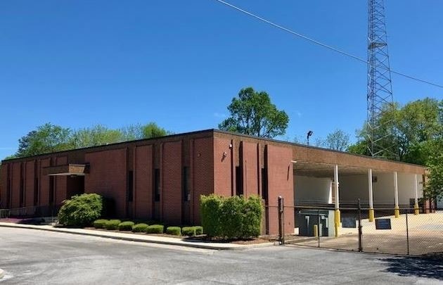

Property Detail
315 S 2Nd St
024B033-
LL 849
Officebuilding
Polk
C and X Area of minimal flood hazard, usually depicted on FIRMs as above the 500-year flood level.
Georgia
2025
2.10 AC
2025
Georgia Northwest
010400
Other Market Areas
6,976 SF
Cedartown, GA
NEARBY LISTINGS FOR SALE OR LEASE
DEMOGRAPHICS near 315 S 2Nd St
1 mile
3 mile
5 mile
2025 Total Population
4,983
16,667
21,066
2030 Population
5,160
17,237
21,764
Pop Growth 2025-2030
+ 3.55%
+ 3.42%
+ 3.31%
Average Age
36
38
39
2025 Total Households
1,693
6,027
7,726
HH Growth 2025-2030
+ 3.54%
+ 3.33%
+ 3.24%
Median Household Inc
$38,102
$47,969
$53,514
Avg Household Size
2.80
2.70
2.60
2025 Avg HH Vehicles
2.00
2.00
2.00
Median Home Value
$136,738
$160,532
$168,100
Median Year Built
1968
1977
1979
Nearby Places
Map Layers
Map Styles
 Street
 Aerial
Layers
 Traffic
 Biking
Places
Listings with unknown addresses are not visible on the map
- Restaurants
- Banks
- Shops
- Fitness
- Groceries
SALE & LEASE HISTORY
LISTING DATE
SALE/LEASE

Sep 27, 2019
For Sale
Sep 24, 2019
For Sale
Mar 21, 2024
For Sale
Nearby Properties
Address
Land Use
TOTAL SIZE
Lot Size
Zoning
Address
Land Use
TOTAL SIZE
Lot Size
Zoning
13,476 SF
84.78 AC
Address
Land Use
TOTAL SIZE
Lot Size
Zoning
563,570 SF
44.28 AC
Address
Land Use
TOTAL SIZE
Lot Size
Zoning
58,890 SF
6.76 AC
Address
Land Use
TOTAL SIZE
Lot Size
Zoning
47,050 SF
349.53 AC
Address
Land Use
TOTAL SIZE
Lot Size
Zoning
13,476 SF
25 AC
Address
Land Use
TOTAL SIZE
Lot Size
Zoning
1,632 SF
10.40 AC
Address
Land Use
TOTAL SIZE
Lot Size
Zoning
85,418 SF
2.19 AC
Address
Land Use
TOTAL SIZE
Lot Size
Zoning
46,538 SF
3.50 AC
Address
Land Use
TOTAL SIZE
Lot Size
Zoning
30,741 SF
5.39 AC
Address
Land Use
TOTAL SIZE
Lot Size
Zoning
41,764 SF
109.40 AC
Address
Land Use
TOTAL SIZE
Lot Size
Zoning
49,122 SF
3.54 AC
Address
Land Use
TOTAL SIZE
Lot Size
Zoning
26,440 SF
10 AC
Address
Land Use
TOTAL SIZE
Lot Size
Zoning
4,200 SF
10.14 AC
Address
Land Use
TOTAL SIZE
Lot Size
Zoning
18,678 SF
12.92 AC
Address
Land Use
TOTAL SIZE
Lot Size
Zoning
40,610 SF
3.56 AC
Address
Land Use
TOTAL SIZE
Lot Size
Zoning
82,750 SF
6.91 AC
Address
Land Use
TOTAL SIZE
Lot Size
Zoning
33,500 SF
1.60 AC
Address
Land Use
TOTAL SIZE
Lot Size
Zoning
45,000 SF
10 AC
Address
Land Use
TOTAL SIZE
Lot Size
Zoning
18,830 SF
3.91 AC
Address
Land Use
TOTAL SIZE
Lot Size
Zoning
27,715 SF
0.96 AC
Address
Land Use
TOTAL SIZE
Lot Size
Zoning
14,640 SF
8.81 AC
Address
Land Use
TOTAL SIZE
Lot Size
Zoning
31,164 SF
13.09 AC
Address
Land Use
TOTAL SIZE
Lot Size
Zoning
8,400 SF
5.32 AC
Address
Land Use
TOTAL SIZE
Lot Size
Zoning
6,210 SF
6.07 AC
Address
Land Use
TOTAL SIZE
Lot Size
Zoning
33,328 SF
2.28 AC
Address
Land Use
TOTAL SIZE
Lot Size
Zoning
1,404 SF
8.58 AC
Address
Land Use
TOTAL SIZE
Lot Size
Zoning
23,390 SF
6.79 AC
Address
Land Use
TOTAL SIZE
Lot Size
Zoning
20,528 SF
4.41 AC
Address
Land Use
TOTAL SIZE
Lot Size
Zoning
12,634 SF
2.70 AC
Address
Land Use
TOTAL SIZE
Lot Size
Zoning
3,648 SF
91.48 AC
The World's #1 Commercial Real Estate Marketplace
Connect with us
© 2026 CoStar Group
The information above has been obtained from sources believed reliable. While we do not doubt its accuracy we have not verified it and make no guarantee, warranty or representation about it. It is your responsibility to independently confirm its accuracy and completeness. Any projections, opinions, assumptions, or estimates used are for example only and do not represent the current or future performance of the property. The value of this transaction to you depends on tax and other factors which should be evaluated by your tax, financial, and legal advisors. You and your advisors should conduct a careful, independent investigation of the property to determine to your satisfaction the suitability of the property for your needs.