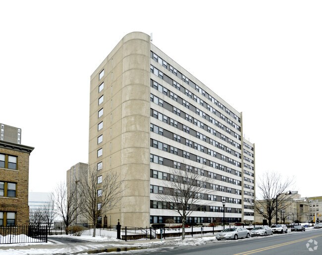
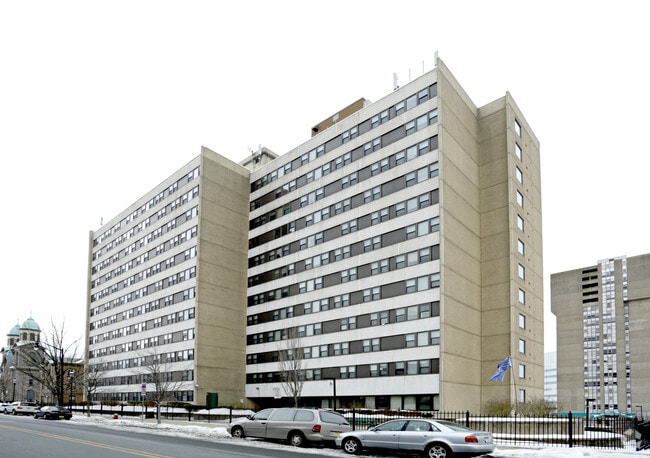
Property Record
315 S Broad St, Trenton, NJ 08608
NEARBY LISTINGS FOR SALE OR LEASE
Property Detail
315 S Broad St
Trenton, NJ
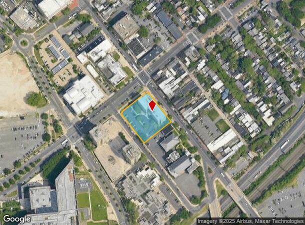
Alta Acsm Land Title Survey
11-09901-0000-00003
FACILITY NAME: PUBLIC HOUSING
Taxexempt
Mercer
X
New Jersey
34021C0209F
3
0
1.08 AC
2025
Downtown Trenton
000900
Northern New Jersey
116,766 SF
DEMOGRAPHICS near 315 S Broad St
1 Mile
3 Mile
5 Mile
2024 Total Population
32,286
148,165
255,000
2029 Population
31,706
146,183
252,110
Pop Growth 2024-2029
(1.80%)
(1.34%)
(1.13%)
Average Age
36
37
40
2024 Total Households
11,208
52,342
94,264
HH Growth 2024-2029
(1.71%)
(1.36%)
(1.19%)
Median Household Inc
$40,578
$57,603
$73,773
Avg Household Size
2.70
2.70
2.60
2024 Avg HH Vehicles
1.00
1.00
2.00
Median Home Value
$89,025
$168,337
$249,959
Median Year Built
1947
1949
1956
Nearby Places
Map Layers
Map Styles
 Street
 Aerial
- Restaurants
- Banks
- Shops
- Fitness
- Groceries
PUBLIC TRANSPORTATION
TRANSIT/SUBWAY
Trenton (River LINE - NJ TRANSIT RAIL, Riverline Light Rail - NJ TRANSIT RAIL)
DRIVE
WALK
Distance
Trenton (River LINE - NJ TRANSIT RAIL, Riverline Light Rail - NJ TRANSIT RAIL)
1 min
10 min
0.5 mi
Hamilton Avenue (River LINE - River LINE (River LINE))
DRIVE
WALK
Distance
Hamilton Avenue (River LINE - River LINE (River LINE))
2 min
11 min
0.6 mi
Cass Street (River LINE - River LINE (River LINE))
DRIVE
WALK
Distance
Cass Street (River LINE - River LINE (River LINE))
5 min
17 min
0.9 mi
COMMUTER RAIL
Trenton Transit Center (Trenton Line - SEPTA)
DRIVE
WALK
Distance
Trenton Transit Center (Trenton Line - SEPTA)
1 min
10 min
0.5 mi
Trenton Transit Center (Njt) (Northeast Corridor Line - NJ Transit Commuter Rail (NJ Transit), R7 - NJ Transit Commuter Rail (NJ Transit), River LINE - NJ Transit Commuter Rail (NJ Transit))
DRIVE
WALK
Distance
Trenton Transit Center (Njt) (Northeast Corridor Line - NJ Transit Commuter Rail (NJ Transit), R7 - NJ Transit Commuter Rail (NJ Transit), River LINE - NJ Transit Commuter Rail (NJ Transit))
4 min
11 min
0.6 mi
AIRPORT
Trenton Mercer
DRIVE
WALK
Distance
Trenton Mercer
12 min
6.1 mi
Freight Ports
Port of Philadelphia
DRIVE
WALK
Distance
Port of Philadelphia
42 min
28.8 mi
Nearby Properties
Address
Land Use
TOTAL SIZE
Lot Size
Zoning
Address
Land Use
TOTAL SIZE
Lot Size
Zoning
8.23 AC
BA
Address
Land Use
TOTAL SIZE
Lot Size
Zoning
26 AC
HIST
Address
Land Use
TOTAL SIZE
Lot Size
Zoning
6.69 AC
BA
Address
Land Use
TOTAL SIZE
Lot Size
Zoning
13.73 AC
Address
Land Use
TOTAL SIZE
Lot Size
Zoning
Address
Land Use
TOTAL SIZE
Lot Size
Zoning
1,996 SF
125 AC
RA
Address
Land Use
TOTAL SIZE
Lot Size
Zoning
879,376 SF
2.54 AC
BA
Address
Land Use
TOTAL SIZE
Lot Size
Zoning
43,715 SF
49.95 AC
Address
Land Use
TOTAL SIZE
Lot Size
Zoning
125,000 SF
3.68 AC
MU
Address
Land Use
TOTAL SIZE
Lot Size
Zoning
104,448 SF
8.49 AC
IA
Address
Land Use
TOTAL SIZE
Lot Size
Zoning
5.38 AC
MU
Address
Land Use
TOTAL SIZE
Lot Size
Zoning
288,000 SF
1.23 AC
BA
Address
Land Use
TOTAL SIZE
Lot Size
Zoning
35.83 AC
RB
Address
Land Use
TOTAL SIZE
Lot Size
Zoning
0.24 AC
BA
Address
Land Use
TOTAL SIZE
Lot Size
Zoning
186,960 SF
2.37 AC
BA
Address
Land Use
TOTAL SIZE
Lot Size
Zoning
212,074 SF
0.82 AC
BA
Address
Land Use
TOTAL SIZE
Lot Size
Zoning
13.85 AC
MU
Address
Land Use
TOTAL SIZE
Lot Size
Zoning
323,087 SF
1.95 AC
PM
Address
Land Use
TOTAL SIZE
Lot Size
Zoning
161,080 SF
2.21 AC
BA
Address
Land Use
TOTAL SIZE
Lot Size
Zoning
21.19 AC
B-H
Address
Land Use
TOTAL SIZE
Lot Size
Zoning
64.33 AC
R-2
Address
Land Use
TOTAL SIZE
Lot Size
Zoning
10.29 AC
RB
Address
Land Use
TOTAL SIZE
Lot Size
Zoning
41,000 SF
0.91 AC
HIST
Address
Land Use
TOTAL SIZE
Lot Size
Zoning
8.46 AC
RA
Address
Land Use
TOTAL SIZE
Lot Size
Zoning
158,000 SF
2.06 AC
BA
Address
Land Use
TOTAL SIZE
Lot Size
Zoning
4.07 AC
MU
Address
Land Use
TOTAL SIZE
Lot Size
Zoning
357 SF
0.96 AC
HIST
Address
Land Use
TOTAL SIZE
Lot Size
Zoning
260,160 SF
0.84 AC
BA
Address
Land Use
TOTAL SIZE
Lot Size
Zoning
161,520 SF
0.77 AC
BA
Address
Land Use
TOTAL SIZE
Lot Size
Zoning
16.86 AC
EG1
The World's #1 Commercial Real Estate Marketplace
Connect with us
© 2025 CoStar Group
The information above has been obtained from sources believed reliable. While we do not doubt its accuracy we have not verified it and make no guarantee, warranty or representation about it. It is your responsibility to independently confirm its accuracy and completeness. Any projections, opinions, assumptions, or estimates used are for example only and do not represent the current or future performance of the property. The value of this transaction to you depends on tax and other factors which should be evaluated by your tax, financial, and legal advisors. You and your advisors should conduct a careful, independent investigation of the property to determine to your satisfaction the suitability of the property for your needs.