Property Record
315 S Main St, Iola, KS 66749
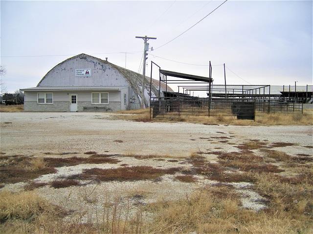

Property Detail
315 S Main St
089-32-0-10-01-007.00-0
S32, T24, R19, ACRES 22.6, BEG 375' W & 600' S NE COR NE4, S 720', W 1479.69', N 620', E 581', N 100', E 870' TO POB
Warehouse
ALLEN
B and X Area of moderate flood hazard, usually the area between the limits of the 100-year and 500-year floods.
Kansas
2024
22.60 AC
2025
Kansas Area
952800
Other Market Areas
11,880 SF
NEARBY LISTINGS FOR SALE OR LEASE
-
-
View all Iola listings for sale on LoopNet.com
DEMOGRAPHICS near 315 S Main St
1 mile
3 mile
5 mile
2025 Total Population
387
3,353
7,681
2030 Population
348
3,284
7,620
Pop Growth 2025-2030
(10.08%)
(2.06%)
(0.79%)
Average Age
43
42
41
2025 Total Households
152
1,390
3,225
HH Growth 2025-2030
(9.87%)
(1.94%)
(0.71%)
Median Household Inc
$61,765
$51,850
$52,788
Avg Household Size
2.30
2.30
2.20
2025 Avg HH Vehicles
3.00
2.00
2.00
Median Home Value
$141,346
$97,435
$98,105
Median Year Built
1973
1972
1967
Nearby Places
Map Layers
Map Styles
 Street
 Aerial
Layers
 Traffic
 Biking
Places
Listings with unknown addresses are not visible on the map
- Restaurants
- Banks
- Shops
- Fitness
- Groceries
SALE & LEASE HISTORY
LISTING DATE
SALE/LEASE

Jun 03, 2021
For Sale
Nearby Properties
Address
Land Use
TOTAL SIZE
Lot Size
Zoning
Address
Land Use
TOTAL SIZE
Lot Size
Zoning
1,920 SF
15.70 AC
Address
Land Use
TOTAL SIZE
Lot Size
Zoning
14,433 SF
1.90 AC
Address
Land Use
TOTAL SIZE
Lot Size
Zoning
7,912 SF
2.50 AC
Address
Land Use
TOTAL SIZE
Lot Size
Zoning
3,624 SF
0.70 AC
Address
Land Use
TOTAL SIZE
Lot Size
Zoning
20,570 SF
2.83 AC
Address
Land Use
TOTAL SIZE
Lot Size
Zoning
12,800 SF
0.92 AC
Address
Land Use
TOTAL SIZE
Lot Size
Zoning
17,259 SF
1.60 AC
Address
Land Use
TOTAL SIZE
Lot Size
Zoning
8,200 SF
1.81 AC
Address
Land Use
TOTAL SIZE
Lot Size
Zoning
27,108 SF
2.62 AC
Address
Land Use
TOTAL SIZE
Lot Size
Zoning
18,920 SF
2 AC
Address
Land Use
TOTAL SIZE
Lot Size
Zoning
8,700 SF
5.40 AC
Address
Land Use
TOTAL SIZE
Lot Size
Zoning
3,920 SF
1.20 AC
Address
Land Use
TOTAL SIZE
Lot Size
Zoning
8,784 SF
0.41 AC
Address
Land Use
TOTAL SIZE
Lot Size
Zoning
5,329 SF
1.50 AC
Address
Land Use
TOTAL SIZE
Lot Size
Zoning
7,225 SF
0.74 AC
Address
Land Use
TOTAL SIZE
Lot Size
Zoning
5,040 SF
4.05 AC
Address
Land Use
TOTAL SIZE
Lot Size
Zoning
8,700 SF
3.10 AC
Address
Land Use
TOTAL SIZE
Lot Size
Zoning
2.40 AC
Address
Land Use
TOTAL SIZE
Lot Size
Zoning
0.35 AC
Address
Land Use
TOTAL SIZE
Lot Size
Zoning
4,568 SF
1.06 AC
Address
Land Use
TOTAL SIZE
Lot Size
Zoning
11,096 SF
0.32 AC
Address
Land Use
TOTAL SIZE
Lot Size
Zoning
12,000 SF
3 AC
Address
Land Use
TOTAL SIZE
Lot Size
Zoning
1,560 SF
0.72 AC
Address
Land Use
TOTAL SIZE
Lot Size
Zoning
5,000 SF
2.48 AC
Address
Land Use
TOTAL SIZE
Lot Size
Zoning
6,400 SF
10 AC
Address
Land Use
TOTAL SIZE
Lot Size
Zoning
9,796 SF
0.68 AC
Address
Land Use
TOTAL SIZE
Lot Size
Zoning
4,250 SF
4 AC
Address
Land Use
TOTAL SIZE
Lot Size
Zoning
3,200 SF
1.24 AC
Address
Land Use
TOTAL SIZE
Lot Size
Zoning
20,000 SF
1 AC
Address
Land Use
TOTAL SIZE
Lot Size
Zoning
50.30 AC
The World's #1 Commercial Real Estate Marketplace
Connect with us
© 2026 CoStar Group
The information above has been obtained from sources believed reliable. While we do not doubt its accuracy we have not verified it and make no guarantee, warranty or representation about it. It is your responsibility to independently confirm its accuracy and completeness. Any projections, opinions, assumptions, or estimates used are for example only and do not represent the current or future performance of the property. The value of this transaction to you depends on tax and other factors which should be evaluated by your tax, financial, and legal advisors. You and your advisors should conduct a careful, independent investigation of the property to determine to your satisfaction the suitability of the property for your needs.