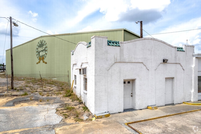
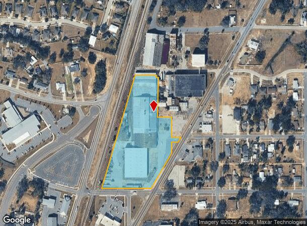
Property Record
315 Us Highway 17 92 N, Davenport, FL 33837

Current Lease Availabilities
NEARBY LISTINGS FOR SALE OR LEASE
Property Detail
315 Us Highway 17 92 N
27-27-03-720500-001010
Holly Hill Fruit Products Inc Replat
Cannery
REPLAT OF HOLLY HILL FRUIT PRODUCTS COMPANY PB 28 PG 2 BLK 6A LESS BEG NE COR RUN W 88.55 FT S 142.17 FT W 3.4 FT S 130.81 FT E 97.83 FT N TO POB & LESS ST HWY & S1/2 OF CLOSED PINE ST E OF ABOVE EXTENDING TO HWY & S 15 FT OF CLOSED NORTH BLVD EXTEND
X
Polk
12105C0240G
Florida
2024
5.55 AC
2025
Polk County
012508
Tampa/St Petersburg
112,351 SF
Lakeland-Winter Haven, FL
DEMOGRAPHICS near 315 Us Highway 17 92 N
1 Mile
3 Mile
5 Mile
2024 Total Population
8,249
44,316
93,288
2029 Population
10,348
55,453
115,954
Pop Growth 2024-2029
+ 25.45%
+ 25.13%
+ 24.30%
Average Age
40
40
40
2024 Total Households
2,806
15,386
32,522
HH Growth 2024-2029
+ 25.37%
+ 25.10%
+ 24.36%
Median Household Inc
$59,316
$65,512
$58,176
Avg Household Size
2.80
2.80
2.80
2024 Avg HH Vehicles
2.00
2.00
2.00
Median Home Value
$264,656
$256,910
$239,167
Median Year Built
2010
2010
2008
Nearby Places
Map Layers
Map Styles
 Street
 Aerial
- Restaurants
- Banks
- Shops
- Fitness
- Groceries
PUBLIC TRANSPORTATION
AIRPORT
Orlando International
DRIVE
WALK
Distance
Orlando International
50 min
35.4 mi
Nearby Properties
Address
Land Use
TOTAL SIZE
Lot Size
Zoning
Address
Land Use
TOTAL SIZE
Lot Size
Zoning
306,788 SF
13.35 AC
XX
Address
Land Use
TOTAL SIZE
Lot Size
Zoning
310,669 SF
36.01 AC
RC
Address
Land Use
TOTAL SIZE
Lot Size
Zoning
132,578 SF
0.31 AC
Address
Land Use
TOTAL SIZE
Lot Size
Zoning
60,240 SF
9.21 AC
RC
Address
Land Use
TOTAL SIZE
Lot Size
Zoning
46,800 SF
3.28 AC
Address
Land Use
TOTAL SIZE
Lot Size
Zoning
146,350 SF
19.49 AC
Address
Land Use
TOTAL SIZE
Lot Size
Zoning
65,340 SF
18.65 AC
RC
Address
Land Use
TOTAL SIZE
Lot Size
Zoning
128,885 SF
8.39 AC
Address
Land Use
TOTAL SIZE
Lot Size
Zoning
35,772 SF
14.75 AC
RC
Address
Land Use
TOTAL SIZE
Lot Size
Zoning
84,480 SF
4.68 AC
RC
Address
Land Use
TOTAL SIZE
Lot Size
Zoning
14,684 SF
2.26 AC
Address
Land Use
TOTAL SIZE
Lot Size
Zoning
22,896 SF
0.65 AC
Address
Land Use
TOTAL SIZE
Lot Size
Zoning
22,896 SF
0.56 AC
Address
Land Use
TOTAL SIZE
Lot Size
Zoning
21,199 SF
2.16 AC
Address
Land Use
TOTAL SIZE
Lot Size
Zoning
16,993 SF
26.11 AC
Address
Land Use
TOTAL SIZE
Lot Size
Zoning
16,186 SF
2.41 AC
Address
Land Use
TOTAL SIZE
Lot Size
Zoning
14,849 SF
1.90 AC
Address
Land Use
TOTAL SIZE
Lot Size
Zoning
67.70 AC
RC
Address
Land Use
TOTAL SIZE
Lot Size
Zoning
13,452 SF
1.75 AC
Address
Land Use
TOTAL SIZE
Lot Size
Zoning
8,698 SF
0.31 AC
Address
Land Use
TOTAL SIZE
Lot Size
Zoning
29,830 SF
22.30 AC
RC
Address
Land Use
TOTAL SIZE
Lot Size
Zoning
16,038 SF
0.39 AC
Address
Land Use
TOTAL SIZE
Lot Size
Zoning
81,412 SF
4.93 AC
RC
Address
Land Use
TOTAL SIZE
Lot Size
Zoning
21,981 SF
6.08 AC
Address
Land Use
TOTAL SIZE
Lot Size
Zoning
14,466 SF
9.57 AC
RC
Address
Land Use
TOTAL SIZE
Lot Size
Zoning
42,100 SF
4.11 AC
Address
Land Use
TOTAL SIZE
Lot Size
Zoning
47,278 SF
23.78 AC
C3
Address
Land Use
TOTAL SIZE
Lot Size
Zoning
31,316 SF
16.19 AC
XX
Address
Land Use
TOTAL SIZE
Lot Size
Zoning
7,150 SF
2.03 AC
Address
Land Use
TOTAL SIZE
Lot Size
Zoning
6,876 SF
2.81 AC
The World's #1 Commercial Real Estate Marketplace
Connect with us
© 2025 CoStar Group
The information above has been obtained from sources believed reliable. While we do not doubt its accuracy we have not verified it and make no guarantee, warranty or representation about it. It is your responsibility to independently confirm its accuracy and completeness. Any projections, opinions, assumptions, or estimates used are for example only and do not represent the current or future performance of the property. The value of this transaction to you depends on tax and other factors which should be evaluated by your tax, financial, and legal advisors. You and your advisors should conduct a careful, independent investigation of the property to determine to your satisfaction the suitability of the property for your needs.