Property Record
315 W 10Th St Ne, Rome, GA 30165
This Property Is For Sale
NEARBY LISTINGS FOR SALE OR LEASE
Property Detail
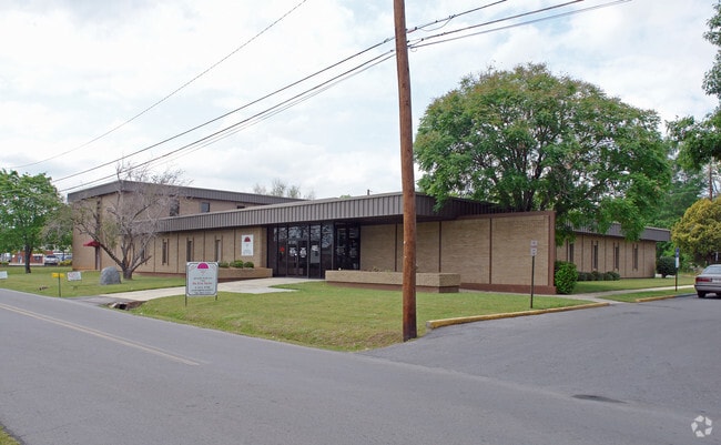
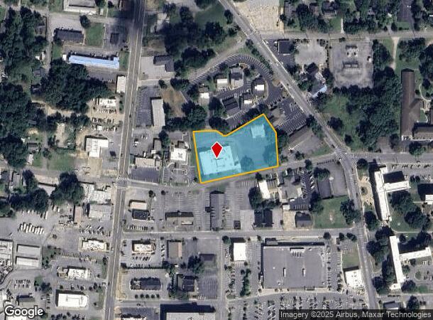
315 W 10Th St Ne
J13Y-389
FLOYD COUNTY HEALTH DEPT
Medicalbuilding
Floyd
X
Georgia
13115C0193E
1.78 AC
2024
Georgia Northwest
2024
Other Market Areas
001100
Rome, GA
18,472 SF
DEMOGRAPHICS near 315 W 10Th St Ne
1 Mile
3 Mile
5 Mile
2024 Total Population
4,203
33,268
62,269
2029 Population
4,374
34,257
63,834
Pop Growth 2024-2029
+ 4.07%
+ 2.97%
+ 2.51%
Average Age
40
37
38
2024 Total Households
1,882
12,165
23,083
HH Growth 2024-2029
+ 4.36%
+ 3.21%
+ 2.63%
Median Household Inc
$36,840
$48,454
$56,970
Avg Household Size
2.00
2.40
2.50
2024 Avg HH Vehicles
1.00
2.00
2.00
Median Home Value
$242,307
$178,479
$175,962
Median Year Built
1956
1966
1973
Nearby Places
- Restaurants
- Banks
- Shops
- Fitness
- Groceries
Nearby Properties
Address
Land Use
TOTAL SIZE
Lot Size
Zoning
Address
Land Use
TOTAL SIZE
Lot Size
Zoning
136,498 SF
9.23 AC
O-I
Address
Land Use
TOTAL SIZE
Lot Size
Zoning
1 SF
767.46 AC
O-I
Address
Land Use
TOTAL SIZE
Lot Size
Zoning
18.34 AC
O-I
Address
Land Use
TOTAL SIZE
Lot Size
Zoning
108,547 SF
1.54 AC
U-M-U
Address
Land Use
TOTAL SIZE
Lot Size
Zoning
20,532 SF
16.56 AC
C-C
Address
Land Use
TOTAL SIZE
Lot Size
Zoning
4,394 SF
14.26 AC
Address
Land Use
TOTAL SIZE
Lot Size
Zoning
30,991 SF
8.94 AC
Address
Land Use
TOTAL SIZE
Lot Size
Zoning
141,680 SF
6.27 AC
U-M-U
Address
Land Use
TOTAL SIZE
Lot Size
Zoning
57.50 AC
O-I
Address
Land Use
TOTAL SIZE
Lot Size
Zoning
54,817 SF
8.82 AC
C-C
Address
Land Use
TOTAL SIZE
Lot Size
Zoning
83,971 SF
0.29 AC
Address
Land Use
TOTAL SIZE
Lot Size
Zoning
75,156 SF
7.10 AC
O-I
Address
Land Use
TOTAL SIZE
Lot Size
Zoning
3,416 SF
13.87 AC
C-C
Address
Land Use
TOTAL SIZE
Lot Size
Zoning
52,321 SF
Address
Land Use
TOTAL SIZE
Lot Size
Zoning
47,541 SF
5.24 AC
O-I
Address
Land Use
TOTAL SIZE
Lot Size
Zoning
137,726 SF
12.51 AC
C-C
Address
Land Use
TOTAL SIZE
Lot Size
Zoning
59,796 SF
Address
Land Use
TOTAL SIZE
Lot Size
Zoning
30,267 SF
7.20 AC
C-C
Address
Land Use
TOTAL SIZE
Lot Size
Zoning
59,082 SF
8 AC
C-C
Address
Land Use
TOTAL SIZE
Lot Size
Zoning
19.64 AC
Address
Land Use
TOTAL SIZE
Lot Size
Zoning
84,460 SF
6.83 AC
C-C
Address
Land Use
TOTAL SIZE
Lot Size
Zoning
89,250 SF
7.05 AC
C-C
Address
Land Use
TOTAL SIZE
Lot Size
Zoning
42,440 SF
4.30 AC
C-C
Address
Land Use
TOTAL SIZE
Lot Size
Zoning
313,467 SF
0.13 AC
H-I
Address
Land Use
TOTAL SIZE
Lot Size
Zoning
26.30 AC
H-I
Address
Land Use
TOTAL SIZE
Lot Size
Zoning
11.84 AC
Address
Land Use
TOTAL SIZE
Lot Size
Zoning
36,301 SF
11.57 AC
O-I
Address
Land Use
TOTAL SIZE
Lot Size
Zoning
61,577 SF
1.31 AC
C-C
Address
Land Use
TOTAL SIZE
Lot Size
Zoning
6.35 AC
M-R
Address
Land Use
TOTAL SIZE
Lot Size
Zoning
2.62 AC
C-B-C
The World's #1 Commercial Real Estate Marketplace
Connect with us
© 2025 CoStar Group
The information above has been obtained from sources believed reliable. While we do not doubt its accuracy we have not verified it and make no guarantee, warranty or representation about it. It is your responsibility to independently confirm its accuracy and completeness. Any projections, opinions, assumptions, or estimates used are for example only and do not represent the current or future performance of the property. The value of this transaction to you depends on tax and other factors which should be evaluated by your tax, financial, and legal advisors. You and your advisors should conduct a careful, independent investigation of the property to determine to your satisfaction the suitability of the property for your needs.