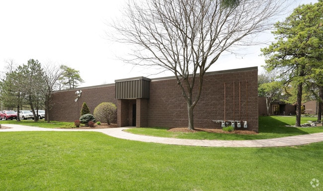
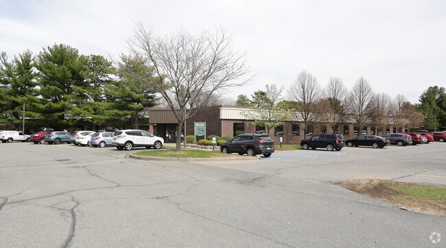
Property Record
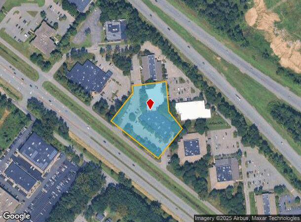
315 Washington Avenue Ext, Albany, NY 12205
NEARBY LISTINGS FOR SALE OR LEASE
Property Detail
315 Washington Avenue Ext
010100-041-000-0002-090-000-0000
Albany
Officebuilding
New York
X
90.000
36001C0178D
2.41 AC
2025
W Outer Albany County
2024
Albany/Schenectady/Troy
013902
Albany-Schenectady-Troy, NY
13,035 SF
DEMOGRAPHICS near 315 Washington Avenue Ext
1 Mile
3 Mile
5 Mile
2024 Total Population
2,617
46,879
120,682
2029 Population
2,632
46,740
120,323
Pop Growth 2024-2029
+ 0.57%
(0.30%)
(0.30%)
Average Age
56
40
42
2024 Total Households
1,144
17,462
48,734
HH Growth 2024-2029
+ 0.70%
(0.17%)
(0.30%)
Median Household Inc
$80,686
$83,902
$86,548
Avg Household Size
1.80
2.20
2.20
2024 Avg HH Vehicles
1.00
2.00
2.00
Median Home Value
$220,408
$261,963
$266,895
Median Year Built
1986
1973
1969
Nearby Places
- Restaurants
- Banks
- Shops
- Fitness
- Groceries
PUBLIC TRANSPORTATION
AIRPORT
Albany International
DRIVE
WALK
Distance
Albany International
17 min
8.5 mi
Freight Ports
Albany, NY Port
DRIVE
WALK
Distance
Albany, NY Port
20 min
11.4 mi
SALE & LEASE HISTORY
LISTING DATE
SALE/LEASE

Sep 25, 2016
For Lease
Nearby Properties
Address
Land Use
TOTAL SIZE
Lot Size
Zoning
Address
Land Use
TOTAL SIZE
Lot Size
Zoning
72,000 SF
279.23 AC
CO
Address
Land Use
TOTAL SIZE
Lot Size
Zoning
5.04 AC
CM
Address
Land Use
TOTAL SIZE
Lot Size
Zoning
Address
Land Use
TOTAL SIZE
Lot Size
Zoning
812,458 SF
38.74 AC
F
Address
Land Use
TOTAL SIZE
Lot Size
Zoning
561,128 SF
33.58 AC
GB
Address
Land Use
TOTAL SIZE
Lot Size
Zoning
190 AC
LC
Address
Land Use
TOTAL SIZE
Lot Size
Zoning
10,216 SF
48.37 AC
16
Address
Land Use
TOTAL SIZE
Lot Size
Zoning
47,424 SF
37.60 AC
MR
Address
Land Use
TOTAL SIZE
Lot Size
Zoning
12,096 SF
73.12 AC
CM
Address
Land Use
TOTAL SIZE
Lot Size
Zoning
373,296 SF
11.70 AC
46
Address
Land Use
TOTAL SIZE
Lot Size
Zoning
175,587 SF
20.14 AC
LB
Address
Land Use
TOTAL SIZE
Lot Size
Zoning
3,760 SF
28.30 AC
MR
Address
Land Use
TOTAL SIZE
Lot Size
Zoning
98.20 AC
LC
Address
Land Use
TOTAL SIZE
Lot Size
Zoning
213,860 SF
28.20 AC
C2
Address
Land Use
TOTAL SIZE
Lot Size
Zoning
135,000 SF
14.64 AC
R1B
Address
Land Use
TOTAL SIZE
Lot Size
Zoning
85.30 AC
LC
Address
Land Use
TOTAL SIZE
Lot Size
Zoning
80.10 AC
LC
Address
Land Use
TOTAL SIZE
Lot Size
Zoning
279,150 SF
21.10 AC
CO
Address
Land Use
TOTAL SIZE
Lot Size
Zoning
266,600 SF
22.60 AC
47
Address
Land Use
TOTAL SIZE
Lot Size
Zoning
31,080 SF
13.60 AC
LB
Address
Land Use
TOTAL SIZE
Lot Size
Zoning
8,600 SF
14.80 AC
MR
Address
Land Use
TOTAL SIZE
Lot Size
Zoning
66,419 SF
2 AC
CPB
Address
Land Use
TOTAL SIZE
Lot Size
Zoning
18,240 SF
26.70 AC
MR
Address
Land Use
TOTAL SIZE
Lot Size
Zoning
10,368 SF
17 AC
MR
Address
Land Use
TOTAL SIZE
Lot Size
Zoning
77.50 AC
M1
Address
Land Use
TOTAL SIZE
Lot Size
Zoning
119,112 SF
4.13 AC
LB
Address
Land Use
TOTAL SIZE
Lot Size
Zoning
150,000 SF
1 AC
CM
Address
Land Use
TOTAL SIZE
Lot Size
Zoning
22,446 SF
11.30 AC
MR
Address
Land Use
TOTAL SIZE
Lot Size
Zoning
59,239 SF
1.95 AC
R1A
Address
Land Use
TOTAL SIZE
Lot Size
Zoning
59,239 SF
2.06 AC
R1A
The World's #1 Commercial Real Estate Marketplace
Connect with us
© 2025 CoStar Group
The information above has been obtained from sources believed reliable. While we do not doubt its accuracy we have not verified it and make no guarantee, warranty or representation about it. It is your responsibility to independently confirm its accuracy and completeness. Any projections, opinions, assumptions, or estimates used are for example only and do not represent the current or future performance of the property. The value of this transaction to you depends on tax and other factors which should be evaluated by your tax, financial, and legal advisors. You and your advisors should conduct a careful, independent investigation of the property to determine to your satisfaction the suitability of the property for your needs.