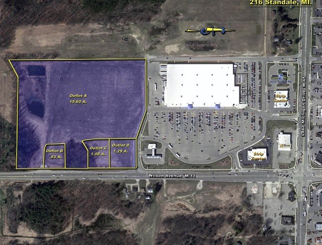
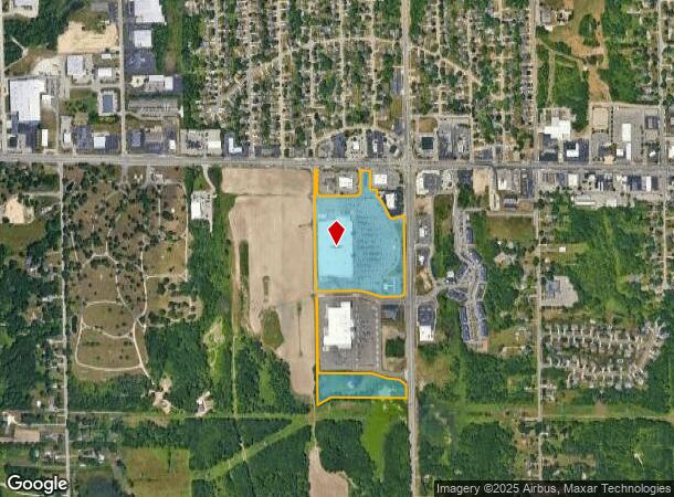
Property Record
315 Wilson Ave Nw, Grand Rapids, MI 49534
NEARBY LISTINGS FOR SALE OR LEASE
Property Detail
315 Wilson Ave Nw
41-13-30-100-029
411330100029 PART OF NW 1/4 COM 410.0 FT N 88D 21M 14S W ALONG N SEC LINE & 62.02 FT S 0D 13M 19S W FROM N 1/4 COR TH S 0D
Storemultistory
Kent
X
Michigan
26081C0384D
27.89 AC
2024
W Grand Rapids/Walker
2025
West Michigan
011702
Grand Rapids-Wyoming-Kentwood, MI
209,522 SF
DEMOGRAPHICS near 315 Wilson Ave Nw
1 Mile
3 Mile
5 Mile
2024 Total Population
4,772
27,176
103,552
2029 Population
4,862
27,859
105,181
Pop Growth 2024-2029
+ 1.89%
+ 2.51%
+ 1.57%
Average Age
37
41
38
2024 Total Households
2,119
11,158
40,568
HH Growth 2024-2029
+ 1.75%
+ 2.31%
+ 1.60%
Median Household Inc
$64,542
$75,503
$68,818
Avg Household Size
2.20
2.40
2.50
2024 Avg HH Vehicles
2.00
2.00
2.00
Median Home Value
$245,289
$249,900
$219,566
Median Year Built
1988
1983
1969
Nearby Places
Map Layers
Map Styles
 Street
 Aerial
- Restaurants
- Banks
- Shops
- Fitness
- Groceries
PUBLIC TRANSPORTATION
COMMUTER RAIL
DRIVE
WALK
Distance
13 min
6.2 mi
AIRPORT
Gerald R Ford International
DRIVE
WALK
Distance
Gerald R Ford International
33 min
20.5 mi
SALE & LEASE HISTORY
LISTING DATE
SALE/LEASE

Sep 24, 2016
For Sale
Nearby Properties
Address
Land Use
TOTAL SIZE
Lot Size
Zoning
Address
Land Use
TOTAL SIZE
Lot Size
Zoning
390,682 SF
47.73 AC
ARM - MULT
Address
Land Use
TOTAL SIZE
Lot Size
Zoning
389,181 SF
51.01 AC
RPUD - 2
Address
Land Use
TOTAL SIZE
Lot Size
Zoning
32.89 AC
TN-LDR
Address
Land Use
TOTAL SIZE
Lot Size
Zoning
343,973 SF
29.15 AC
MON-LDR
Address
Land Use
TOTAL SIZE
Lot Size
Zoning
245,620 SF
20.13 AC
RPUD - 2
Address
Land Use
TOTAL SIZE
Lot Size
Zoning
147,232 SF
18.42 AC
ARM - MULT
Address
Land Use
TOTAL SIZE
Lot Size
Zoning
107,800 SF
13.29 AC
CPUD
Address
Land Use
TOTAL SIZE
Lot Size
Zoning
123,668 SF
Address
Land Use
TOTAL SIZE
Lot Size
Zoning
78,872 SF
3.09 AC
MON-LDR
Address
Land Use
TOTAL SIZE
Lot Size
Zoning
53,653 SF
1.81 AC
MON-MDR
Address
Land Use
TOTAL SIZE
Lot Size
Zoning
37,268 SF
3.32 AC
Address
Land Use
TOTAL SIZE
Lot Size
Zoning
51,232 SF
5.04 AC
MCN-C
Address
Land Use
TOTAL SIZE
Lot Size
Zoning
1,992 SF
48.64 AC
RMT
Address
Land Use
TOTAL SIZE
Lot Size
Zoning
53,600 SF
Address
Land Use
TOTAL SIZE
Lot Size
Zoning
67,821 SF
4.95 AC
Address
Land Use
TOTAL SIZE
Lot Size
Zoning
2,173 SF
40.87 AC
RMT
Address
Land Use
TOTAL SIZE
Lot Size
Zoning
78,451 SF
4.57 AC
Address
Land Use
TOTAL SIZE
Lot Size
Zoning
13,255 SF
1.36 AC
CPUD
Address
Land Use
TOTAL SIZE
Lot Size
Zoning
62,978 SF
7.58 AC
Address
Land Use
TOTAL SIZE
Lot Size
Zoning
19,078 SF
3.46 AC
CPUD
Address
Land Use
TOTAL SIZE
Lot Size
Zoning
77,750 SF
5.46 AC
IPUD
Address
Land Use
TOTAL SIZE
Lot Size
Zoning
36,975 SF
Address
Land Use
TOTAL SIZE
Lot Size
Zoning
16,734 SF
3.76 AC
ORP
Address
Land Use
TOTAL SIZE
Lot Size
Zoning
20,020 SF
1.90 AC
C-1
Address
Land Use
TOTAL SIZE
Lot Size
Zoning
14,591 SF
6.38 AC
C-1
Address
Land Use
TOTAL SIZE
Lot Size
Zoning
14,748 SF
1.54 AC
SDD
Address
Land Use
TOTAL SIZE
Lot Size
Zoning
11,469 SF
1.45 AC
CPUD
Address
Land Use
TOTAL SIZE
Lot Size
Zoning
39,504 SF
4.82 AC
MCN-C
Address
Land Use
TOTAL SIZE
Lot Size
Zoning
19,990 SF
18.20 AC
The World's #1 Commercial Real Estate Marketplace
Connect with us
© 2026 CoStar Group
The information above has been obtained from sources believed reliable. While we do not doubt its accuracy we have not verified it and make no guarantee, warranty or representation about it. It is your responsibility to independently confirm its accuracy and completeness. Any projections, opinions, assumptions, or estimates used are for example only and do not represent the current or future performance of the property. The value of this transaction to you depends on tax and other factors which should be evaluated by your tax, financial, and legal advisors. You and your advisors should conduct a careful, independent investigation of the property to determine to your satisfaction the suitability of the property for your needs.