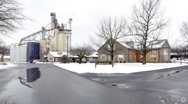
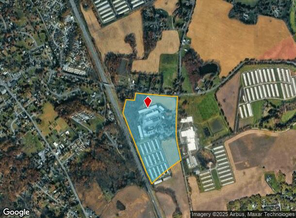
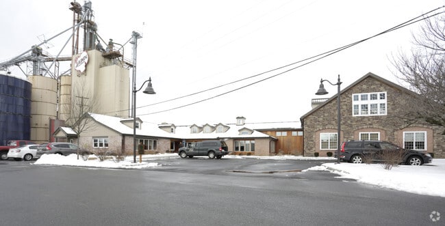
Property Record
3150 Coffeetown Rd, Orefield, PA 18069
NEARBY LISTINGS FOR SALE OR LEASE
Property Detail
3150 Coffeetown Rd
Allentown-Bethlehem-Easton, PA-NJ
Act 319P
547804553080-1
LOTS: 003 319
Officebuilding
Lehigh
X
Pennsylvania
42077C0139F
3
2025
49.30 AC
2025
Lehigh Valley
005503
Philadelphia
12,982 SF
DEMOGRAPHICS near 3150 Coffeetown Rd
1 Mile
3 Mile
5 Mile
2024 Total Population
2,176
16,239
89,615
2029 Population
2,195
16,411
90,488
Pop Growth 2024-2029
+ 0.87%
+ 1.06%
+ 0.97%
Average Age
42
42
42
2024 Total Households
831
6,004
34,532
HH Growth 2024-2029
+ 0.84%
+ 1.05%
+ 0.95%
Median Household Inc
$76,847
$92,627
$83,825
Avg Household Size
2.50
2.60
2.50
2024 Avg HH Vehicles
2.00
2.00
2.00
Median Home Value
$361,274
$330,492
$280,992
Median Year Built
1978
1981
1975
Nearby Places
Map Layers
Map Styles
 Street
 Aerial
- Restaurants
- Banks
- Shops
- Fitness
- Groceries
PUBLIC TRANSPORTATION
AIRPORT
Lehigh Valley International
DRIVE
WALK
Distance
Lehigh Valley International
19 min
8.9 mi
Freight Ports
Port of Philadelphia
DRIVE
WALK
Distance
Port of Philadelphia
82 min
62.5 mi
Nearby Properties
Address
Land Use
TOTAL SIZE
Lot Size
Zoning
Address
Land Use
TOTAL SIZE
Lot Size
Zoning
74,985 SF
112.49 AC
RR-2
Address
Land Use
TOTAL SIZE
Lot Size
Zoning
61,493 SF
47 AC
AR-I
Address
Land Use
TOTAL SIZE
Lot Size
Zoning
73,980 SF
88.46 AC
AR-I
Address
Land Use
TOTAL SIZE
Lot Size
Zoning
810,010 SF
62.47 AC
LI-B
Address
Land Use
TOTAL SIZE
Lot Size
Zoning
513,976 SF
46.77 AC
LI-B
Address
Land Use
TOTAL SIZE
Lot Size
Zoning
170,208 SF
41.45 AC
R-3
Address
Land Use
TOTAL SIZE
Lot Size
Zoning
11,966 SF
134.70 AC
AR-I
Address
Land Use
TOTAL SIZE
Lot Size
Zoning
352,946 SF
19.83 AC
LI-B
Address
Land Use
TOTAL SIZE
Lot Size
Zoning
141,550 SF
32.12 AC
IC-1
Address
Land Use
TOTAL SIZE
Lot Size
Zoning
71,108 SF
11.66 AC
R-3
Address
Land Use
TOTAL SIZE
Lot Size
Zoning
1,662 SF
50.40 AC
VR
Address
Land Use
TOTAL SIZE
Lot Size
Zoning
66,835 SF
19.49 AC
VR
Address
Land Use
TOTAL SIZE
Lot Size
Zoning
82,305 SF
198.43 AC
SR
Address
Land Use
TOTAL SIZE
Lot Size
Zoning
1,600 SF
87.62 AC
IC-1
Address
Land Use
TOTAL SIZE
Lot Size
Zoning
49,502 SF
6.24 AC
LI-B
Address
Land Use
TOTAL SIZE
Lot Size
Zoning
40.61 AC
PC
Address
Land Use
TOTAL SIZE
Lot Size
Zoning
64,809 SF
9.66 AC
SR
Address
Land Use
TOTAL SIZE
Lot Size
Zoning
37,642 SF
5.11 AC
R-3
Address
Land Use
TOTAL SIZE
Lot Size
Zoning
54,501 SF
20.09 AC
IC-1
Address
Land Use
TOTAL SIZE
Lot Size
Zoning
28,942 SF
14.24 AC
R-3
Address
Land Use
TOTAL SIZE
Lot Size
Zoning
50,933 SF
44.01 AC
IC-1
Address
Land Use
TOTAL SIZE
Lot Size
Zoning
63,750 SF
9.96 AC
C
Address
Land Use
TOTAL SIZE
Lot Size
Zoning
64,206 SF
16.31 AC
RR-2
Address
Land Use
TOTAL SIZE
Lot Size
Zoning
102,250 SF
14 AC
IC-1
Address
Land Use
TOTAL SIZE
Lot Size
Zoning
31,168 SF
2.88 AC
AR-I
Address
Land Use
TOTAL SIZE
Lot Size
Zoning
6,300 SF
9.28 AC
IC-1
Address
Land Use
TOTAL SIZE
Lot Size
Zoning
3,611 SF
108 AC
ME-I
Address
Land Use
TOTAL SIZE
Lot Size
Zoning
41,691 SF
2.14 AC
IC-1
Address
Land Use
TOTAL SIZE
Lot Size
Zoning
17,956 SF
2.80 AC
R-3
Address
Land Use
TOTAL SIZE
Lot Size
Zoning
28,766 SF
24.87 AC
AR-L
The World's #1 Commercial Real Estate Marketplace
Connect with us
© 2026 CoStar Group
The information above has been obtained from sources believed reliable. While we do not doubt its accuracy we have not verified it and make no guarantee, warranty or representation about it. It is your responsibility to independently confirm its accuracy and completeness. Any projections, opinions, assumptions, or estimates used are for example only and do not represent the current or future performance of the property. The value of this transaction to you depends on tax and other factors which should be evaluated by your tax, financial, and legal advisors. You and your advisors should conduct a careful, independent investigation of the property to determine to your satisfaction the suitability of the property for your needs.