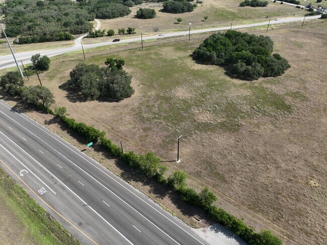
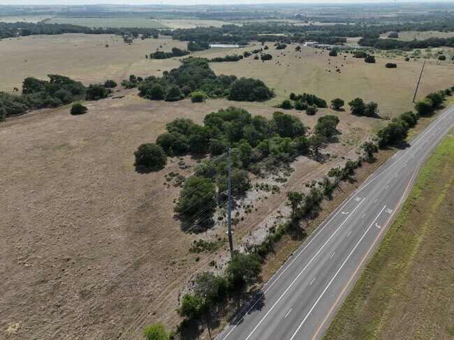
Property Record
3150 State Highway 195, Georgetown, TX 78633

Save to a Folder
{{folder.Name}}
{{folder.ListingIds.length}} Properties
{{folder.ListingIds.length}} Property
Create a New Folder
Property Detail
3150 State Highway 195
Austin-Round Rock-San Marcos, TX
AW0216 EAVES, B. SUR., ACRES 24.632
R011088
Williamson
Agriculturalland
Texas
B and X Area of moderate flood hazard, usually the area between the limits of the 100-year and 500-year floods.
24.63 AC
2024
Georgetown
2025
Austin
021603
NEARBY LISTINGS FOR SALE OR LEASE
DEMOGRAPHICS near 3150 State Highway 195
1 mile
3 mile
5 mile
2025 Total Population
1,997
16,727
48,229
2030 Population
2,286
19,022
55,212
Pop Growth 2025-2030
+ 14.47%
+ 13.72%
+ 14.48%
Average Age
65
60
53
2025 Total Households
1,044
8,236
22,047
HH Growth 2025-2030
+ 14.46%
+ 13.98%
+ 14.83%
Median Household Inc
$101,124
$97,939
$101,519
Avg Household Size
1.90
2.00
2.20
2025 Avg HH Vehicles
2.00
2.00
2.00
Median Home Value
$508,081
$477,066
$479,587
Median Year Built
2010
2004
2006
Nearby Places
Map Layers
Map Styles
 Street
 Aerial
Layers
 Traffic
 Biking
Places
Listings with unknown addresses are not visible on the map
- Restaurants
- Banks
- Shops
- Fitness
- Groceries
PUBLIC TRANSPORTATION
AIRPORT
Killeen Municipal
Drive
Walk
Distance
Killeen Municipal
42 min
33.5 mi
Robert Gray AAF
Drive
Walk
Distance
Robert Gray AAF
46 min
34.3 mi
Freight Ports
Calhoun Port
Drive
Walk
Distance
Calhoun Port
215 min
190.6 mi
SALE & LEASE HISTORY
LISTING DATE
SALE/LEASE

Aug 11, 2023
For Sale
Nearby Properties
Address
Land Use
TOTAL SIZE
Lot Size
Zoning
Address
Land Use
TOTAL SIZE
Lot Size
Zoning
495,945 SF
56.14 AC
Address
Land Use
TOTAL SIZE
Lot Size
Zoning
326,666 SF
16.74 AC
Address
Land Use
TOTAL SIZE
Lot Size
Zoning
192.21 AC
Address
Land Use
TOTAL SIZE
Lot Size
Zoning
219,839 SF
24.74 AC
Address
Land Use
TOTAL SIZE
Lot Size
Zoning
22,936 SF
111.18 AC
Address
Land Use
TOTAL SIZE
Lot Size
Zoning
62,452 SF
11 AC
Address
Land Use
TOTAL SIZE
Lot Size
Zoning
30,112 SF
4.58 AC
Address
Land Use
TOTAL SIZE
Lot Size
Zoning
Address
Land Use
TOTAL SIZE
Lot Size
Zoning
84,960 SF
5.12 AC
Address
Land Use
TOTAL SIZE
Lot Size
Zoning
26,306 SF
10.03 AC
Address
Land Use
TOTAL SIZE
Lot Size
Zoning
31,480 SF
19.73 AC
Address
Land Use
TOTAL SIZE
Lot Size
Zoning
155,448 SF
281.82 AC
Address
Land Use
TOTAL SIZE
Lot Size
Zoning
31,314 SF
34.41 AC
Address
Land Use
TOTAL SIZE
Lot Size
Zoning
25,764 SF
5.34 AC
Address
Land Use
TOTAL SIZE
Lot Size
Zoning
25.92 AC
Address
Land Use
TOTAL SIZE
Lot Size
Zoning
45,764 SF
11.23 AC
Address
Land Use
TOTAL SIZE
Lot Size
Zoning
1,453 SF
360.07 AC
Address
Land Use
TOTAL SIZE
Lot Size
Zoning
39,292 SF
200 AC
Address
Land Use
TOTAL SIZE
Lot Size
Zoning
35,534 SF
132.39 AC
1-RS
Address
Land Use
TOTAL SIZE
Lot Size
Zoning
56,950 SF
10 AC
Address
Land Use
TOTAL SIZE
Lot Size
Zoning
14,652 SF
18.54 AC
Address
Land Use
TOTAL SIZE
Lot Size
Zoning
32,935 SF
10 AC
Address
Land Use
TOTAL SIZE
Lot Size
Zoning
121.02 AC
Address
Land Use
TOTAL SIZE
Lot Size
Zoning
21,600 SF
9.17 AC
Address
Land Use
TOTAL SIZE
Lot Size
Zoning
7,968 SF
15.99 AC
Address
Land Use
TOTAL SIZE
Lot Size
Zoning
8,300 SF
1.81 AC
3-C-3
Address
Land Use
TOTAL SIZE
Lot Size
Zoning
1,080 SF
10.01 AC
Address
Land Use
TOTAL SIZE
Lot Size
Zoning
5,460 SF
4.60 AC
Address
Land Use
TOTAL SIZE
Lot Size
Zoning
8,050 SF
2.13 AC
Address
Land Use
TOTAL SIZE
Lot Size
Zoning
41,844 SF
107.05 AC
The World's #1 Commercial Real Estate Marketplace
Connect with us
© 2026 CoStar Group
The information above has been obtained from sources believed reliable. While we do not doubt its accuracy we have not verified it and make no guarantee, warranty or representation about it. It is your responsibility to independently confirm its accuracy and completeness. Any projections, opinions, assumptions, or estimates used are for example only and do not represent the current or future performance of the property. The value of this transaction to you depends on tax and other factors which should be evaluated by your tax, financial, and legal advisors. You and your advisors should conduct a careful, independent investigation of the property to determine to your satisfaction the suitability of the property for your needs.