Property Record
31507 State Road 54, Wesley Chapel, FL 33543
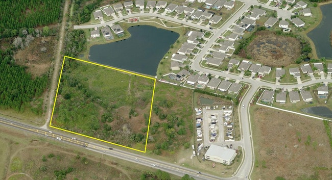
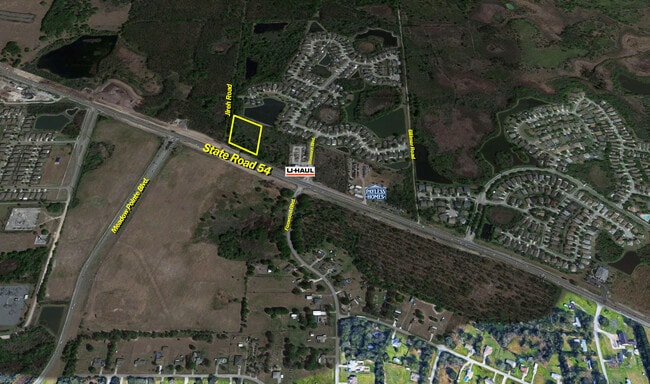

This Property Is For Sale
NEARBY LISTINGS FOR SALE OR LEASE
Property Detail
31507 State Road 54
Tampa-St. Petersburg-Clearwater, FL
S.R. 54
10-26-20-0000-00100-0060
COM AT SOUTH 1/4 CORNER OF SEC 10 TH N00DEG 1814E 600.31 FT TO NORTH R/W LINE SR 54 TH S64DEG 2325E 88.67 FT FOR POB TH N00DEG 1814E 500.00 FT TH S64DEG 1806E 428.77 FT TH S00DEG 1814W 500.00 FT TH N64DEG 1818W 428.76 FT TO POB TOGETHER WITH EASEMENT
Commercialacreage
Pasco
A
Florida
12101C0431F
6
2024
4.13 AC
2025
Pasco County
032107
Tampa/St Petersburg
DEMOGRAPHICS near 31507 State Road 54
1 Mile
3 Mile
5 Mile
2024 Total Population
4,998
41,037
110,373
2029 Population
6,062
50,586
134,462
Pop Growth 2024-2029
+ 21.29%
+ 23.27%
+ 21.83%
Average Age
35
37
39
2024 Total Households
1,574
13,590
39,035
HH Growth 2024-2029
+ 21.28%
+ 23.27%
+ 21.78%
Median Household Inc
$107,692
$101,095
$90,287
Avg Household Size
3.10
2.90
2.80
2024 Avg HH Vehicles
2.00
2.00
2.00
Median Home Value
$304,968
$301,292
$295,209
Median Year Built
2010
2009
2005
Nearby Places
- Restaurants
- Banks
- Shops
- Fitness
- Groceries
PUBLIC TRANSPORTATION
AIRPORT
Tampa International
DRIVE
WALK
Distance
Tampa International
45 min
33.3 mi
Freight Ports
Port of Tampa Bay
DRIVE
WALK
Distance
Port of Tampa Bay
41 min
29.0 mi
Nearby Properties
Address
Land Use
TOTAL SIZE
Lot Size
Zoning
Address
Land Use
TOTAL SIZE
Lot Size
Zoning
398,092 SF
22.48 AC
MPUD
Address
Land Use
TOTAL SIZE
Lot Size
Zoning
253,292 SF
22.26 AC
MPUD
Address
Land Use
TOTAL SIZE
Lot Size
Zoning
309,662 SF
59.03 AC
MF1
Address
Land Use
TOTAL SIZE
Lot Size
Zoning
301,145 SF
17.99 AC
MPUD
Address
Land Use
TOTAL SIZE
Lot Size
Zoning
252,942 SF
13.59 AC
MPUD
Address
Land Use
TOTAL SIZE
Lot Size
Zoning
418,644 SF
105.51 AC
AR
Address
Land Use
TOTAL SIZE
Lot Size
Zoning
287,834 SF
14.40 AC
MPUD
Address
Land Use
TOTAL SIZE
Lot Size
Zoning
241,371 SF
11.48 AC
MPUD
Address
Land Use
TOTAL SIZE
Lot Size
Zoning
50,016 SF
14.04 AC
MPUD
Address
Land Use
TOTAL SIZE
Lot Size
Zoning
142,552 SF
5.69 AC
MPUD
Address
Land Use
TOTAL SIZE
Lot Size
Zoning
109,440 SF
3.28 AC
C2
Address
Land Use
TOTAL SIZE
Lot Size
Zoning
92,475 SF
19.45 AC
MPUD
Address
Land Use
TOTAL SIZE
Lot Size
Zoning
19.81 AC
MPUD
Address
Land Use
TOTAL SIZE
Lot Size
Zoning
6.13 AC
MPUD
Address
Land Use
TOTAL SIZE
Lot Size
Zoning
90,759 SF
4.29 AC
MPUD
Address
Land Use
TOTAL SIZE
Lot Size
Zoning
93,933 SF
3.63 AC
C2
Address
Land Use
TOTAL SIZE
Lot Size
Zoning
90,404 SF
17.90 AC
MPUD
Address
Land Use
TOTAL SIZE
Lot Size
Zoning
129,416 SF
3.87 AC
C2
Address
Land Use
TOTAL SIZE
Lot Size
Zoning
80,584 SF
22.43 AC
MPUD
Address
Land Use
TOTAL SIZE
Lot Size
Zoning
14.84 AC
MPUD
Address
Land Use
TOTAL SIZE
Lot Size
Zoning
93,395 SF
6.71 AC
MPUD
Address
Land Use
TOTAL SIZE
Lot Size
Zoning
91,050 SF
4.18 AC
C2
Address
Land Use
TOTAL SIZE
Lot Size
Zoning
11,189 SF
34.32 AC
C2
Address
Land Use
TOTAL SIZE
Lot Size
Zoning
48,241 SF
7.67 AC
MPUD
Address
Land Use
TOTAL SIZE
Lot Size
Zoning
46,689 SF
10.06 AC
C2
Address
Land Use
TOTAL SIZE
Lot Size
Zoning
69,405 SF
2.15 AC
MPUD
Address
Land Use
TOTAL SIZE
Lot Size
Zoning
55,697 SF
7.78 AC
MPUD
Address
Land Use
TOTAL SIZE
Lot Size
Zoning
31,857 SF
3.46 AC
MPUD
Address
Land Use
TOTAL SIZE
Lot Size
Zoning
15.06 AC
MPUD
Address
Land Use
TOTAL SIZE
Lot Size
Zoning
104,720 SF
13.22 AC
C2
The World's #1 Commercial Real Estate Marketplace
Connect with us
© 2025 CoStar Group
The information above has been obtained from sources believed reliable. While we do not doubt its accuracy we have not verified it and make no guarantee, warranty or representation about it. It is your responsibility to independently confirm its accuracy and completeness. Any projections, opinions, assumptions, or estimates used are for example only and do not represent the current or future performance of the property. The value of this transaction to you depends on tax and other factors which should be evaluated by your tax, financial, and legal advisors. You and your advisors should conduct a careful, independent investigation of the property to determine to your satisfaction the suitability of the property for your needs.