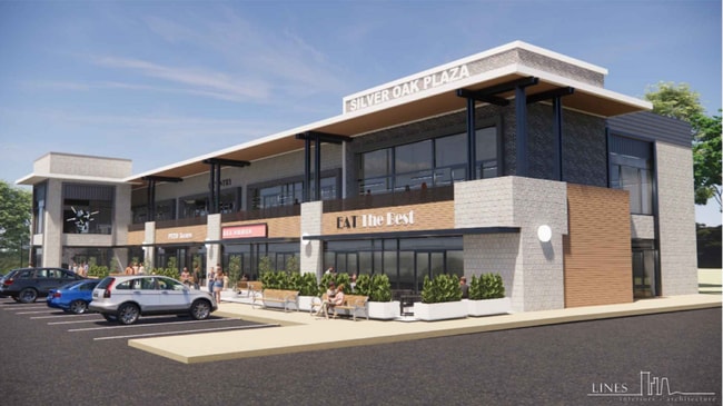
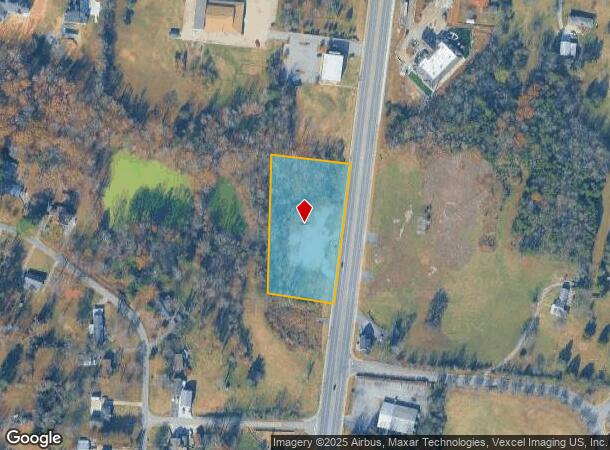
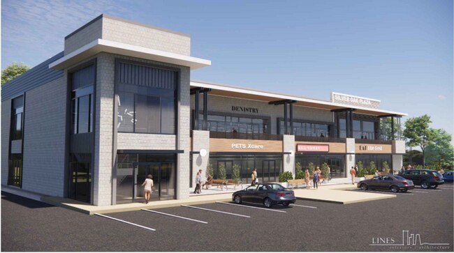
Property Record
3152 N Mount Juliet Rd, Mount Juliet, TN 37122
NEARBY LISTINGS FOR SALE OR LEASE
Property Detail
3152 N Mount Juliet Rd
072A-A-001.00
DISTRICT: 01, COUNTY AREA: M13
Residentialacreage
Wilson
X
Tennessee
47189C0134E
2.40 AC
2024
Mt Juliet-Lebanon
2024
Nashville
030309
Nashville-Davidson--Murfreesboro--Franklin, TN
1,154 SF
DEMOGRAPHICS near 3152 N Mount Juliet Rd
1 Mile
3 Mile
5 Mile
2024 Total Population
4,485
29,625
80,527
2029 Population
5,258
34,971
91,894
Pop Growth 2024-2029
+ 17.24%
+ 18.05%
+ 14.12%
Average Age
39
39
40
2024 Total Households
1,548
10,364
29,896
HH Growth 2024-2029
+ 17.05%
+ 17.95%
+ 13.58%
Median Household Inc
$97,111
$100,547
$96,640
Avg Household Size
2.80
2.80
2.60
2024 Avg HH Vehicles
2.00
2.00
2.00
Median Home Value
$332,388
$367,845
$358,901
Median Year Built
1999
2001
1999
Nearby Places
- Restaurants
- Banks
- Shops
- Fitness
- Groceries
PUBLIC TRANSPORTATION
COMMUTER RAIL
Mt Juliet (East Corridor Line - Tennessee Regional Transportation Authority Music City Star (Music City Star))
DRIVE
WALK
Distance
Mt Juliet (East Corridor Line - Tennessee Regional Transportation Authority Music City Star (Music City Star))
2 min
1.3 mi
Martha (East Corridor Line - Tennessee Regional Transportation Authority Music City Star (Music City Star))
DRIVE
WALK
Distance
Martha (East Corridor Line - Tennessee Regional Transportation Authority Music City Star (Music City Star))
11 min
6.3 mi
AIRPORT
Nashville International
DRIVE
WALK
Distance
Nashville International
20 min
14.7 mi
Nearby Properties
Address
Land Use
TOTAL SIZE
Lot Size
Zoning
Address
Land Use
TOTAL SIZE
Lot Size
Zoning
1,493,463 SF
54.91 AC
Address
Land Use
TOTAL SIZE
Lot Size
Zoning
375,981 SF
24.70 AC
Address
Land Use
TOTAL SIZE
Lot Size
Zoning
384,263 SF
27.59 AC
Address
Land Use
TOTAL SIZE
Lot Size
Zoning
611,467 SF
88.97 AC
Address
Land Use
TOTAL SIZE
Lot Size
Zoning
296,500 SF
6.95 AC
Address
Land Use
TOTAL SIZE
Lot Size
Zoning
105,709 SF
11.38 AC
Address
Land Use
TOTAL SIZE
Lot Size
Zoning
528,580 SF
25 AC
Address
Land Use
TOTAL SIZE
Lot Size
Zoning
183,224 SF
23.62 AC
CMU
Address
Land Use
TOTAL SIZE
Lot Size
Zoning
86,013 SF
7 AC
Address
Land Use
TOTAL SIZE
Lot Size
Zoning
122,364 SF
16.73 AC
CMU
Address
Land Use
TOTAL SIZE
Lot Size
Zoning
240,415 SF
16.52 AC
Address
Land Use
TOTAL SIZE
Lot Size
Zoning
38,625 SF
13 AC
RS40
Address
Land Use
TOTAL SIZE
Lot Size
Zoning
88,495 SF
8.75 AC
Address
Land Use
TOTAL SIZE
Lot Size
Zoning
66,043 SF
15 AC
Address
Land Use
TOTAL SIZE
Lot Size
Zoning
65,428 SF
5.65 AC
PUD
Address
Land Use
TOTAL SIZE
Lot Size
Zoning
61,459 SF
10.72 AC
CMU
Address
Land Use
TOTAL SIZE
Lot Size
Zoning
19,204 SF
9.23 AC
Address
Land Use
TOTAL SIZE
Lot Size
Zoning
91,365 SF
14.87 AC
CRC
Address
Land Use
TOTAL SIZE
Lot Size
Zoning
143,165 SF
144 AC
Address
Land Use
TOTAL SIZE
Lot Size
Zoning
72,064 SF
8.34 AC
Address
Land Use
TOTAL SIZE
Lot Size
Zoning
32,091 SF
3.69 AC
Address
Land Use
TOTAL SIZE
Lot Size
Zoning
50,134 SF
3.40 AC
Address
Land Use
TOTAL SIZE
Lot Size
Zoning
15,125 SF
1 AC
Address
Land Use
TOTAL SIZE
Lot Size
Zoning
80,823 SF
5.84 AC
IR
Address
Land Use
TOTAL SIZE
Lot Size
Zoning
23,911 SF
1.70 AC
Address
Land Use
TOTAL SIZE
Lot Size
Zoning
66,170 SF
11.30 AC
Address
Land Use
TOTAL SIZE
Lot Size
Zoning
45,262 SF
4.11 AC
Address
Land Use
TOTAL SIZE
Lot Size
Zoning
29,697 SF
2.17 AC
Address
Land Use
TOTAL SIZE
Lot Size
Zoning
22,356 SF
2.02 AC
A
Address
Land Use
TOTAL SIZE
Lot Size
Zoning
40,704 SF
2.76 AC
CTC
The World's #1 Commercial Real Estate Marketplace
Connect with us
© 2025 CoStar Group
The information above has been obtained from sources believed reliable. While we do not doubt its accuracy we have not verified it and make no guarantee, warranty or representation about it. It is your responsibility to independently confirm its accuracy and completeness. Any projections, opinions, assumptions, or estimates used are for example only and do not represent the current or future performance of the property. The value of this transaction to you depends on tax and other factors which should be evaluated by your tax, financial, and legal advisors. You and your advisors should conduct a careful, independent investigation of the property to determine to your satisfaction the suitability of the property for your needs.