Property Record
3152 Us Highway 17 S, Chocowinity, NC 27817
NEARBY LISTINGS FOR SALE OR LEASE
-
-
View all Chocowinity listings for sale on LoopNet.com
Property Detail
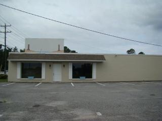
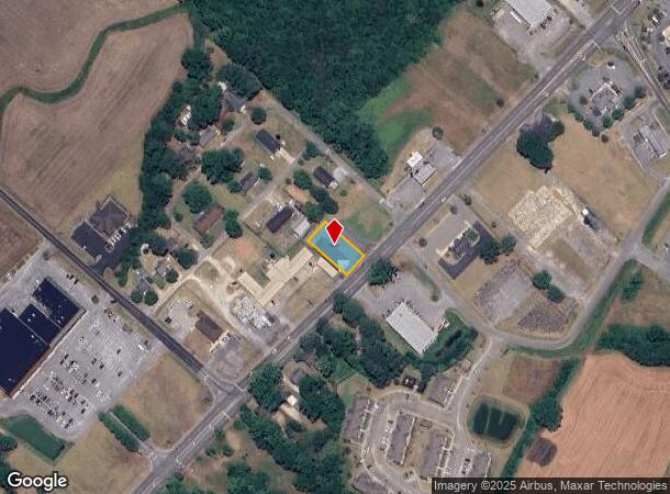
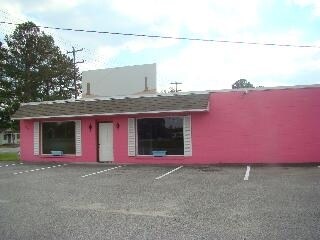
3152 Us Highway 17 S
5664-68-6534
1 LOT #8 PATRICK
Funeralhome
Beaufort
X
North Carolina
3720566400K
8
2025
0.26 AC
2025
North Carolina Northeast Area
931002
Other Market Areas
4,368 SF
Washington, NC
DEMOGRAPHICS near 3152 Us Highway 17 S
1 Mile
3 Mile
5 Mile
2024 Total Population
585
4,604
17,985
2029 Population
576
4,571
17,872
Pop Growth 2024-2029
(1.54%)
(0.72%)
(0.63%)
Average Age
44
46
44
2024 Total Households
254
2,063
7,833
HH Growth 2024-2029
(1.57%)
(0.73%)
(0.64%)
Median Household Inc
$39,999
$51,842
$42,832
Avg Household Size
2.30
2.20
2.30
2024 Avg HH Vehicles
2.00
2.00
2.00
Median Home Value
$242,857
$203,713
$168,729
Median Year Built
1981
1983
1978
Nearby Places
Map Layers
Map Styles
 Street
 Aerial
- Restaurants
- Banks
- Shops
- Fitness
- Groceries
PUBLIC TRANSPORTATION
AIRPORT
Pitt-Greenville
DRIVE
WALK
Distance
Pitt-Greenville
38 min
24.1 mi
Freight Ports
Port of Morehead City
DRIVE
WALK
Distance
Port of Morehead City
106 min
73.5 mi
Nearby Properties
Address
Land Use
TOTAL SIZE
Lot Size
Zoning
Address
Land Use
TOTAL SIZE
Lot Size
Zoning
297,021 SF
28.85 AC
L1
Address
Land Use
TOTAL SIZE
Lot Size
Zoning
43,310 SF
4.86 AC
Address
Land Use
TOTAL SIZE
Lot Size
Zoning
3.51 AC
Address
Land Use
TOTAL SIZE
Lot Size
Zoning
51,300 SF
1.41 AC
Address
Land Use
TOTAL SIZE
Lot Size
Zoning
12,167 SF
39.81 AC
Address
Land Use
TOTAL SIZE
Lot Size
Zoning
43,535 SF
18.83 AC
Address
Land Use
TOTAL SIZE
Lot Size
Zoning
4,310 SF
118.29 AC
Address
Land Use
TOTAL SIZE
Lot Size
Zoning
30,328 SF
1.24 AC
B1H
Address
Land Use
TOTAL SIZE
Lot Size
Zoning
27,864 SF
0.92 AC
RHD
Address
Land Use
TOTAL SIZE
Lot Size
Zoning
6,486 SF
213.79 AC
Address
Land Use
TOTAL SIZE
Lot Size
Zoning
10,633 SF
8.46 AC
I2
Address
Land Use
TOTAL SIZE
Lot Size
Zoning
33,680 SF
0.60 AC
B1H
Address
Land Use
TOTAL SIZE
Lot Size
Zoning
3.71 AC
Address
Land Use
TOTAL SIZE
Lot Size
Zoning
57,404 SF
5.61 AC
B-1 BUSINE
Address
Land Use
TOTAL SIZE
Lot Size
Zoning
5,146 SF
14.54 AC
I1
Address
Land Use
TOTAL SIZE
Lot Size
Zoning
24,332 SF
0.19 AC
Address
Land Use
TOTAL SIZE
Lot Size
Zoning
Address
Land Use
TOTAL SIZE
Lot Size
Zoning
5,172 SF
2.56 AC
R3
Address
Land Use
TOTAL SIZE
Lot Size
Zoning
278,544 SF
37.90 AC
CB
Address
Land Use
TOTAL SIZE
Lot Size
Zoning
19,806 SF
0.89 AC
Address
Land Use
TOTAL SIZE
Lot Size
Zoning
Address
Land Use
TOTAL SIZE
Lot Size
Zoning
15,412 SF
0.90 AC
R15S
Address
Land Use
TOTAL SIZE
Lot Size
Zoning
10,037 SF
0.26 AC
Address
Land Use
TOTAL SIZE
Lot Size
Zoning
2,664 SF
20.59 AC
Address
Land Use
TOTAL SIZE
Lot Size
Zoning
25,642 SF
0.27 AC
B1H
Address
Land Use
TOTAL SIZE
Lot Size
Zoning
138,503 SF
10.41 AC
L1
Address
Land Use
TOTAL SIZE
Lot Size
Zoning
15,490 SF
1.56 AC
RHD
Address
Land Use
TOTAL SIZE
Lot Size
Zoning
26,003 SF
0.30 AC
B1H
Address
Land Use
TOTAL SIZE
Lot Size
Zoning
30.78 AC
Address
Land Use
TOTAL SIZE
Lot Size
Zoning
22,144 SF
5.76 AC
R3
The World's #1 Commercial Real Estate Marketplace
Connect with us
© 2025 CoStar Group
The information above has been obtained from sources believed reliable. While we do not doubt its accuracy we have not verified it and make no guarantee, warranty or representation about it. It is your responsibility to independently confirm its accuracy and completeness. Any projections, opinions, assumptions, or estimates used are for example only and do not represent the current or future performance of the property. The value of this transaction to you depends on tax and other factors which should be evaluated by your tax, financial, and legal advisors. You and your advisors should conduct a careful, independent investigation of the property to determine to your satisfaction the suitability of the property for your needs.