Property Record
31526 Castaic Rd, Castaic, CA 91384
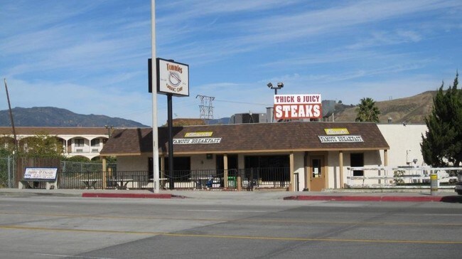

Property Detail
31526 Castaic Rd
2865-010-023
*LAND DESC IN DOC 0002852,760907 *POR OF SE 1/4 OF NW 1/4 OF SEC 25 T 5N R 17W
Restaurantbuilding
Los Angeles
LCC3*
California
B and X Area of moderate flood hazard, usually the area between the limits of the 100-year and 500-year floods.
25
2025
0.14 AC
2025
Santa Clarita Valley
920102
Los Angeles
1,302 SF
Los Angeles-Long Beach-Glendale, CA
NEARBY LISTINGS FOR SALE OR LEASE
-
-
View all Castaic listings for sale on LoopNet.com
DEMOGRAPHICS near 31526 Castaic Rd
1 mile
3 mile
5 mile
2025 Total Population
6,944
23,277
49,972
2030 Population
6,757
23,004
49,454
Pop Growth 2025-2030
(2.69%)
(1.17%)
(1.04%)
Average Age
40
40
39
2025 Total Households
2,046
5,584
14,155
HH Growth 2025-2030
(3.47%)
(1.99%)
(1.41%)
Median Household Inc
$104,022
$137,719
$146,960
Avg Household Size
2.90
3.10
3.10
2025 Avg HH Vehicles
2.00
3.00
2.00
Median Home Value
$727,530
$761,032
$779,629
Median Year Built
1985
1991
2000
Nearby Places
Map Layers
Map Styles
 Street
 Aerial
Layers
 Traffic
 Biking
Places
Listings with unknown addresses are not visible on the map
- Restaurants
- Banks
- Shops
- Fitness
- Groceries
PUBLIC TRANSPORTATION
COMMUTER RAIL
Santa Clarita (Antelope Valley Line - Southern California Regional Rail Authority (Metrolink))
Drive
Walk
Distance
Santa Clarita (Antelope Valley Line - Southern California Regional Rail Authority (Metrolink))
16 min
9.9 mi
AIRPORT
Bob Hope
Drive
Walk
Distance
Bob Hope
35 min
27.1 mi
Freight Ports
The Port of Hueneme
Drive
Walk
Distance
The Port of Hueneme
72 min
51.4 mi
Nearby Properties
Address
Land Use
TOTAL SIZE
Lot Size
Zoning
Address
Land Use
TOTAL SIZE
Lot Size
Zoning
125,154 SF
6.42 AC
LAC2
Address
Land Use
TOTAL SIZE
Lot Size
Zoning
42,104 SF
2.56 AC
LCA2
Address
Land Use
TOTAL SIZE
Lot Size
Zoning
44,609 SF
2.44 AC
LCA2
Address
Land Use
TOTAL SIZE
Lot Size
Zoning
37,478 SF
1.74 AC
LCA25*
Address
Land Use
TOTAL SIZE
Lot Size
Zoning
3,588 SF
1.93 AC
LCC3*
Address
Land Use
TOTAL SIZE
Lot Size
Zoning
46,275 SF
2.15 AC
LCA2
Address
Land Use
TOTAL SIZE
Lot Size
Zoning
31,753 SF
2.05 AC
LCM1.5
Address
Land Use
TOTAL SIZE
Lot Size
Zoning
71,790 SF
3.69 AC
LCA22*
Address
Land Use
TOTAL SIZE
Lot Size
Zoning
93,100 SF
4.73 AC
LCA22-A25*
Address
Land Use
TOTAL SIZE
Lot Size
Zoning
37,110 SF
2.37 AC
LCM1*
Address
Land Use
TOTAL SIZE
Lot Size
Zoning
74,372 SF
3.28 AC
Address
Land Use
TOTAL SIZE
Lot Size
Zoning
13,566 SF
1.20 AC
LCRPD80005
Address
Land Use
TOTAL SIZE
Lot Size
Zoning
77,608 SF
44.95 AC
LCM2DP*
Address
Land Use
TOTAL SIZE
Lot Size
Zoning
51,619 SF
5.15 AC
LCA2
Address
Land Use
TOTAL SIZE
Lot Size
Zoning
46,228 SF
3.17 AC
LCA2
Address
Land Use
TOTAL SIZE
Lot Size
Zoning
26,616 SF
1.92 AC
LCC3*
Address
Land Use
TOTAL SIZE
Lot Size
Zoning
16,640 SF
0.97 AC
LCR3*
Address
Land Use
TOTAL SIZE
Lot Size
Zoning
43,390 SF
2.73 AC
LCA2
Address
Land Use
TOTAL SIZE
Lot Size
Zoning
52,239 SF
2.73 AC
LCA22-A25*
Address
Land Use
TOTAL SIZE
Lot Size
Zoning
22,227 SF
2.53 AC
LCA12OOOO*
Address
Land Use
TOTAL SIZE
Lot Size
Zoning
8,529 SF
2.09 AC
LCM1*
Address
Land Use
TOTAL SIZE
Lot Size
Zoning
14,092 SF
1.22 AC
LCA25*
Address
Land Use
TOTAL SIZE
Lot Size
Zoning
16,425 SF
0.82 AC
LCC3*
Address
Land Use
TOTAL SIZE
Lot Size
Zoning
43,498 SF
2.57 AC
LCM1.5
Address
Land Use
TOTAL SIZE
Lot Size
Zoning
90,128 SF
3.85 AC
LAM1*
Address
Land Use
TOTAL SIZE
Lot Size
Zoning
15,622 SF
1.85 AC
SCBP
Address
Land Use
TOTAL SIZE
Lot Size
Zoning
21,767 SF
8.83 AC
LCA2
Address
Land Use
TOTAL SIZE
Lot Size
Zoning
215,019 SF
3.29 AC
LCA22*
The World's #1 Commercial Real Estate Marketplace
Connect with us
© 2026 CoStar Group
The information above has been obtained from sources believed reliable. While we do not doubt its accuracy we have not verified it and make no guarantee, warranty or representation about it. It is your responsibility to independently confirm its accuracy and completeness. Any projections, opinions, assumptions, or estimates used are for example only and do not represent the current or future performance of the property. The value of this transaction to you depends on tax and other factors which should be evaluated by your tax, financial, and legal advisors. You and your advisors should conduct a careful, independent investigation of the property to determine to your satisfaction the suitability of the property for your needs.