Property Record
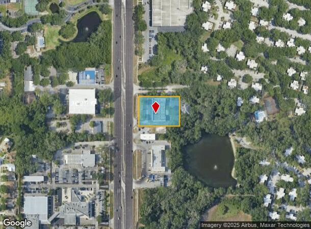
31541 Us Highway 19 N, Palm Harbor, FL 34684
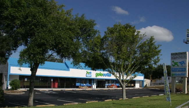

This Property Is For Sale
NEARBY LISTINGS FOR SALE OR LEASE
Property Detail
31541 Us Highway 19 N
07-28-16-00000-430-0110
W 275Ft Of N 200Ft Of S
Storebuilding
W 275FT OF N 200FT OF S 1168FT OF E 400FT OF W 500FT OF SE 1/4 OF SEC 07-28-16 CONT 1.26AC(C)
X
Pinellas
12103C0086G
Florida
2024
1.26 AC
2025
North Pinellas
027317
Tampa/St Petersburg
13,528 SF
Tampa-St. Petersburg-Clearwater, FL
DEMOGRAPHICS near 31541 Us Highway 19 N
1 Mile
3 Mile
5 Mile
2024 Total Population
10,224
90,245
188,317
2029 Population
10,121
89,744
187,592
Pop Growth 2024-2029
(1.01%)
(0.56%)
(0.38%)
Average Age
44
49
49
2024 Total Households
4,249
41,704
86,733
HH Growth 2024-2029
(1.20%)
(0.68%)
(0.48%)
Median Household Inc
$75,439
$65,345
$65,339
Avg Household Size
2.30
2.10
2.10
2024 Avg HH Vehicles
2.00
2.00
2.00
Median Home Value
$361,726
$312,415
$311,333
Median Year Built
1984
1983
1982
Nearby Places
- Restaurants
- Banks
- Shops
- Fitness
- Groceries
PUBLIC TRANSPORTATION
AIRPORT
St Pete-Clearwater International
DRIVE
WALK
Distance
St Pete-Clearwater International
30 min
16.9 mi
Tampa International
DRIVE
WALK
Distance
Tampa International
31 min
17.6 mi
Freight Ports
Port of Tampa Bay
DRIVE
WALK
Distance
Port of Tampa Bay
45 min
26.0 mi
Nearby Properties
Address
Land Use
TOTAL SIZE
Lot Size
Zoning
Address
Land Use
TOTAL SIZE
Lot Size
Zoning
661,982 SF
19.26 AC
Address
Land Use
TOTAL SIZE
Lot Size
Zoning
724,220 SF
22.95 AC
Address
Land Use
TOTAL SIZE
Lot Size
Zoning
462,206 SF
30.26 AC
RPD5
Address
Land Use
TOTAL SIZE
Lot Size
Zoning
167,201 SF
63.11 AC
AE
Address
Land Use
TOTAL SIZE
Lot Size
Zoning
406,729 SF
29.79 AC
CP1
Address
Land Use
TOTAL SIZE
Lot Size
Zoning
412,099 SF
49.21 AC
Address
Land Use
TOTAL SIZE
Lot Size
Zoning
326,008 SF
53.12 AC
Address
Land Use
TOTAL SIZE
Lot Size
Zoning
302,915 SF
55.33 AC
RPD75
Address
Land Use
TOTAL SIZE
Lot Size
Zoning
270,606 SF
53.27 AC
AE
Address
Land Use
TOTAL SIZE
Lot Size
Zoning
286,650 SF
23.36 AC
RPD5
Address
Land Use
TOTAL SIZE
Lot Size
Zoning
311,117 SF
16.96 AC
Address
Land Use
TOTAL SIZE
Lot Size
Zoning
241,867 SF
19.54 AC
Address
Land Use
TOTAL SIZE
Lot Size
Zoning
242,708 SF
26.17 AC
RPD10
Address
Land Use
TOTAL SIZE
Lot Size
Zoning
233,620 SF
14.13 AC
RPD5
Address
Land Use
TOTAL SIZE
Lot Size
Zoning
304,142 SF
12.19 AC
RPD5
Address
Land Use
TOTAL SIZE
Lot Size
Zoning
239,480 SF
18.89 AC
RPD5
Address
Land Use
TOTAL SIZE
Lot Size
Zoning
258,403 SF
10.62 AC
RPD5
Address
Land Use
TOTAL SIZE
Lot Size
Zoning
188,845 SF
33.69 AC
RPD5
Address
Land Use
TOTAL SIZE
Lot Size
Zoning
117,024 SF
56.52 AC
Address
Land Use
TOTAL SIZE
Lot Size
Zoning
161,404 SF
18.48 AC
CP2
Address
Land Use
TOTAL SIZE
Lot Size
Zoning
294,022 SF
15.75 AC
RPD5
Address
Land Use
TOTAL SIZE
Lot Size
Zoning
199,825 SF
22.75 AC
R2
Address
Land Use
TOTAL SIZE
Lot Size
Zoning
151,398 SF
15.55 AC
CP1
Address
Land Use
TOTAL SIZE
Lot Size
Zoning
311,414 SF
15.59 AC
RPD75
Address
Land Use
TOTAL SIZE
Lot Size
Zoning
250,113 SF
39.50 AC
Address
Land Use
TOTAL SIZE
Lot Size
Zoning
145,000 SF
1.26 AC
Address
Land Use
TOTAL SIZE
Lot Size
Zoning
116,975 SF
9 AC
AE
Address
Land Use
TOTAL SIZE
Lot Size
Zoning
14,334 SF
117.55 AC
Address
Land Use
TOTAL SIZE
Lot Size
Zoning
173,160 SF
5.39 AC
Address
Land Use
TOTAL SIZE
Lot Size
Zoning
115,788 SF
14.84 AC
C2
The World's #1 Commercial Real Estate Marketplace
Connect with us
© 2025 CoStar Group
The information above has been obtained from sources believed reliable. While we do not doubt its accuracy we have not verified it and make no guarantee, warranty or representation about it. It is your responsibility to independently confirm its accuracy and completeness. Any projections, opinions, assumptions, or estimates used are for example only and do not represent the current or future performance of the property. The value of this transaction to you depends on tax and other factors which should be evaluated by your tax, financial, and legal advisors. You and your advisors should conduct a careful, independent investigation of the property to determine to your satisfaction the suitability of the property for your needs.